
Thursday, December 26, 2013
Sunday, December 15, 2013
Letter from Kangding

[This is a longer, un-edited version of the article that appeared in Crikey on the changes in the Tibetan highway since my first visit in 1992]:
Tashi Delay. This must be the highest traffic jam in the
world. I’m sitting on a bus on Highway 318 at Kezi La, some 4400m in altitude,
just outside the Tibetan border town of Litang. We’re stuck here for a couple
of hours as the road is temporarily closed while a tarmac crew is at work
resurfacing a section of this part of this rollercoaster Sichuan to Lhasa
highway. Behind us the traffic is backed up as far as the eye can see – a mix
of trucks, buses and a huge number of SUVs carrying the new breed of Chinese
adventure tourist. This is the new
reality for the road to Tibet as ‘Shangri La’ experiences a tourism and
construction boom.
I started my journey in Kangding, the traditional border
town between the Han Chinese lowlands of Sichuan and the Tibetan plateau.
Statues outside the spanking new Kangding bus station portray the Chinese
coolies who used to carry heavy loads of tea on their backs up the trails from
Sichuan. This was the old ‘Tea Horse Trail’ on which tea was brought to
Kangding to be traded for Tibetan goods such as furs and jade. Nowadays Kangding
is still an important trading centre where Chinese and wild-looking Khampa
Tibetans still mingle on the streets. These days, however, you’re more likely
to see the Khampa cowboys browsing in Jeans West, or you might have a Tibetan
girl asking if you want an extra large fries with your fried chicken at the
KFC-clone Dico’s restaurant. Saffron-clad
Buddhist monks can be seen sizing up the latest iPhones in Kangding’s Apple
store, or sipping fruit smoothies from the many new food outlets lining the
main street.
On the surface, relations between Chinese and Tibetans
appear good. In the evening, hundreds of people of both races take part in a
mass Tibetan circle dance around the Kangding town square to the accompaniment
of traditional folk music played on a huge public video screen. The Chinese
take it seriously and have the dance moves down to a tee, whereas the Tibetans
just shuffle around, enjoying themselves and chatting to each other. The atmosphere
is one of innocence, tolerance and fun as young and old, men and women, sweep
around doing all the accompanying moves to tunes such as Kangding Love Song. At
the nearby Anjue Buddhist Monastery, authorities allow a large portrait of the
Dalai Lama to be displayed, below which the local Tibetans have placed prayer
candles and wads of renminbi offerings.

Below the surface, however, tensions remain. Outside the bus station I saw a dispute erupt between Tibetan van drivers and municipal cheng-guan inspectors over the issue of unofficial taxis plying for trade. It quickly escalated into a shouting and shoving match and drew a large crowd like a school playground fight, with onlookers jeering and goading for their respective sides. For a few minutes it seemed likely to turn into a riot, but the row then dissipated almost as quickly as it started when police hauled away the offending driver in a car.
During my stay in the area I overheard Chinese making
negative comments about the character of Tibetans. According to my bus driver
they were “unreliable … lazy … hotheaded … prone to fighting … too much liking
for drink.” In my own experience the Kham Tibetans were still essentially a
wild and anarchic bunch, many still yak herders in spirit, and with their own
strong sense of identity firmly linked to Buddhism and Lamaism.
The differences between the races are highlighted on the
steep rocky crags that tower over Kangding. On these cliffs the Tibetans have
painted many colourful Buddhist frescoes and chortens. Around them, the Chinese
have erected electricity pylons and mobile phone towers. A similar pattern can be seen on the
windswept hillsides in the highland areas surrounding Kangding. Beyond the
4500m Zheduo Pass above the town, the Tibetans have planted a sea of prayer
flags that flutter in bands of yellow, blue and white in the strong breeze.
Above this are carved the words “Om Mane Padme Hum” in huge white Tibetan
characters into the hillside. Nearby stands a huge and incongruous Chinese
advertising hoarding for the Kangding Airport, while below there is a cluster
of prefabricated blue worker’s huts for a gravel processing plant, where rocks
from the riverbed are crushed in a massive hopper and spewed out on a conveyor
belt onto the fleet of trucks.
In Kham the resurgence in Tibetan Buddhism is more than
matched by a resurgence in major infrastructure projects run by Chinese
state-owned companies. There is construction going on everywhere – new tunnels,
bridges, roads, apartments and hotels. On the road to Kangding the town of
Luding used to be famous for its chain link iron bridge over the churning Dadu
river that was the scene for a famous battle between Mao’s Long Marchers and
the Kuomintang soldiers. These days the once sleepy riverside town has been greatly
expanded and is now overshadowed by a huge hydro dam that has created a large
lake, the surface of which is sadly already cluttered with a raft of plastic
and polystyrene rubbish from upriver.
Perhaps connected with this, on the other side of Kangding
amid the clusters of picturesque Tibetan villages there is a huge new National
Electricity Grid relay station comprising a massive field of pylons and
transformers. Construction has also transformed the town of Kangding itself.
The ramshackle ‘old town’ that sits in a valley astride a raging mountain river
is being supplanted by a completely new Hong Kong-style town of high rises that
has been constructed on a ‘green field’ site up a nearby side valley above the
original town. This literally-named Kangding New Town is located on the route
to the Gongga Shan mountain range, whose snowy peaks now overlook a whole new
community of apartments, colleges and grandiose buildings for the various local
government departments. This once secluded valley that once contained only a
scattering of traditional Tibetan houses and a woolen mill now has landscaped
gardens, roundabouts and sports fields.
All this construction requires a workforce and supplies, and
these are much in evidence on the Sichuan-Tibet highway. Route 318 is now a
nose-to tail stream of trucks and vans bringing materials up from Sichuan. Gone
are the simple old Jiefang (Liberation) trucks, replaced by hulking
eight-wheeler Foton heavy transporters, overloaded with everything from huge
pipes and pylons to boulders, logs and scrap metal. Many are driven by the new
breed of Tibetan truckies, who decorate their windscreens with pictures of
their preferred lama, and with floral paintings and prayer flags festooned around
the cabin. In contrast, the Chinese truckers have Transformer decals on their
doors and “For Hire” signs in their windows.

But trucks only account for about half the traffic on Route 318 these days. The traffic jam I found myself in on the Kazi Pass was mostly made up of the new breed of Chinese tourist – the SUV adventurer. Clad in shiny new North Face gear and driving anything from a late model Land Rover Freelander to a Landcruiser, there are now huge numbers of newly-wealthy Chinese heading out into the hills wielding their DSLRs and walking poles. Kham is now prime vacation territory for many Chinese who are seeking an escape from the crowded and polluted lowland provinces. These are not the coach-bound tour groups with matching baseball caps following a leader with a flag and a megaphone. The new Chinese tourists have their own cars, and travel in small groups of family or friends. And more young Chinese now travel independently as backpackers, and can be seen on the outskirts of settlements along the Tibet highway trying to hitch lifts with their destination written on Chinese characters on a piece of cardboard. Cycling is also hugely popular, judging by the large numbers of Chinese cyclists to be seen sweating on mountain bikes with bulging panniers over the high passes on their way to Lhasa.
To cater for this new wave of tourism, the Kham Tibetans
have responded by converting their sturdy stone farmhouses into guesthouses and
‘backpacker’ hostels. The town of Xinduqiao above Kangding has become something
of an adventure tourism hub, with almost every house bearing a sign offering accommodation,
pony trekking and Tibetan food. The signage is all in Chinese of course – this
is a huge domestic market, and foreign tourists must account for less than 1%
of those travelling the Tibetan highway.
The change has been rapid and profound. Ten years ago I made
an arduous and uncomfortable trip to the three sacred mountain peaks at Yading,
near Daocheng. The only way to get there at that time was by an uncomfortable
and unpredictable three day bus ride over unsealed mountain roads from
Kangding. Accommodation was in wooden shacks and marquee tents that had been hastily
thrown up at the entrance to the newly established National Park to cater for
the initial trickle of visitors.
This year I returned to find that an airport had just been
opened at Yading-Daocheng – one of the higest in the world - and the influx of
visitors from the several flights a day was now catered for by a series of
flashy new hotels that had been built in Daocheng. At the once remote Yading, village
the shacks had been replaced with a series of upmarket Tibetan-style
guesthouses where you can access wifi while sipping on a 48 yuan cup of Yunnan
coffee. Entrance fees to the National Park are now set at a whopping 270 yuan,
which includes an obligatory shuttle bus, as SUVs are banned from the National
Park (I saw around a hundred 4WDs parked up in a special new car park set up at
the gateway town of Riwa). And yet despite the high fees, there are literally
hundreds of Chinese tourists swarming into Yading every day. The crowds waiting
to board the fleet of golf buggy-style electric carts that now run through the
park are so dense that it’s is almost impossible to swing a telephoto lens
without hitting someone.

In despair, I fled the hustle of Yading and tried to find some tranquility in the more off-the-beaten-track region of Gongga Shan, near Kangding. But even in the remote Yulongxi valley adjacent to this 7600m peak we found the Tibetan houses had been converted into guesthouses and ‘adventure centres’. The local Minya Tibetans are turning from yak herding to tourism. Almost every house now offers accommodation, food and horse hire. Our young Tibetan guide for the hike over the pass to the remote Konka Gompa monastery was more interested in playing with his iPhone than talking about the local features and culture.
On the bus back to Kangding we inevitably hit another
traffic jam. For four hours we were stranded in a ten mile tailback of trucks,
cars and other coaches on a remote section of road. Drivers and passenger
spilled out on to the road to smoke, crack melon seeds and sip from their
flasks of their tea. The cause wasn’t clear and there were no traffic cops to
be seen. Some said it was a landslip, others said it was more roadworks. We never found out. A young guy next to me
from Chongqing tutted and cursed as we
sat immobile for hours. He fiddled with
his phone and made the same call that everyone else made:
“I’m on the bus. Stuck in traffic … I’ll call you when we
get in.”
Then he muttered to nobody in particular: “Aiya! Even in Shangri-La there are too many
people.”
Saturday, December 14, 2013

Monday, December 09, 2013
The highest traffic jam in the world ...
Here's the actual pic of the traffic jam at 4000m that didn't get published with my Crikey article on the gridlock on the Sichuan-Tibet highway near Litang. (I can see why, not very visually appealing with the cloud obscuring the view).


The road to Tibet ...
On Highway 318 there is now a constant flow of trucks, 4WDs and coaches taking people and goods into Tibet from Sichuan. The road is still in pretty poor shape and there are any delays due to blockages, maintenance and accidents.


Sunday, December 08, 2013
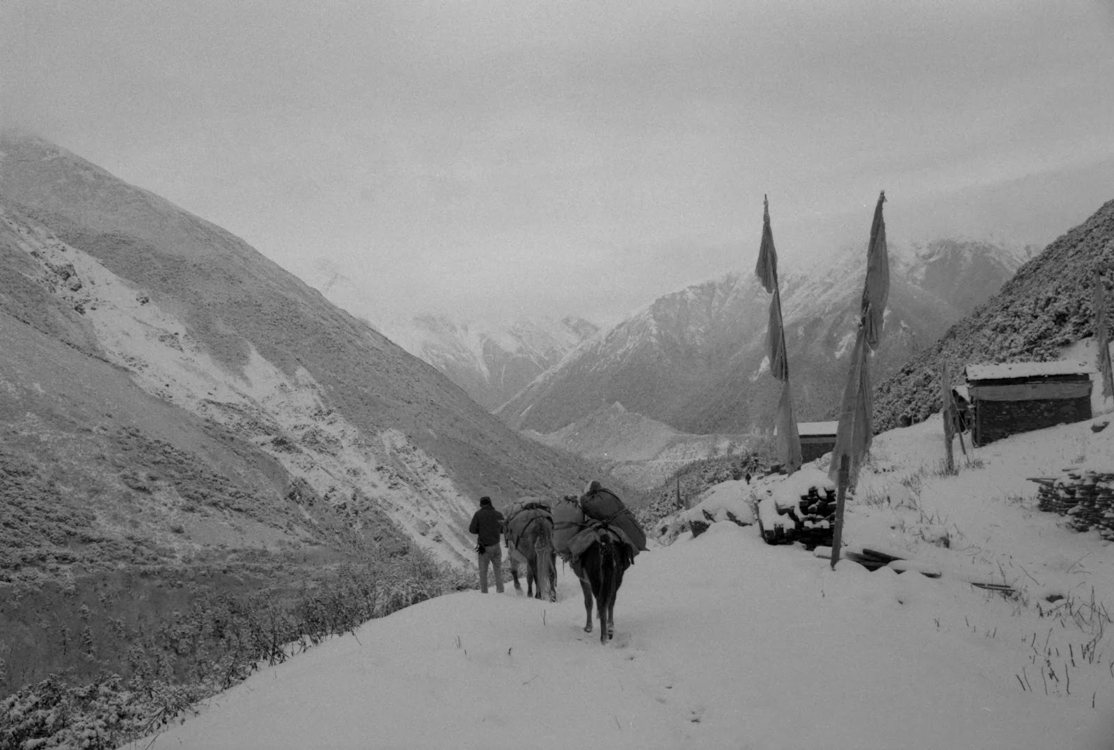
Konka Gompa in the snow - October 2013

The Buchu valley, below Konka Gompa, on the way to the Yulongxi Yakou (Pass).
Friday, December 06, 2013
Konka Gompa in the snow

This was the best view we got of Gongga Shan mountain and the monastery! Taken in mid October 2013.
Thursday, November 28, 2013

Tuesday, November 26, 2013
Monday, November 25, 2013
Going to Gongga Shan in October? Prepare for cold!

This is a view looking towards Zimei village from down the Buchu valley. The Konka Gompa monastery is round the corner to the left.
Wednesday, November 20, 2013

Tuesday, November 19, 2013
Yulongxi, Gongga Shan trek 贡嘎山 玉龙西

Here we are setting off from Yulongxi in pretty miserable weather - it got worse as the trek progressed and we arrived back here in heavy snow .
Monday, November 18, 2013

Wednesday, November 13, 2013

Sunday, November 10, 2013
If you go down to the woods today ...
Be sure of a big surprise. Well, I was surprised by the huge crowds at Yading.


Saturday, November 09, 2013

Thursday, November 07, 2013
Resting at the "Eco Lodge" shelter below Yulongxi Pass, Gongga Shan trek

Resting at the "Eco Lodge" shelter below Yulongxi Pass, Gongga Shan trek, originally uploaded by jiulong.
After walking over the pass we descended in an increasingly heavy snow fall to the Buchu river. On the way we came across an empty stone hut that was optimistically labelled an "Eco Lodge". On the way back up to the pass two days later we rested here for lunch. I think it was colder in the hut than outside!
Wednesday, November 06, 2013
On the Yulongxi Pass in snow
I'm now scanning my colour slides and B&W negatives. Will post images of my Gongga Shan and Yading trip when they are ready. Here's one to start with.


Monday, November 04, 2013
Crossing the Yulongxi Pass
This pass is a few km to the east of the more widely used Tsemi La. It offers better views of the other peaks of the Minya Konka range (on a clear day). There is only a faint track over the pass, but it is easily navigable when clear of snow. On our return trip there was more than a foot of snow underfoot right from the bottom of the trail. Fortunately we had a guide, Barder, who knew the way through the mist. I followed in his footsteps, otherwise we would have been totally lost in the whiteout.

By the way, that's not me on the horse - it's Monica, an intrepid Polish traveller who foolishly took me up on the offer of a trek to the Gongga monastery based on the prospect of wonderful views (that never materialised).

By the way, that's not me on the horse - it's Monica, an intrepid Polish traveller who foolishly took me up on the offer of a trek to the Gongga monastery based on the prospect of wonderful views (that never materialised).
Saturday, November 02, 2013
Oh dear, not a good trip ...

Just back from Sichuan where I spent three weeks doing not very much and seeing even less. I'd planned to do the outer kora around the three peaks at Yading but unfortunately the weather was poor and the guides refused to even try go out. They said the snow was too deep on the passes and they would not risk their horses or themselves. I then reverted to Plan B, to re-visit the Gongga Shan range. Again the weather was poor - as you can see from this pic taken at the Gongga gompa. Heavy snow and no views due to the weather being socked in by cloud and mist. I did prove one thing, however - Joseph Rock's claim that this monastery is cut off from the outside world for six months of the year due to heavy snow is just rubbish. We made it over one of the less know passes (Yulongxi Yakou, due east of the usual Tsemi La) in deep snow - no probs. Ah well - lesson learnt: don't go trekking to Sichuan after Golden Week!
Wednesday, October 09, 2013
In Yading for three weeks - back in November

I've taken my Rolleiflex and a few rolls of 120 film to Yading. Hoping to do the outer kora again - this time in autumn (nicer colours, more people?) and at a more relaxed pace. See you there!
Friday, October 04, 2013
Random photo: Mosuo women at Renjom Gompa monastery, near Yongning

These two ladies were at the tiny Renjom Gompa monastery, which is located half way between Yongning and Muli monastery. The monastery sits atop a hill just down the river from Wujiao, which is actually a settlement of 'Mongolian' descendents of the Genghis Khan invasion of Yunnan many centuries ago. I stayed here overnight while walking from Lugu Lake to the old monastery at Muli (Wachang town) in 1998. This photo was taken with my treasured Leica M3 camera with a slightly foggy Summicron 50mm lens.
Wednesday, October 02, 2013
Random photo: horse carving on stone en route to Gongga Shan

I came across this engraved stone on a high ridge above the Yulong Xi valley while trekking from Kangding to the monastery below Gongga Shan in 1996. It was with a pile of mani stones, but I don't think many people would ever come across it as this was in a very remote, unvisited spot, literally very much off the beaten track. We only came across it because one of our horses had wandered off and we climbed the hillside in search of it. Not sure why it was put there. I wonder if it is still there?
Tuesday, October 01, 2013
Yading outer kora: the difficult bit

This is a picture taken looking back from 'the shoulder' - the pass that skirts around the cliffs below the south side of Jambeyang. It was a steep and fraught scramble up a scree and snow slope - I didn't like it! It felt a lot steeper than it looks on this photo and I was petrified that I would lose my footing and slide/roll down the mountainside and over the edge (not shown) into the abyss. Glutton for punishment that I am, I will be facing this again in a few days when i return to Yading for a second time, to do the kora in a more leisurely fashion.
Saturday, September 28, 2013
Random photo: Muli in the green days of summer

This picture was taken with my old Leica M3 and colour print film, now both sadly departed.
Friday, September 27, 2013
Random photo: 冲古寺 temple interior, Yading

Random photo: Chonggu monastery, Yading

This is where I'll be starting my Yading outer kora trek from in a couple of weeks.
Tuesday, September 24, 2013
Trekking partner(s)? Yading, October

Sunday, September 22, 2013
Random photo: Crossing the Doker La pass from Yunnan to Tibet
 I think I posted this photo before but this as a recent higher res re-scan of the original 35mm slide. We have just crossed the Doker La and I am looking back (terrified) as we descend the steep and precarious switchback trail descending into Tibet. These guys are some strangers who are presumably doing the pilgrimage around the Kawakarpo Kora circuit.If you look closely you can see a rope running diagnonally from the pass at top right to bottom left. This is put there to assist pilgrims in descending when the pass is snow and ice bound. To descend by the path at such times would be suicidal.
Friday, September 20, 2013
Random photo: Shenrezig, here I come

In a couple of weeks I hope to be taking off to Yading, and will do the full outer circuit of the three mountains Chanadorje, Jambeyang and Shenrezig. Here's one I took of Shenrezig on our last trip three years ago.
Tuesday, September 17, 2013
October trek, Plan B - by mule to Minya Konka

Back in 1995 or thereabouts I took off from Kangding on a four-day trek to the Konka Gompa, the little monastery near the glacier emanating from Gongga Shan. It was a pretty remote spot back then - no bike track over the Tsemi La. I went in October and as you can see the weather was pretty cold. I hired a guide in Laoyulin and he took me on horseback to the monastery via the Djesi La pass and Yulongxi valley before crossing the Tsemi La. A very interesting trip and one that I hope to repeat next month if I have the time after doing the circuit of the Yading three peaks.
Saturday, September 14, 2013
Random photo: Nujiang kids

These were the Nu minority kids we saw at Dimaluo while staying there on Christmas Day. Little scamps, especially the one on the left with his Chrstmas fir tree decorations.
Friday, September 13, 2013
From the archives: Joseph Rock and the king of Muli

This is Rock with Chote Chaba, the lama king of Muli. Not sure who the other European is, but it may be William E. Simpson, a missionary who acted as Rock's translator for a brief period. They parted ways when Rock found him to be too much of a do-gooder.
Random photo: hiking in the snow near Yubeng, 2002

After my failed attempt to cross the Doker-La in April 2002, we visited the Tibetan mountain hamlet of lower Yubeng, where we spent three
frustrating days waiting in a wooden shack for the weather to clear. It didn’t.
It rained incessantly and fog blocked out any views of the surrounding
mountains. We had nothing to do except sit round a fire that gave off little
heat and hope tomorrow would bring better weather.
When the third morning dawned grey and wet, we tried to beat the encroaching cabin fever by hiking
through the deep snow to see a sacred waterfall and a ‘magic lake’. It proved
to be a miserable hard slog with slushy boots and we saw very little. Yubeng
didn’t feel like Shangri La.
Lesson learnt: don't visit this region in early spring - wait until May!
Lesson learnt: don't visit this region in early spring - wait until May!
Thursday, September 12, 2013
From the archives: Joseph Rock near his home at Nguluko, Lijiang
 Joseph Rock chose to live outside the town of Lijiang. Presumably he wanted solitude in order to devote himself to his botanical efforts and scholarship. What an amazing setting, beneath the great Jade Dragon Mountain! I presume he lived in a fairly modest courtyard house in the Naxi style. The building pictured here looks a little more rustic and presumably belongs to a farming family - the walls are made of packed earth (as they still are in many Naxi villages. It bears little resemblance the the stone- walled courtyard house that is now touted as his former residence.
As you can see, building styles hadn't changed much when I first visited the area in 1990:

Random photo: worshipping an effigy of the moutain Kawakarpo

It
was at the Fei Lai Si monastery just outside Deqin that we got a glimpse of the
“peerless peak” of Miyetzimu (Meili) that Rock described so rapturously as “the
most glorious peak my eyes were ever privileged to see. No wonder Tibetans
stand in awe and worship it. It is like a castle of a dream, an ice palace of a
fairy tale, or an enormous mausoleum with gigantic steps and buttresses all
crowned by a majestic dome of ice tapering into an ethereal spire merging into
a pale blue sky.”
By
2002 the viewing area for the mountain had become a tourist trap, with hawkers
selling joss sticks and other offerings to be made at one of the many shrines.
The tourist route also included a visit to the Minyong glacier that lies
beneath Meili Xue Shan.
Instead,
we opted to travel the same route back down into the depths of the Mekong canyon, but turned left at the river to visit the
hamlet of Yubeng. At the junction of the road near the Mekong we stopped at a
small Buddhist chapel, called the ‘Jungle
Temple’. Inside, there
were effigies of Buddhist deities, but also evidence to confirm Rock’s
observation that the local people also worship the mountain itself as a deity.
Wednesday, September 11, 2013

Random photo: Mundon village, Yalong canyon

Joseph Rock passed through Mundon (now known as Mongdong)on his way to Minya Konka (Gongga Shan) from his base in Lijiang. It took him 'five terrible days' to cross the canyon.
Tuesday, September 10, 2013
Random photos: Christianity and Buddhism in Kangding

A missal on a pew at the Catholic church in Kangding. Meanwhile, across the street ...

Bells and chanting texts at the Anjue Si Buddhist temple in the centre of Kangding
Monday, September 09, 2013
Random photo: doing the circuit of the three peaks at Yading

This was taken on day 3 - crossing the fifth pass on over Yetchetsura valley towards the lake Russo Tso. Contrary to appearances this was one of the easiest sections - compared to the 'hell' of the cliffs!
Random photo: Christmas celebrations at Baihanluo 白汉洛 Catholic church, Nujiang, Yunnan.

Baihanluo (formerly known as Peihanlo and Bahang) is a former French Catholic mission station in the valley of the Nu river (Nujiang or Salween) in NW Yunnan, China. The local people are Nu minority and a few Tibetans, and most are devout Catholics. At Christmas 2008 they were celebrating by drinking corn liquor (shuijiu), dancing and singing.
Sunday, September 08, 2013
Random photo: Catholic church interior, Baihanluo

This was taken at Christmas, hence the Nativity scene display. Joseph Rock passed through Baihanluo but said little about the local church.
Saturday, September 07, 2013
Random photo: on the Kawa Karpo pilgrimage trail

Subscribe to:
Posts (Atom)


