[Click here to go forward to Chapter 8]

On his first trip to Muli in 1924, Joseph Rock caught a tantalising glimpse of a distant trio of mountain peaks to the west, known as Konkaling or the Konka Risumgongba peaks.

This trio of mountains of around 6000 m in height, are now part of the Yading Nature Park. Rock had seen the peaks from a vantage point at Muli and he asked his new friend, the Muli king, to help him travel to the mountain range. He needed to use the Muli king's influence to win over the hostile bandits who lived in the area around the Konkaling peaks.
The mountains were located in remote territory that was controlled by a large gang of intractable Tibetan brigands ('the scum of the outlaws' as Rock put it), and off limits on pain of death not just to Chinese but even to their close Tibetan neighbours in Muli and Yongning. It was said that any outsider who encroached on the Konkaling bandits' territory would be shot on sight. The irony was that these bandits were led by a former monk, Drashetsonpen ('Trashi'), who when not out murdering and looting, maintained his devotions at a small monastery nestled within the three peaks.

The peaks were a sacred place for Tibetans, and hence Rock gave them the more romantic label of the 'Holy Mountain of the Outlaws'. The outlaws in question - the Konkaling Tibetans - were notorious for their raids on neighbouring villages, where they would plunder and kill without mercy. The Muli king had come to an arrangement with Trashi and his gang of pillagers, paying them off and allowing them free passage across his lands in return for not molesting his subjects.
Thus the Konkaling bandits would leave the Muli king's subject's in peace while slaughtering those in unlucky villages nearby that lay just outside his territory.
Here is an excerpt from Peter Goullart's book, Forgotten Kingdom, on the subject:
"North-west of Likiang and to the west of the Muli Kingdom there is an isolated mountain range called Konkaling. It consists of three peaks, about 23,000 feet high. It had been discovered and photographed by Dr Joseph Rock, who used to make expeditions to Muli where the king was a great friend of his. These mountains are a veritable breeding place of the most ruthless brigands the world has ever known. To the west of these mountains there are two vast territories known as Hsiangchen and Tongwa. They are peopled with two Tibetan tribes whose members are professional robbers and cut-throats. So wild, untamable and treacherous are they that not even other Tibetans dare to venture into these areas. Although of an enormous size, rivalling some of the large European states, none of these areas has ever been visited by a European and probably will not be for a long time to come. There is no doubt that much of interest to explorers and scientists is concealed in these inaccessible and unmapped regions. There is, for instance, a great snow peak in the bend of the Yalung River in Hsiangchen, called Neito Cavalori. Those few privileged explorers who have been lucky enough to contemplate it from a distance, compute its height at something like 28,000 feet, and it may yet prove a rival to Mount Everest.
It was these Tongwa and Hsiangchen brigands who always lay in wait for the rich caravans coming from Lhasa. Of course all Tibetan caravan men were heavily armed, and when the caravan was big enough these rascals did not dare to attack them. It was when the caravan was small or poorly armed that their chance came. Madame Alexandra David Neel nevertheless describes the Tibetan bandits as 'Les Brigands-Gentilhommes' in her book. I have known this great lady since 1939, when I met her in Tachienlu, and have a profound respect for her. She is certainly one of the greatest travellers the world has known, and I am glad she received such fortunate mercy from these robbers, who even showed a certain gallantry towards her because she was a helpless woman and a detsuma (Reverend Abbess) to boot. Personally I would rather deal with a Chinese or a Nakhi robber than a Tibetan one. A Chinese or a Nakhi robber seldom kills his victim. He robs you but he does it with a degree of finesse and delicacy, and at least leaves you your underwear to enable you to reach the nearest village with a modicum of decency. He usually forbears to search a lady, and may even listen to her protests about taking away certain items of her toilette. Not so with the Tibetan robbers. Their motto is 'Dead men tell no tales'. They shoot first and then look for anything of value on the dead man's person or in his baggage. I once heard an interesting story of how one of these Tongwa shot a man walking in the distance, only to discover afterwards that it was his own father.
I am prepared to admit that the Tibetan brigands of some other tribes may be 'gentlemen' to some degree but, from what I heard from reliable Tibetan and Nakhi friends, the Tongwa and Hsiangchen cannot be idealized by any stretch of imagination. They are so avaricious and unprincipled that even the bonds of friendship mean nothing to them, and there have been cases when a man has killed a bosom friend for the sake of a couple of rupees in his belt. Everybody in Tongwa and Hsiangchen robs, steals and kills: lamas and trapas, merchants and serfs, men and women: even children learn the trade at a tender age. It is not a question of whether this Tongwa or that Hsiangchen is a robber, but whether the man is a Tongwa or Hsiangchen.
When the caravan has been plundered and witnesses eliminated or scattered, the goods, arms and animals are taken to the robbers' lair. There the merchandise is carefully repacked and reloaded and, lo and behold, the robber chief, resplendently dressed, enters Likiang as a peaceful and affluent merchant, at the head of a sizable caravan. No questions are asked and no explanations are vouchsafed. Of course rumours do travel, and travel fast; but rumours are rumours and proofs are proofs. The bogus merchant knows that the people know and the people know that he knows what they know, but everything proceeds according to form. The merchant sells his goods, gives generous parties right and left and acquires merit by rich donations to the local lamaseries.’

Rock was supplied with a 'safe conduct' pass and a guide by the Muli king, and in March 1928 he set off to visit the three sacred Konkaling mountains (Shenrezig, Jambeyang and Chanadorje) of the Konka Risumgongba range
He started his journey in Kunming [then known as Yunnan-fu] from where he left with his Naxi "boy" assistants, making his way first to Muli via Dali and Lijiang. Though he fails to mention it in his article, Rock was also accompanied by a young American assistant, William Hagen, a lawyer who had been working at the US consulate in Kunming. Rock took him along as insurance, after being warned that bandit activity was especially bad in the upcountry areas of Yunnan. Hagen was also meant to act as an assistant to Rock, doing much of the donkey work, such as sorting and preparing botanic samples for shipping back to the US.
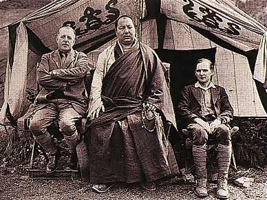
Rock was intrigued by the "blank on the map" where the Konkaling peaks were, so he persuaded the Muli king to vouch for him and to provide a ‘laisser passez’ for the Konkaling bandits. He smoothed the way by presenting the Muli king with a gold American $20 coin, and more importantly, copies of the National Geographic magazine, in which the king's portraits featured prominently.
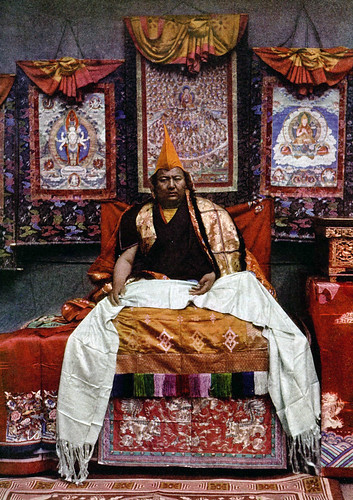
While talking with the Muli king, Rock was asked to explain a little more about world events. The king became apprehensive when told that the Tsar of Russia and Germany's Kaiser had recently been de-throned, the Muli ruler no doubt wondering if he would meet the same fate [which in fact he would, by an assassin's bullet, within ten years]. Rock then tried to keep a straight face when the king asked him about a picture of Puss in Boots, and where this strange animal kingdom might be. But perhaps the king was not so stupid. When Rock told him about aeroplanes, he asked why Americans did not fly to the moon!

After departing with the king's blessing in late April 1928 from the monastery of Kopati, Rock headed westwards, ascending up through the pine forests to the peaks of Mt Mitzuga, aiming for the Shuiluo river canyon that marked the border between Muli and Konkaling territory.
His party comprised 36 mules and horses, 21 Nashi assistants, and the head lama of Muli monastery, who came along reluctantly to act as a guide. Rock describes the trip in an article in the July 1931 issue of the National Geographic, in which he claims to be 'the first white man to visit the Konkaling peaks'. He says other explorers and plant hunters such as Kingdon Ward had been in the area but had never got close enough to see the peaks in good weather.

Rock approached from the eastern (Muli) side, dipping down into the stifling heat of the cavernous Shouchu river valley and then climbing out on the western side up to the village of Garu (now known as Galuo), whose tough Apache-like Tibetan inhabitants he compared favourably to the snivelling and servile subjects of the Muli king. However, even these 'proud and virile' men were reluctant to escort Rock around the peaks because of the bandit threat, until Rock mocked them by suggesting he take some Garu women instead.

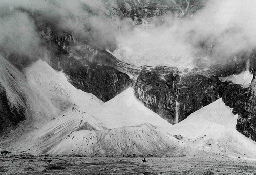
From Garu, Rock ascended again through virgin spruce and fir forest, and at higher altitudes through rhododendron forest, then crossed over a high pass to reach the mountains of Konka Risumgongpa, and to make a circuit of the three peaks in the usual Tibetan Buddhist clockwise fashion. His first camp was at 15,300 feet, below the scree slopes and glaciers of Chanadorje ('huge moraines resembling a vast amphitheatre'), where Rock says he got a great view when the clouds finally parted - 'revealing The Holder of the Thunderbolt - a truncated pyramid flanked by broad buttresses like the wings of a stupendous bat'.

This place the locals called Konka Djra-nse, or Sea Dragon's Snout. This is where, on our 'outer kora' of 2010, we joined up with Rocks circuit, although we had come from the western side. We also got great views of the whole face of Chanadorje at this spot, and it is odd that Rock does not include any photos of this impressive view of the mountain in his article. He only includes a picture of the glacier moraines at the foot of Chanadorje, and by the look of things there was much cloud about during Rock's visit.

From the natural campground below Chanadorje called Shingara, Rock says he ascended a pass and followed a valley called the Saiyo Katso, which culminated in two smaller peaks known as Dzambala. We also followed this valley, which gave great views of the south eastern face of Chanadorje, and it also gave us glimpses of the sliver-like side profile of Jambeyang to the southwest.
This valley also had a small hanging valley within it, with a beautiful small lake. At this point Rock ordered his local Tibetan helpers to collect some specimens of local wildlife (he says he shot some snow pigeons), but they objected to the taking of life. Rock found this amusing, as the locals seemed to have no qualms about taking human lives.
His party also came across a few Konkaling Tibetans skulking among the trees. They had been scared by his rifle shots, and had hidden because they assumed that humans were being shot at ('since no one hereabouts wastes shot and powder on useless pigeons as we had done'). The head of this valley was blocked by an imposing black vertical wall of rock below two minor peaks. I presume this is the Yaka Pass that Rock refers to. We just called it The Wall, and it looked like a very steep ascent to a knife edge ridge.

For someone who regularly used plenty of florid prose, Rock is oddly restrained in his description of the rigours of the journey around the peaks, saying only that 'our journey proved very arduous'. He describes the crossing of the Yaka Pass under a torrential downpour, with no trail to follow, and the mules and humans unable to find a good footing on the slabs of schists covered in rainwater and slippery grey mud. We had exactly the same experience, summed up by this paragraph: 'Climbing at such altitudes is difficult enough in good weather, but in a terrific hail and rain storm, with a howling gale driving the icy pellets into one's face and making one gasp for breath in this rarefied atmosphere, it is doubly disagreeable.'

After crossing the Yaka Pass, Rock says he camped at the foot of hanging glaciers of moraines on the southern slopes of Mt Jambeyang. We also camped here, although it was far from an ideal camping spot. Rock says his entourage sought shelter in a cavelike space under an overhanging cliff, where pilgrims had erected chortens.
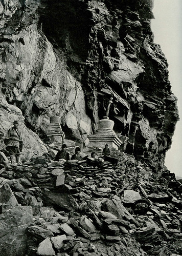

We also saw this sacred site, which was pretty much unchanged from the photograph published by Rock. There was still a makeshift wall and a couple of chortens in disrepair. And like Rock, we also spent the night listening to the thundering noise of falling blocks of ice, tumbling down from the heights of Jambeyang's glaciers.
It was near here that Rock says he encountered the dreaded bandit chief himself, Drashetsonpen, who was also making a circuit of the peaks (perhaps in expiation of his heinous crimes). His gang had sullen faces, "hinting at looting and murder".
Rock sat down in the pouring rain with this bandit leader and his thirty followers, and shared some rancid yak butter and cheese. They made little conversation except for a reassurance that Rock would not be molested.

The next section, which we found to be a difficult walk along scree and snow under steep cliffs, is given little mention by Rock, except to say that his party shot a wapiti, but they were unable to bag it because the body rolled down the steep slope into the Lawatong valley far below.

The trail then makes a sudden turn northwards around the cliff shoulder, and Rock describes this new valley as Yetchesura. We found it quite easy going after the steep scree, but Rock complains that that “the enormous slabs as smooth as a billiard table, covered with large patches of ice and snow made travelling most disagreeable.”

His next camp, like ours, was by one of the larger lakes in the area, a long thin lake he calls Russo Tso ('where dwell the worst of all the Konkaling outlaws').

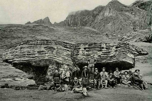
Before we reached this we had to cross two further but relatively easy passes. After the first we came down to a fertile flat area of grass, in the middle of which was a large slab of rock as big as a house, which has become know as 'Rock's rock'.
He includes a picture of his entourage sitting around this huge slab of schist, which he says must have fallen from the lower slopes of Mt Jambeyang.

While camping next to the lake, Rock says his guides were nervous, pointing up at the high slopes above them where Tibetans (presumably bandits) could be seen in the rocky ramparts, watching them.

From this lake, Rocks party climbed up to another pass with several exits (we called it the three-way pass), which divides Jambeyang from Shenrezig. This pass connects with the Konka Den valley, which is now part of the main tourist trail of Yading, giving views of all three peaks. Rock descended with his party, and his visit to and stay at the Tsengu Monastery (now known as Chonggu).
In 1928 when Joseph Rock finally reached the Chonggu Si monastery he had traversed the 'final' pass round the back of Shenrezig in torrential rain. He was disappointed to find that the monastery was much further beyond the pass than he had expected, lying at the bottom of what he called the Bonquende valley in larch forest.

He reached this 'small and dilapidated monastery' after passing the lake beneath Shenrezig he referred to as Dutsu Kwa or Shenrezig's cup. In a section of his article entitled ‘Taking Shelter in a Bandit Monastery', Rock describes how his party were "ushered into one of the stone buildings, black and dingy, word having been sent by [bandit chief] Drashetsongpen to take us in and extend such hospitality as the place afforded."
"The caravan unloaded in the tiny courtyard in pouring rain while we entered the old building through a dark narrow corridor. On both sides opened small dingy smoke-filled rooms in which Tibetans were cooking over damp wood fires."
"Since no white man had ever visited this weird spot, or any foreigner ever circumambulated these scared peaks these sacred peaks, a crowd of Tibetan bandit pilgrims, queer-looking men and women, had come to watch our arrival. They had climbed over the wall and stared at me, while others filled the courtyard to see this strange spectacle - the arrival of the first white man the roof of this monastery had ever sheltered. Their curiosity satisfied, the continued their pilgrimage, continually walking around the old monastery from left to right, chanting in unison."
"I felt buried in these mountain fastnesses, icebound on all sides. The monastery was the rendezvous of all the outlaws and bandits, and perhaps some occasional genuine pilgrim of the surrounding no-man's land. My lama guide tried to persuade me not to stay longer than a day and wanted to move on the next morning, but I demurred. Had I not come to photograph and map the sacred peaks, to collect the flora and fauna of this unknown region?"
Rock describes how the weather turned better during his three-day stay at Chonggu Si, and he went out in the sunshine the next day to try take some photographs of Shenrezig. However, he didn't get very far up the hill before his Tibetan bodyguards caught up with him and surrounded him, brandishing their loaded rifles. They told him he had had a lucky escape as he would surely have been murdered if caught outside by himself. They took him back to the safety of the monastery and warned him not to go out alone again.

Joseph Rock pottered about in the monastery, but the monks in residence there could not tell him how old it was - at least over 100 years old was the best they could say. He noticed that one temple room contained an "obscene" many armed statue, and outside the pilgrims had left items of clothing and jewellery ("bracelets, rings, beads, feathers, bells - even hair) as offerings.
"There was nothing beautiful whatever, only filth and evil smells. The few praying lamas were dressed in rags shiny with yak butter, for their robes serve as towels as well as handkerchiefs."
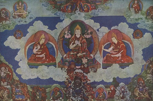
Another building at the monastery contained a prayer wheel, and a fresco portraying the trinity of deities (Jambeyang: 'The God of Learning', Chanadorje: 'The Holder of the Thunderbolt' and Shenrezig: the Dalai Lama) said to be represented by the scared peaks.
"An ever moving stream of pilgrims entered the little house, gave the prayer cylinder a complete turn, and then moved on, continuously circumambulating the sacred buildings."
Joseph Rock also notes that there were some nuns in residence at the Chonggu Monastery, although he says that these "lean, lanky toothless old creatures" had the same shaven heads and the same filthy clothes as the monks, and it was impossible to tell the nuns from the monks until they spoke.

As can be seen from his writings, Joseph Rock found the Chonggu Si monastery to be a disagreeable place - the smoky rooms and the stink from the stables sent him on his way earlier than he planned. He made a second visit to the peaks in August of the same year, but this was the middle of the rainy season, and he saw little in the way of mountain scenery. He had been planning to make a third visit, but was told by the Muli king that this would be suicide. There had been an unseasonal hail storm after his most recent visit that had ruined the local barley crops. This the bandits and outlaws had attributed to the mountain gods being angry at the visit by an outsider, and they had vowed to kill him on his return. Rock never went back to the Konkaling, "and thus the land of the Konkaling outlaws is again closed, and their mountains remain guarded as of yore."

In the 21st century, the Chonggu Si monastery is no longer the haven for outlaws, although some might say that the amounts charged for entrance fees and the horse rides amount to robbery. In the ten years since my last visit the monastery grounds have been tidied up and the unsightly shacks and filthy marquees used as makeshift accommodation have been removed. It s now all signposted and landscaped, and the monastery again plays host to a steady stream of visitors, but these days of tourists rather than pilgrims. Also since my last visit a large new temple has been rebuilt on the site of the ruin of the former temple. The previous chanting hall has been closed, but it bore some resemblance to the one described by Rock:
"I was led over a steep stairway to the left into a fairly good room - for that part of the world. It was the best the monastery could afford and was evidently the quarters of Living Buddha. The ceilings and walls were painted, and at the head of the room was a throne and a bed, above which hung some Tibetan scrolls, representing Tsongkapa, the founder of the yellow sect. To my left, a door led into a tiny private chapel, wherein reposed the tutelary demon of the Buddha. From below, juniper incense seeped into my glassless and paperless window and through every crack and crevice in the floor."
I paid another visit to Chonggu Si, and found the monks to be friendly, if a little bored of all the tourists trotting through their courtyard. They did not seem very other worldly.

During my visit the abbot of the monastery was doing his laundry outside in the yard using a cheap modern Chinese-made washing machine that was connected up to a generator, and which he filled with water by hand.

I had a look around at the freshly painted interior of the rebuilt temple, whose colours seemed so vivid compared to the faded and desecrated murals I found in the old prayer wheel room. These could have been the same ones seen and described by Rock.

So, Rock's small and dilapidated monastery is now larger and has a new coat of paint. And rather than being the remote haunt of bandits, it is firmly on the tourist trail, the centrepiece of one of Sichuan's busiest natural parks. Chinese tourists and trekkers arrive in their scores, and admission is now a hefty 150 RMB. So much has changed - even within the last 10 years.
Yading: first attempts
When I first started to do some research about the Konkaling peaks it was the pre-internet era of the early 1990s. In a climbing journal I came across a brief account of a 'reconnaisance' to the Konkaling peaks by a group of American climbers. I managed to track down the address of one of them, R. Dabney Eastham, who seemed to be an attorney in California, and he kindly wrote back to me with a long and detailed account of their trip in 1992, closely typed on several sheets of A4 paper. It sounded like quite an adventure into unexplored territory, even though they had a Chinese guide.
Like Rock, they had approached the Konkaling peaks from the east, via the then-closed village of Muli. They made it across the Shuiluo river canyon and to the peaks. They had tried to do a clockwise circuit of the mountains, but lost the trail and had floundered through snow and around cliffs until, disoriented, they eventually escaped to the west by following the course of a small creek. A second attempt a year later was more successful, and they competed a circuit, albeit in poor weather. They repotrted that the "Yading' area, as it had become known, was still very wild and undeveloped, and much remained to be explored.
My own first attempt to walk to the Yading peaks from Muli, in 1996, was a shambles. I'd hooked up with three Kiwi 'trampers' who'd read about my ambition to re-trace Rock's journey from Muli to Yading. We set off from Lugu Lake in mid March, to do a replay of my trek to Muli of two years before.

It soon became clear that we didn't get on with each other, and things gradually started to fall apart. My trekking companions were very experienced in New Zealand trekking but had not done much, if any, walking overseas, and it showed. Two of them insisted on walking in the 'short shorts' they were used to wearing in New Zealand. In the more conservative society of China, it just made them look like two old men who had lost their pants. A day after we set off from Lugu Lake, one of them let slip that he had not changed many New Zealand dollars into Chinese renminbi, and he only 300 yuan left. When we pooled or money, we found that we would probably have just enough to get back to Chengdu at the end of our trek, but not enough money to hire horses or a jeep if the need arose. I could have kicked him.
We retraced my earlier trek over the hills from Yongning to Muli, via Wujiao. It was still early spring and there was a bit of snow on top of the pass, where we camped. As before, we saw very few local people on this little travelled route.

On the way down to Muli, however, we did stop off at a Forestry Station, which was just a decrepit concrete shell of a building around which a few saplings were planted in rows. I told the manager that I had travelled along this same route a couple of years earlier and he smiled. "Ha! Old Mr Li the caretaker told us he had seen a foreigner walking past here two years ago and we never believed him! We though he was bulshitting us!"

At Muli we stayed at the monastery this time, in guest rooms where mice ran here and there over our sleeping bags while we slept. There was a visiting monk who had spent several years in Switzerland and could speak German but no English.
With no money to hire a jeep over the start point of Shuiluo, we tried hiking there. We followed a ridge up along a track that headed west towards Eyatong and crossed two high passes after spending two nights out up in the hills, while it snowed.

It took us two days to reach a remote village called Qunying, which was still two days walk from Shuiluo. By now we were exhausted, cold and fractious. The final straw was on the third day when we crossed another pass and found ourselves having to negotiate a sea of fallen tree trunks created by a large landslide. It was exhausting work trying to climb over one tree trunk after another, and by midday, with no end in sight, we gave up.


We worked our way back downhill to a logging camp called Baiyangping, where we were able to hitch a lift on a supply truck that took us over the ridge and back into the Litang river valley.

On the way over we caught tantalising glimpses of the Konkaling peaks in the distance, in all set in a grim and grey snow-laden landscape. We could see down into the Shuiluo river valley,but with weather conditions like that we would never have made it though and across to Yading and beyond. After three days slogging, we had barely made any progress.
Our attempt had failed due to poor preparation, lack of decent maps, and because we had gone too early in the year when the snows were still thick on the passes.
Second attempt
I was plagued again by snow on my second visit to Yading in 2002, even though this trip was made in the late spring season of mid-May. By this time, Yading had opened up and there were tour buses running to Daocheng from Chengdu via Kangding and Litang. I travelled this time with an older Aussie 'bushwalker', who proved to be just as inept as my previous Kiwi companions. In Daocheng we joined up with some Chinese trekkers we met on the bus to hire a minivan to take us into the 'national park'.

At that time, the Yading National Park was still in its infancy and there were few facilities at Yading or at the park entrance near Chonggu monastery. To cater for the increasing numbers of visitors, the monks at the monastery had erected a grubby old marquee tent and knocked up a couple of makeshift shacks from planks of pine, which contained a few camp beds and dirty mattresses. Another couple of ragged-looking marquees and wooden shacks had been put in further up the valley at Luorong.


Like most of the visitors at that time I did the standard 'tourist' trekker route, which comprised the inner kora (circuit) of Shenrezig. This was essentially a very long day walk over a couple of passes, starting from Luorong, going up past the two lakes (Wuse Hai and Niunai Hai) below Shenrezig to the first 'three-way' pass and then turning left to complete the circuit by going behind Shenrezig and returning to Chonggu Si monastery via another rather arduous pass.
I had travelled in May and was very fortunate in that I had a clear day for my walk, and got great views of all three mountains: Jambeyang, Chanadorje and Shenrezig, from the lakes area.


As is usual in these parts, the cloud increased by mid afternoon, and the crossing of the second pass was done in cold and overcast weather.

Towards the end of the afternoon we faced the final pass, which entailed a long slog up a zig-zag track under increasingly grey ad inhospitable conditions. We made it, to descend back down to Chonggu Si, where we found ourselves snow-bound by another overnight big fall of snow. Even worse, my Aussie trekking partner had developed snow blindness from failing to wear sunglasses on the snow the day before.

We spent a dull and frustrating day at Chonggu Si camp before deciding to walk out back down the valley to Riwa, since the road over the mountains to Chonggu Si was impassable due to the snow. From Riwa were able to hire a jeep to get us back to Daocheng, and from there we were able to get back to Chengdu.
I had experienced a taste of Yading, but there was still a lot of Joseph Rocks visit that I had not covered.
Return to Yading, 2010
So what made me go back? Well, I never got to see the other more remote parts of this mountain range that Joseph Rock described in his article The Holy Mountains of the Outlaws. He came in from the western side and did a full circuit of the three peaks, stopping finally at Chonggu Si before returning to Muli. I had really only seen the final part of his trek, that bit which lay in the (admittedly very scenic) Duron Valley. I'd always wanted to explore a little more and fill in the blanks.
Around Christmas 2009 I was thinking about making a return trip to south-western China. After ten years of on-again, off-again interest in the areas visited by Joseph Rock I had come to feel that I had 'been there, done that'. I had done Minya Konka, Muli, the Mekong and Kawakarpo areas and most recently I had been to the Salween. The only place I hadn't been to was the more northerly destination of Choni, in Gansu province, where Rock had spent a winter at the Buddhist monastery, preparing for an interesting but abortive attempt to reach Amnye Machen by following the Yellow River. This was my 'missing link', the last piece of the jigsaw in terms of 'collecting' Rock trips, but I wasn't very keen. I really wanted to see some mountains, and Choni area was relatively gentle in terms of hills. During one of my weekend saunters down Oxford St in Sydney I had popped into one of the many second hand bookshops (Berkelouw's, I think) and found myself leafing through an old book from the 1940s by the mountain climber and photographer FS Smythe. I was instantly transported into another alpine world of peaks, footprints in the snow, gnarled trees and glacier moraines. This is where I want to be, I thought. I wanted to be up high, in the clouds again.
In fact I really wanted to do a long-ish alpine walk, and really get away from it all - but where to go? At first I thought about doing the 'big' kora around Mt Kawakarpo (Meili Xueshan) in NW Yunnan near Deqin. This would involve crossing over from the Mekong to the Salween and then back again, and would mean traversing several high passes in a trip of about eight to ten days. A guy called Richard Scotford has guided trips on this kora and describes them here. It sounds great. But I had only recently been in the Salween (Nujiang) region and this would mean a return to almost the same place. So my thoughts turned to Yading. Surfing the web I found an account of a 'big' or outer kora of all three of the three peaks, written as part of a travel diary by a young American traveller and photographer called Lloyd Raleigh. He gave a vague but amusing account of this arduous trip, which involved crossing six or seven passes over a seven day period. He made it sound like fun, and the few photos he included on his web travel diary looked stunning - mountain peaks, alpine lakes, forest of spruce and fir trees and rhododendrons and some pretty rugged country. I decided to go.

The only problem was that I had no decent map of the area other than Lloyd's artistic sketch map, which was not to scale (and he had got lost and went off the proper route during his trek - hardly reassuring). Also, his track notes were not very specific, and were hard to follow because he referred to the mountains using the English translations of their Tibetan names - 'Wisdom' for Shenrezig, 'Power' for Chanadorje, and 'Compassion' for Chanadorje. Or was it the other way around? Whatever ... I had made my mind up to do the trip and pencilled it in for mid to late May. In theory, this was one of the best times to go. Joseph Rock says in his articles that late spring (May-June) and autumn (September-October) are the seasons most likely to provide the ideal conditions for travelling in western Sichuan and northern Yunnan. During winter the passes are closed by snow, and I knew from bitter experience that the conditions can be frigidly cold and bleak. In summer it is the rainy season, when the remnants of the monsoon rains sweep over from Burma and create drizzly and overcast conditions from late June to early September. So May it was.
I posted a message on this blog to announce my intentions, and said that I was looking for a trekking partner. Past experience has shown me that it's best not to travel alone in these parts, for safety reasons if nothing else. Within a few days I had a few tentative inquiries from around the world. An American guy doing postgrad research into tourism in China said he would be in the area and would be interested in coming along. Closer to home, I had an email from an old internet contact, Peter, with whom I had previously corresponded about treks in the Kham area. Peter was from Geelong in Victoria, and with a group of friends who were also keen bushwalkers he had already done some interesting treks in the Gongga Shan and Ganze areas of Tibetan Sichuan. From their photos they looked like real trekkers, with all the right gear, quite unlike my own makeshift attempts at being an outdoorsy person. Peter said he was also tempted by the prospect doing the 'big' kora at Yading, and was hopeful he could get some time off work. By a stroke of luck, he lived just around the corner from my auntie in Geelong, and a couple of weeks later while paying a visit to her I was able to drop by at his house to talk things over with him.
It's funny meeting someone else who shares an interest in a fairly obscure area. I'm normally used to the glazed expressions and bizarre, off-the-mark questions that emanate from people when I try and explain the attraction of trekking in western China in the footsteps of the plant collectors and explorers of the early 20th century. Peter, however, 'spoke the same language', and he had an impressive - perhaps even intimidating- aura of competence about him, quite unlike my own 'seat of the pants' approach to meandering in the mountains. We were soon discussing the finer points of how we'd go about the trek - he'd already looked up the route on Google Maps, and pulled up a great 3-D display of the whole route, complete with GPS points, courtesy of a Chinese guy who claimed on his website to have taken a mountain bike around the kora!

I shared a few of my dog-eared old paper documents about various aspects of the trip. Another interesting question he posed was why so few people were interested in trekking in this area of China. Modern-day would-be adventurers complain that it's hard to really get away from it all these days - the Annapurna Circuit is now all tea houses and paved roads. And yet the Kham area of China/Tibet is still unfrequented by westerners - why is that? Is it the language barrier? Or just a perception that China is overcrowded and polluted and too difficult because of red tape and regulations? Who knows the answer? Well, we didn't - but we parted with an agreement to meet up in early May in Chengdu.
Now, I’m 47 years old and not exactly a fitness fanatic. I don’t go to the gym or do any regular exercise or sport, so I decided I needed to get into slightly better physical shape to do this trek. For the six weeks before I embarked on the walk I started going for a run every day, eight laps around the local park football field, taking about twenty minutes – just long enough to break into a serious sweat. It wasn’t easy and it wasn’t pretty. I expected that after going through an initial ‘pain barrier’ period I would start to feel better and fitter, but that never happened. Every evening after work I dragged myself around the park, and every day it was just another tiring drag. If anything, I started to feel even more tired and worn out after several weeks of this. I just hoped it would be ‘alright on the night’.
For my tickets, I went to my usual travel agent - China Travel Service near Sydney's Central Station - and I was pleasantly surprised to find this time that I could get a return from Sydney to Chengdu, via Guangzhou, for a little over $1000. That was about $500 cheaper than my last trip. I put in my passport with them as well, to apply for a China visa, being careful to avoid listing my occupation on the application form as ‘journalist’ and instead putting something vague about working in publishing.
With my tickets booked, I then started thinking about what gear to take. After all my previous trips I have always always vowed to travel with as little as possible next time, but how can you ‘travel light’ when you are expecting to camp out in the mountains for up to seven nights?
I went out to the garden shed and dug out my hiking gear, much of it now 15 or so years old. My rain jacket had seen better days – when I hung it up readying it for a re-waterproofing I found that it had large tears under the arms, and the zips didn't work. My faithful and comfortable boots were in a similar sorry state of disrepair, with the soles looking like they were about to part company with the uppers. It was time for a visit to the canyon of Kent St, home to Sydney’s outdoor gear shops.
The next Saturday morning I trawled my way through Paddy Pallin, Kathmandu, Mountain Equipment, Macpac and the many other gear shops offering a plethora of equipment – much of which I had never even seen before. Water bottles, I discovered, were now an archaic tool from the past – the done thing in the 21st century is to take a camelback-style 'hydration system'. The one I was persuaded to purchase was allegedly designed for the Israeli Army and guaranteed not to become smelly because it repelled germs.
The gear shops of Kent St stocked an intimidating array of gadgets and appliances that I felt guilty for not bringing with me. Most of these items were exhorbitantly priced compared to what you would pay for their 'civilian' equivalents. Carbon fibre knives and forks for $50. Titanium cooking pots, $100 each. Walking poles. 'Second skin' dressings for treating blisters. And the clothing! Gone are the days when you can set off into the hills wearing a manly thick jumper, a lumberjack shirt and a tough pair of trousers - tweed or corduroy, probably (and not forgetting to tuck your trouser bottoms into your thick hiking socks). Now it's all about shells and layers, made of fibres that have the word 'poly' in them. And in pastel or dayglo colours. I fingered numerous examples of Gore Tex and other waterproof fabrics as I searched out a replacement rain jacket. One of the best was a sturdy-feeling coat I found in the Macpac shop, but it was only available in a shade of pinky-orange. Not wanting to look like a lump of bubblegum on legs, I instead opted for a jacket from Mountain Designs, mainly because it was the same reassuringly subdued blue colour as the one it was replacing.

As well as buying a new jacket, I also walked away with a new pair of Kathmandu hiking boots (one size too big as it turned out), a pair of those gossamer thin hiking trousers with zips that convert them into shorts, a new pair of high-tech socks and seven packets of Gordon Ramsay restaurant-priced freeze-dried meals, that promised to transform into delicious-sounding treats such as Mexican Chicken once water was added. (By the way, later on, when emptying out an old backpack, I found I still had a couple of these left over from a previous trip some years ago. The expiry date was 2006 –four years ago - but I tried one anyway and it tasted just like new - ie crap. I'm sure they're all made from the same ingredients, just with different flavourings added.)
New boots have to be broken in, of course, so the next day saw me on my run pounding round the park in my new outsize hiking boots, eliciting some very strange looks from the mums and dads supervising their kids at soccer practice.
The other essential items of kit for any Woodhead hike are books. I can’t spend several weeks on the road in China without something to read, but at the same time I am loathe to spend large amounts of money on books that I will end up discarding or giving away. So it was off to the Op Shop (charity store) to see what kind of $1 wonders I could rustle up. After passing on several copeis of The Da Vinci Code, for this trip the best I could find on the shelves was the autobiography of yachtsman Sir Francis Chichester, a collection of Jeremy Clarkson articles from the Sunday Times and pseudo-travelogue by a London writer Jenny Diski on her quest for silence and solitude in New Zealand and Finland.
Then it was time to think about food. On previous trips I had relied on those freeze dried meals for dinner and a combination of Vitawheat crackers and cheese for lunch. Not very tasty, but it worked. I should have stuck with the successful formula. Instead, I found some small tins of ‘ready to eat’ meals at the local Woolworths, which contained tuna or chicken mixed with pasta and vegetables (well, carrots and beans). They looked quite tasty and handy, so I bought six, thinking they would suffice for lunch. I also allowed myself six Snickers bars for energy. For breakfast I bought a big bag of my favourite muesli and got some milk powder in a ziplock bag.
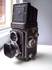
The other major item to fill my backpack was camera gear. Being one of the last people in the world to still prefer using film over digital, this meant bringing a large bag of film canisters, as well as three different film cameras. With a collection of more than ten film cameras – all of which I am passionately attached to - it was hard to choose which ones to bring.
In the end I settled for my big Rolleicord medium format camera, the Leica M2 as the mainstay, and a small Nikon 35Ti ‘point and shoot’ for slide film. Altogether I packed about 70 rolls of 35mm film (Kodak 400 print film and Kodak E100 G Ektachrome) and 12 rolls of Ektachrome 120 film.
When I put all this plus my spare clothes, sleeping bag (a Mont 3-season), Thermarest and tent (a Walrus one-man lightweight job) in the pack it clocked up almost 20kg on the bathroom scales. Oh dear. I decided it would be a good idea to have a trial run to see if I could manage such a heavy load, and also to check out all this new gear to make sure it all worked.

A couple of weeks later I took my 10-year old son Paul on a practice walk - a gentle overnight trip to the camping ground at North Era beach, in the Royal National Park south of Sydney. After a lovely apple pie and cream to start us off at the café near Otford, we set off along the clifftop track and down through the ‘Palm Jungle’ to Burning Palms beach and beyond. As well as being a pleasant interlude, the trip taught me a few valuable lessons - I discovered that the rain jacket was very sweaty and very fiddly to zip up, my boots were too big (more thick socks needed) and my backpack sat uncomfortably low on my back and I kept trying to hitch it up. My food choices seemed OK, but the trip also reinforced the fact that I would need to be carrying a lot of water – we consumed two litres in just a few hours of relatively easy walking.
Back at home, after a few last minute purchases and adjustments, I was now ready to go. All I had to do now was wait those last few weeks and days. And oh, how slowly they seemed to tick over. "Big trip coming up - are you excited??!" people would ask me at work. Well, no, not really. More worried about what might go wrong. And as I was to discover, plenty of things would go wrong.
Yading – Getting there

I flew out to Guangzhou from Sydney on the morning of Friday 7th May on a China Southern Airlines flight. I took the train from Strathfield to the airport via the city. It felt so funny to be on my usual morning train, squeezed in among all the commuters with my heavy backpack. ‘You’re going to work and I’m going to China,’ I thought, gleefully. At the airport, once I’d checked in my bag, I had that feeling of elated anticipation. It’s all on now. But what is it about air travel that makes you do things you wouldn’t normally do? Spending large sums of money on things like magazines you wouldn’t normally read, just because you’re going on a long trip?
The flight itself wasn’t too bad, though once I arrived in Guangzhou, things started to go wrong. The plane was delayed and my bag went AWOL. They’d checked my backpack right through to Chengdu, and I felt uncomfortable leaving it circling round on the luggage carousel at Guangzhou, as staff assured me that it would be sent through on my connecting flight. Then I found that my connecting flight would be five hours late, so we wouldn’t arrive into Chengdu until after midnight, local time (about 2am my time). And of course I ended up being the last person in the arrivals lounge at Chengdu before it shut down for the night, maintaining a lonely vigil for my bag at the carousel, which eventually stopped. I was ushered into a back room and given lots of forms to fill out, and told that my bag had been held up by customs in Guangzhou. It might arrive in a few days time. Disconsolate and very tired, I took a dodgy taxi into the city and checked into my old standby, the Traffic Hotel. I had to wake up the receptionist in the early hours, but she didn’t seem too bothered, and soon had me sorted out with a dorm room for 40 kuai.

Things looked a little better in the morning. The hotel still had an archaic dining room where I ate alone, hovered over by three young waitresses, delivering my special 10 kuai ‘western breakfast’ – a fried egg on top of a slice of sickly cardboard white bread, and a glass of orange juice. At least they did something resembling coffee. I took a walk around Chengdu and it was pleasant shirtsleeves weather. More skyscrapers, including a whole new development designed by some Italian architect I’d never heard of, that promised to be a major outlet for Prada and Louis Vuitton. I took a walk up to the Bank of China and was told they could not change Australian dollars until Monday. Just as well I’d changed a few hundred kuai before I arrived.

Peter was due to fly in that afternoon, so I went out to the airport to meet him, and also to ask about my missing bag. The good news was that the backpack had turned up on a later flight from Guangzhou, and my ‘worst case scenario’ fears about having to buy a load more new camping gear were never realised.
I went to the bus station next door to the Traffic Hotel and secured us tickets to go right through to Daocheng for 240 kuai, leaving on Monday. Sunday would be a day of rest and ‘cultural acclimatisation’ in Chengdu. We went out for a curry that night at an excellent and very popular Chinese-run Indian restaurant further along the riverbank.

It was good being back in China. People in Chengdu seemed friendly, things worked efficiently, and it was a buzzing, modern city.
I spent much of Sunday traipsing round the outdoor gear shops down the road from our hotel. It was interesting and mildly annoying to see that had much the same gear as I had seen in Sydney, but for about one third of the cost. Much of it was Chinese made, but none the worse for that – it looked to be just as good quality as much of the stuff on sale back home.
After getting soaked in a Chengdu downpour, I found that my rain jacket worked fine (and no longer seemed so clammy), but my trekking trousers were very quickly sopping wet. I opted to buy a pair of lightweight waterproof hiking trousers and a new pack cover. That night we went out to a Chinese Muslim restaurant in a distant district. It was a wonderfully chaotic place, running by a big matriarchal boss woman who barked out orders to her young male helpers as they brought us the house speciality – chicken with potatoes (dapanji) – to our table. The place was really popular with Chinese diners and despite being Muslim sold Snow Beer.
The bus strip to Daocheng took two days, with an overnight stop in Kangding. After the usual rigmarole of getting everyone in their assigned seats, we set off at 10am with much signing of forms, and then immediately stopped on the next street down from the Chengdu bus station to pick up a few unofficial passengers, who sprawled wherever they could find somewhere to sit - in the door well and on top of the gear box. The bus covered what was now well-travelled territory for me - the motorway to Ya'an, a brief stop for lunch at the usual scruffy restaurant with filthy looking kitchen (but delicious food), and then the start of the big grind up through the canyons and over Erlang Shan to the Dadu river and Luding. Yet again, more evidence of construction on a massive scale. A new road now bypasses the centre of historic Luding and its famous metal chain bridge, and instead skirts the town and passes what looks like will be a major hydro dam, complete with massive tunnels through the side of the mountains. I passed the journey reading a dull autobiography of Kate Hepburn and swigging on my newfound favourite drink - bottles of lemon tea.

We arrived in a very dark and rainy Kangding in the late afternoon and were told by the driver to prepare for a 6am start the next day. The new bus station was at the very far end of town and we didn't fancy a long early morning journey back from our intended hotel - the Black Tent Hotel, so we managed to wangle a room at the 'foreigners not allowed' bus station hotel. It was just as well that we did, because when we did walk all the way up through the town we found that all the old wooden houses and buildings at the top end of town were in the process of being demolished - including the Black Tent Hotel and even the forecourt of the next door Anjue Si Buddhist monastery. I thought of the many times I'd spent in the cold bedrooms of the Black Tent Hotel, and of the interesting characters I'd encountered there. All gone now.

Next door at the Anjue Si, as we surveyed the wreckage a monk came out and asked us where we were from. When we said Australia, he said "Australia good, Beijing bad," and started complaining about how they had no idea what would happen to the remains of the temple. The actual temple itself was still intact, but the monks' living quarters were already gone. A young monk sauntered through the demolished area, blowing a conch shell and it all felt very disconsolate.
We walked up the hill to check out a new hostel we had heard about - the Zhilam Hostel, supposedly run by an American couple in an effort to encourage hospitality industry skills among the local Tibetans. After a short but steep climb up the paths behind the Kangding Hotel we found the hostel, unsignposted and locked up. A note on the door said the American couple had returned home for medical treatment and the local manager was also sick - so the place was temporarily closed ('perhaps due to the stress of running a hostel in China'). We spent the rest of the evening in a new cosy bar that we found outside the Kangding Hotel. It had funky furniture and a charming if slightly incompetent waitress who tried to sell us Budweiser according to the volume rather than by the bottle. She later came over and apologised, saying it was only her first week in the job - and in town - and she was still unfamiliar with everything.

We thought we'd be the only ones making an early start on Tuesday morning, but at 6am the still-dark bus station forecourt was chock full of coaches with engines running and passengers boarding for places such as Ganze, Danba, Litang and Chengdu. It was just getting light as we pulled out and headed up the road west, to traverse the first of several passes we would cross that day. The Zheduo Pass was snowbound, although the road was clear, and beyond it we had really entered the Tibetan world.
The houses were Tibetan and we saw yaks dotting the moorland-like landscape, which also had regular arrangement of prayer flags fluttering in the strong highland breeze. This was the Tibetan plateau, with Chinese characteristics. The first was a huge American-style advertising billboard at the top of the pass, promoting the tourism potential of the area. We were to see many more such billboards, promoting concepts such as the 'green corridor' of Kham, and the unity between the army and people of the district. Another noticeable new development was the number of backpacker lodges being advertised en route.
Almost every Tibetan settlement we saw had a sign outside that included the Chinese characters for beibao (backpack) and guesthouse (kezhan). We soon saw why. Every few minutes, strung along the main highway we saw groups of Chinese cyclists pedalling the punishing miles along this main Sichuan-Tibet route. They all looked well equipped and serious, with rain gear, panniers and spare tyres festooned over themselves. It was a long way to Lhasa and I admired their tenacity - but I'm not sure I'd want to emulate their ride, along such a busy road along which they would have to contend with big trucks, coaches and badly-driven Range Rovers.

Beyond Xinduqiao and Yajiang the road became a switchback over another pass - or was it two - and we shared the road with a large convoy of slow-moving tuolaji tractors that seemed to be ferrying Tibetan families and large amounts of their luggage on a pilgrimage, either spiritual or economic. On we went to Litang, at around 4000 metres, where we made the briefest of stops at the bus station and saw a couple of English guys who had been stuck their for two days trying to get a ride down south to our destination of Daocheng, and beyond. We wished them luck and continued on our way, heading south now, over the rocky plateau towards Daocheng.

The last time I visited Daocheng it was something of a backwater, a one-street town with just one decrepit official hotel for foreigners and a couple of colourful Tibetan guesthouses. Now the whole main street was lined with guesthouses and we were besieged by touts as soon as we got off the bus, offering to take us to the 'official' YHA youth hostel, or one of several other trekker's hostels. Other Tibetans crowded in on us and offered private transport to Yading. At least it looked like we'd have no problems getting there!
Ignoring the touts, we walked across the road and discovered a wonderful and cosy cafe-cum-guesthouse, the 'Here Cafe' (Gaoyuan Kezhan, or Plateau Youth Hostel), set up by a delightful young Chinese couple in a converted Tibetan house.

The couple, Yang Na and Xiong Ke, had moved from Chongqing and created a very homely and relaxing trekker's lodge in this otherwise austere little town. We looked longingly at the comfy sofas and were disappointed to hear that their dorm rooms were already full, but they quickly arranged a room for us in the 'overflow' next door, run by a lovely friendly Tibetan woman who ran the adjacent little wooden kiosk shop. When we mentioned that we were planning to spend a whole week or more at Yading, Yang Na gasped and said - "Oh, are you Michael? Doing the kora? An American guy called Travis has been hanging around here waiting for you ..." Small world indeed.
She told us that 'Travis' had moved on to Yading, and we would no doubt run in to him at the guesthouse there the following day.
After shedding our big packs, we had a quick look around town and dived into a small restaurant for something to eat. The great thing about restaurants in small Chinese towns is that you can just walk in and ask the owner to prepare whatever you fancy. No need for menus. They invariably have the raw ingredients such as beanshoots, vegetables and mushrooms on display on the shelves, and the meat is in the fridge.

In this case, we asked the lady to stir fry us some pork and peppers and also some mushrooms and tomatoes. "No. Better the other way round," she replied. "Pork with tomato, mushroom with peppers." And so that was that. One day someone will open a DIY restaurant in Sydney like this, and it will be a huge success.
After the shirt-sleeves weather of Chengdu, Daocheng was cold. Very cold. I had been banking on buying some kind of thermals in China, but the Daocheng shops had little on offer. There were several selling all manner of Tibetan paraphernalia such as beads and incense from India ('Export Quality'), but when it came to warm clothing the best I could manage was padded waistcoat trimmed with imitation fur. It would have to do.
Back at the Here Cafe we settled into the cosy chairs and sipped our Snow Beers. Xiong Ke, the slightly boho co-owner, told us that he had done the kora a couple of years ago and we shouldn't have any problems finding the way. We wouldn't even need tents, he said, because there were yak herders huts along the way. His beautiful partner said it would be a nice alternative to the now over-developed main valley. "They have golf buggies running up and down the valley now to carry tourists," she said, in American accented English. Golf buggies? Well, electric powered carts. Aiyah!

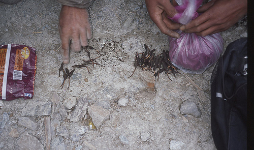
There were only two problems with our proposed kora trip, said Xiong Ke. Firstly, it was the wrong season for doing the kora - most Tibetans did it in October, when the weather was milder and clear, not in May when it could still be cold and icy or cloudy. The more pressing problem was that it was now the 'congcao' (pronounced Chongtsao) season. The congcao - or awato - is a strange kind of fungus that develops inside the carcass of a caterpillar buried just under the surface of the soil, and it is greatly prized for its medicinal and rejuvenating properties. A single congcao can sell for hundreds of kuai in the big cities like Shanghai, and Tibetans sold them for about 25-30 yuan locally. They were only in season in the last few weeks of May, and during this time Tibetans emigrate en masse into the hills, where they can be seen rummaging through the topsoil with small metal hoes, digging up the fungus. During this time few Tibetans would be interested in breaking off this lucrative activity to earn 100yuan a day for guiding western trekkers, said Xiong Ke.
The next morning, after an amazing Yunnan coffee, Yang Na and Xiong Ke set us up with a reliable driver, and he was given instructions to take us to the same guesthouse where Travis, our mysterious would-be co-trekker was staying. After a breakfast of xiaolong bao (small steamed bread buns with meaty fillings) we embarked in a tiny minivan driven by the portly gruff Tibetan, who wore the typical off-the-shoulder Tibetan cape and even kept his cowboy hat on throughout the drive. Aside from offering to take us on the kora himself, he said little on the two hour journey over the hills to Yading. We passed through what had once been Riwa township, but which has now been confusingly re-named 'Shangri-La', in the same way as the much bigger town of Zhongdian in Yunnan has adopted this tourist-friendly moniker (Xiangelila in Chinese. Then we reached the entrance to the Yading National Park, where we had to pull in to a major gatehouse complex and carpark to purchase our Y150 park entrance tickets. It was here that we ran into Travis, who was travelling as a passenger in a beat-up Landcruiser, accompanied by a rather slick young Chinese woman wearing a purple coat and knee-high boots. He was a tall, rugged blond-haired guy who looked like he'd just hiked out of the mountains of his native Colorado.
Travis introduced himself to me and said that he had been hoping to accompany us on the trek, but he had developed a really bad chest infection in the last week and it was refusing to go away despite being blasted with every antibiotic the local hospital clinic could throw at it. So, regretfully, he was going to have to pass on the chance of doing the kora this time around. He would however, be basing himself in Yading for a while as he was working on a PhD thesis on how Chinese tourism was developing. We drove on together and soon arrived at Yading, where our driver deposited us at a very un-promising looking building site around an old Tibetan house that had a sign outside proclaiming it to be the Dengba Guesthouse.

The owner, a rather diffident young Chinese guy from Anhui, apologised for the mess, and said the rooms would be ready by that evening but were still being fitted out with bedclothes and basic furniture. We took his word for it (with Travis' reassurance that this was the place to stay) and went for a walk around Yading. Almost every building in the tiny settlement of about ten houses had been turned into a guesthouse of some sort (even one called [Joseph] 'Rock's Rooms'), but we appeared to be the only tourists in town. The only other people about were groups of friendly old Tibetan grannies and granddads, and lots of snotty-nosed Tibetan urchin kids. No shops, and no restaurants.

The other major thing we realised about Yading was that the actual entrance to Yading National Park was way down below in the bottom of the valley - about 500 metres lower down and a good mile's walk away.
On this our first day at Yading, we went for a 'familiarisation' walk down to the park gate and then an hour's walk up the valley to Chonggu Si monastery. Going down was a drag, but once we got past the gatehouse and the many Tibetans offering houses for hire, I realised that I was seriously unprepared for the high altitude.
Even the gentle incline of the gravel track up to the monastery soon had me rasping for air and stopping for regular rests to get my breath back. We had come up almost directly from sea level to 4000 metres and it's no wonder that we were left floundering like fish out of water. Along the trail we encountered quite a few Chinese tourists who were rising horses up to the monastery. Some of them had brought along aerosol bottles of oxygen. I didn't think I would have to go that far - but it didn't bode well for our plans to be hiking at much higher altitudes, carrying a 20kg pack.

The trail up to Chonggu Si had been upgraded and signposted since my last visit. Past the 'Dongle Bridge', a musical toilet block and many mani stone cairns, I found the monastery had changed for good and for bad. On the positive side, the rickety old shacks and dirty marquee tent accommodation blocks had been removed, making the place look neater. A large and ornate new chanting hall had been added to the group of buildings, on the site of an old ruin. However, the area around the monastery had been developed into a dire 'tourist reception area' eyesore. Where there had once just been a gravel track leading up the valley to the Luorong pasture, the park authorities had now installed a wooden walkway. Nothing too much wrong with that. But alongside this they had also laid an ugly winding ribbon of concrete road all the way up the valley on which a fleet of 'golf buggy' electric cars plied back and forth carrying tourists to Luorong for 80 a head, while playing tinny Chinese and Tibetan tunes from loudspeakers.

This 'bullet train' as we termed it, had a terminus area complete with ticket office, 'police station' (a bare room with a heater in it), 'clinic' (a bare room with a bed in it), concrete assembly area, garage and even a few rows of modern toilet cubicles. We peered into a few of these toilets and they were all blocked and disgustingly fouled up - one even had a pair of men's underpants left behind on the floor. Why does China - which boasts of having a 5000 year old civilisation and has put an astronaut in space - have such problems maintaining even the most basic toilet facilities?
Walking back down the hill to the entrance, I asked around among the horse-for-hire Tibetans about the prospect of hiring someone to guide us around the mountain. Some said it could not be done, some just shrugged or laughed, but one big young guy pushed himself forward and said he had done the kora and he would be willing to take us round ... but it would take ten days and would cost a lot of money. I decided he was bullshitting, and said thanks, but we were no longer interested. He became more persistent, however, and pushed his case quite aggressively, as he followed us further down the hill. He was to prove difficult to shake off. When he did eventually break off, he said he would come and find us that evening to discuss the trip further and he warned us - "if you come back to hire a guide, make sure you ask for me first!" Eek!
From the gatehouse, the walk back up the hill to our guesthouse nearly wiped me out. It was only a gentle gradient on the road, but the long slog had me panting for air and experiencing heart palpitations. Peter took a couple of steep short cuts that avoided the long switchbacks of the road, but I failed miserably when I tried these. By the time I had reached the guesthouse higher up an hour later, my confidence was seriously dented. How could I even contemplate hiking in the hills if I couldn't even manage a gentle road walk without a pack on? Maybe I needed a few more days to acclimatise to the altitude.

Back at the guesthouse I realised I would also need some time - and more clothes - to acclimatise to just how cold it was. As soon as it got dark the temperatures plummeted and even with five layers of clothing on I was still shivering around the table in the communal 'dining room' of our guesthouse. The guesthouse owner arranged for everyone to eat together. He had recruited a volunteer helper - a young kid from Guangzhou - who received free board and lodging in return for helping about the hostel and coking dinner for everyone. He produced a wide variety of dishes - tofu, pork, pepper, and scrambled eggs with tomato, mushrooms - all delicious. We shared this with a group of female trekker types from Guangdong and one from Hainan Island who buzzed around chattering away as if on speed. Travis told us about his academic studies into tourism and his life divided between Chengdu, Beijing and here 'in the field'. A former Peace Corps volunteer, he talked with us about books on China, and he revealed he was an old friend of another former Peace Corps worker Peter Hessler, now a famous China-based author and journalist. His companion was not his girlfriend but a female tourist from Shanghai who had also wanted to visit Yading. "Angela' seemed an unlikely enthusiast for the great outdoors. Her purple jacket was matched by purple-tinted contact lenses, and she had brought along her hairdryer, which she used noisily before we ate dinner. She spoke in staccato matter-of-fact Shanghai English, and seemed determined to enjoy her visit to Yading and to see all the sights.
We also shared the guesthouse dining room with a couple of earthy carpenters from near Chengdu. They were just visiting, making a set of tables and doors for the manager, and their accents were near incomprehensible to me, but Travis got along well with them and poked fun at them and their eating habits.
With only a small heater to warm the room, we soon retired to the double eiderdowns of the bedroom. I didn't sleep well. The high altitude had me waking suddenly, gasping for air, and the dryness of the alpine air also resulted in me waking up at regular intervals with a terribly parched dry mouth and cracked lips.

We were to spend two dull and frustrating days at Yading like this, waiting for the weather to clear. Each morning we would wake early, at about 6.30 am and rush to the window to look and see if the view of the mountains had improved.

On each day we were greeted by the heart-sinking sight of mountains shrouded by low cloud. We made further trips up the valley, to visit Luorong on the 'bullet train', and again the weather was overcast and apart from a few brief glimpses, the peaks were mostly hidden behind cloud.

The Luorong area was now criss-crossed by wooden walkways and even had a hanger-like building to house the bullet train buggies. There were still fine views of Jambeyang, but the valley floor was now home to several new log cabins and shacks used by the horse hire gangs, who hung around pestering all visitors to ride a horse up to the lakes. It all felt a bit tacky.

We ventured higher up to the two lakes, paying an extortionate 300 kuai to hire horses to take us up there. The journey took only an hour or so, and we were only allowed to ride the horses on the flatter sections - the rules stipulated that we had to dismount on strenuous steeper stretches of tracks. Up at the lakes it was blowing a gale and small but hard pellets of snow were falling - more like hail really.
On the way back we looked for the start of the trek. According to Google Earth, it should have been easy to spot the large gully that leads up to the north between Chonggu Si and Luorong. In reality, the thick covering of trees at ground level made it less obvious. There was a gully, but no obvious track up it. The GPS said this was the right place to start, but it did not look promising. We really needed a guide to show us the way.
We went back down and tried negotiating for guides and horses again, and each time we got wildly different answers. "You can’t do the kora, the snow is too deep on the passes." "It's too windy." "The route is impassable for horses" "It will take you two weeks." "We will only do it for 400 kuai per day ..."
We asked at the guesthouse, but a local man who was deemed reliable and trustworthy by the owner told us that the kora was too difficult for horses and that nobody would be willing to act as route guides (xiangdao) during the congcao season.
With no serious takers for our kora guiding proposal, we switched tack. We had met some Chinese trekkers who had come over from Muli, and they said there wasn't too much snow up on the high pass. So we asked some local Tibetans if they would take us just over the first pass and on to Garu, a village on the other side, en route to Muli. Only two days instead of seven.

Down at the park entrance, the 'horse hiring' manager called us into his office and sat us down. Dorje, as he was called, had the air of a big boss in a multinational corporation. "Look" he said conspiratorially.” I have heard about what you want, and it can all be arranged. Horses, guides, everything. You leave it all to me, OK?" We told him we wanted to leave the next day. "No problem. I will come to your hotel tonight to finalise the arrangements. From now on, you don't talk to anyone else about these arrangements. Clear? Don't talk to these young local punks, they will promise you anything, but they haven't a clue. Alright?" We agreed, and returned to our guesthouse full of hope for the next day. But Manager Dorje never showed up.
On the fourth morning at Yading we woke up and saw the weather was again looking grim. Whatever. We were getting cabin fever. It was time to do something, even if it just meant tackling the first pass by ourselves. We packed our bags, said farewell to Travis and hitched a lift in the beat-up old Landcruiser belonging to the guesthouse manager from Anhui, and we went down the hill to start our trek.
Trek Day 1: Chonggu Si to Garu Pass
It was a relief to get away from the Yading guesthouse after almost four days there, especially as the pipes had frozen and cut off the water supply to the toilets, which now stank to high heaven. We went down the hill at 8am and found the usual crowd of Tibetan horse handlers sitting around the gatehouse area. We went into manager Dorje's office and asked if he was still able to help us out with guides.
"No problem, no problem, just wait outside," he said, waving us away.
Ten minutes later he came out and said he had arranged two guides for us, at a cost of 200 kuai per day each, to take us over to Garu and on to Lugu Lake, if we wished.
"What about horses?" I asked.
"Ha! Horses can't make it! The track is too steep," he snorted. "You can only take guides - they will carry your bags for you." And the two guides he had selected were already familiar to us.

One of them, an older guy wearing a cowboy hat, had been clowning around with us the day before as I took his picture. He had asked me to send him a camera, as he didn't have one. His name was Wangdu. The other guide was the pushy and sullen guy who had been pestering us to hire him two days earlier. It didn't look like we had any choice but to hire him. His name was Dorje.
Before we set off, I sat down with both of them and thrashed out the deal. I didn't want any unpleasant extra charges or changes of plan later in the trek.
"OK, you will take us over the pass to Garu, and we will pay you 200 yuan a day for the two day trip and also two days pay for you to make the return trip. Understood?"
The sullen one agreed, but the older guy spoke up.
"Actually, it will only take us one day to return, so you only need to pay us for three days," he said, in an amazing and reassuring display of honesty.
And so that was agreed. They went off 'to get some supplies' for the trip and we waited in an almost festive atmosphere as the other Tibetans sitting around chatted about us and our trip.
Presently, Wangdu and Dorje returned with a small sack about the size of a shopping bag. That was the sum total of their supplies.
"Won't you need sleeping bags and food?" I asked.
"No need. There will be places to stay on the way. There will be people living up there," said Wangdu, pointing with his chin and lips in the Tibetan way up at the hills.
And without further ado they shouldered our packs and we set off, up the tourist track on the first stage of our trek. There were a few farewells to the assembled crowd, and then we were on our way.

After only ten minutes of walking, however, there was a lot of commotion and Wangdu turned around and put down his bag, to walk back down the hill. "Just a moment, won't be long ..." he said, as he disappeared into the distance.
He returned about ten minutes later accompanied by a young Tibetan woman with striking features, who I had noticed yesterday. It was his daughter, and she had insisted on relieving her father's load and carrying one of the bags at least as far as the monastery.

Once again, we were on our way, but we didn't feel very adventurous. Here we were walking up a signposted tourist trail, which we shared with Chinese day trippers who sauntered past on horseback, bidding us good day with a "How Are You?" or "Ni Hao!" greetings. My bag was being carried by a young woman and I was already sweating and struggling for breath. Not an auspicious start.
On reaching the 'bullet train' terminus Wangdu took the backpack from his daughter and said a cursory farewell. We set off once more, this time along the concrete track and I expected that we would hike the mile or so up to the gully before heading up the mountain, so it was a surprise when we almost immediately left the concrete road and followed a small footpath that meandered up into the thick forest that surrounded the trail. It was only a few hundred metres on the left from the Chonggu Si terminal, and if you are looking for it, then be advised that it forks off well before a set of picnic tables.
The track lead up through the forest, which was a mixture of larch and fir lower down, and rhododendron (with pink flowers) higher up.

Within minutes I was floundering. Every step upwards left me gasping for breath. It was as if I had just run a 100 yard sprint and was trying to get my breath back after reaching the finish line, bent over, hands on hips to try get more air into my lungs. I tried all my old high altitude trekking techniques. Counting breaths, 1-2-3-4, counting steps, stopping every ten paces, and setting myself little goals such as reaching a rock a few yards ahead ... none of it seemed to offer any relief from the unrelenting 'instant exhaustion' that befell me as soon as I put one foot in front of the other. The constant hyperventilating and the rapid beating of my heart left me worried for the strain it was all putting on my body, not to mention the nausea and faint headedness I was feeling. After an hour I was considering packing it all in. I felt like death and I was falling further behind the others as I took more and more rest stops to regain some kind of control of my breath.
Somehow, I managed to carry on, taking baby steps and bending over like an old man, crawling at snail's pace up the trail until we reached the end of the tree line and emerged from the forest into open hillside. Here the track levelled out and we could see how our little path had been a short cut that connected up with the large gully. We were on the right track.

As the trail contoured around the side of the hill into the massive gully, we gained sweeping views of the Luorong valley below us, and in particular the unsightly white line of the 'bullet train' track. As we continued up the valley - we reached a basin beneath some prominent red rock turrets. On the flat grassy area were a couple of stone hut shelters. This was presumably the camping site that Joseph Rock referred to as Bayu in his account of his 1928 trip, situated in the Shindze Valley - the gully we were travelling up.

Whereas for us this was the first leg of the trip, for Rock, this was part of the final leg of his journey around the mountains, after he had spent three "most disagreeable nights" at the Chonggu Si monastery, plagued as he was by smoke, filth and ammonia-like fumes from the adjacent tables.
This is what he wrote:
"We left on the final lap for a pass up the Shindze Valley. There we camped at 15,800 feet, where we could view both Jambeyang and Shenrezig to the best advantage should weather conditions permit. We spent two nights at this high camp, called Bayu. The second morning, with a temperature of 40 degrees Fahrenheit on June 26, my lama [guide] awakened me at 4.30am, calling into my tent: 'Behold the glory of Jambeyang and Shenrezig - your luck indeed was great!' I rose and stepped into the cold grey morn. In a cloudless sky before me rose the peerless pyramid of Jambeyang, the finest mountain my eyes ever beheld. The sky was greenish black. The snowy pyramid was grey, but the apexes of both it and Shenrezig suddenly turned a golden yellow as the sun's rays kissed them."
It's interesting to speculate whether this description of Jambeyang by Rock inspired James Hilton's description of the sacred mountain of Karakal in his book Lost Horizon, that gave us the notion of Shangri-La:
"It was to the head of the valley that his eyes were led irresistibly, for there, soaring into the gap, and magnificent in the full shimmer of the moonlight, appeared what he took to to be the loveliest mountain on earth. I was an almost perfect cone of snow, simple in outline as if a child had drawn it .. it was so radiant, so poised, that he wondered for a moment if it were real at all.
The mountain showed again, great at first, then silver, then pink as the earliest sunrays caught the summit."
Our luck was not so great and weather conditions did not permit such rapturous visions. Instead, opposite us across the valley we could see the huge grey limestone razorback ridge, which I recognised from Joseph Rock's photograph of the site.
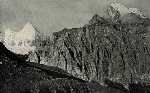
In his picture, taken on a clear day, both Jambeyang and Shenrezig were visible from this point, but we could see neither of them, as their summits were obscured in the low cloud.

Nevertheless, it was a nice place to take a break, and we ducked into one of the stone shelters to have lunch. Inside it was cold and dark, but at least we got some shelter from the wind. And at last I was lightening my load by consuming some of the supplies I had brought all the way from Australia. I had the first of my tuna and past ready-to-eat meals from a tin, and it didn't taste too bad, if a little oily.

Then it was onwards and upwards, and the going didn't seem as bad as it had in the morning. The landscape was bleak - brownish moorland and rocky outcrops, as we ascended towards a plateau surrounded by dark rocky ridges. I had been worried about this first pass because, at over 16,000 feet, it was the highest we would have to tackle. So far, however, it didn't seem to be too hard. We ascended from one plateau to another, and the weather deteriorated as we got higher.

The wind blew very hard, but fortunately it was blowing from behind us. We were also bombarded with small particles of snow, almost like polystyrene balls. As we ascended a further false ridge we heard faint whoops and cries, and came across two Tibetans out gathering for congcao. They hailed us over and we sat down together for a longer rest as the fungus gatherers conferred with our two guides over a cigarette.
The pass now appeared to be quite close, and we had reached a final plateau surrounded by sinister black ridges of rock. The track was marked by a series of small cairns and as we continued on up we saw what looked like the pass at the head of a shallow incline. We had made it to our first objective!

When we reached it, the pass was marked by the usual cairns and strings of prayer flags, many of which were in a very ragged condition because of being battered by the high winds and rain at this altitude. The pass was relatively level, and nestled beneath a large outcrop of flat, slate-like schist.

We didn't hang around for long because the bitter cold wind was blowing hard, urging us on, to start the descent in the direction of Garu.

Over the ridge we were confronted by a grim and empty landscape of more jagged rocky ridges, black peaks jutting into the mist, and grey rock buttresses running into the distance. The track threaded down through the open tussock grass and made a relatively gentle descent. So much easier going down!
We plodded on down, with a massive high grey solid rock ridge emerging on our left hand side. On top of the ridge a few boulders perched precariously - one in particular looked like it had been placed there by a giant and would need only a slight push to set it rolling down the precipitous slope.

We were in a good mood on the way down and Peter and I noted that there had been none of the snow on the passes or steep slopes that we had been warned about so much by the naysayers back in Yading. If the highest pass was free of snow, we reasoned, the remaining lower altitude passes on the kora should also be open. So why don't we try for the kora instead of Garu and Lugu Lake?

On our next rest stop we put this proposal to our guides, and offered to pay them the same rate per day for taking us around the mountains instead of down to Garu. For a six day trip, this means they would get 1200 RMB instead of the 600 RMB they were expecting for the trip to Garu.
They agreed without demur, but said they would have to 'stock up on supplies' at a settlement further down the valley. They said there were 'people living up here' collecting congcao, but we could see no sign of anyone for the next hour or so. All we saw were a series of ridges extending to the horizon, in the direction of Muli.

However, in the late afternoon as we rounded another corner in the hills, we were suddenly confronted with a veritable mini-metropolis of makeshift stone huts sited in a natural basin. There must have been about twenty such huts, many emanating signs of smoke from cooking fires. Some had slate roofing, others were covered with heavy plastic sheeting held in place with heavy stones.
As we approached closer we heard the sounds of smashing glass, and spied three young kids playing on a large pyramid of empty green beer bottles, which they were smashing by throwing rocks at them.

"This is where people come up from the valley in May to dig for congcao," explained Wangdu. He seemed wary about approaching the huts, as they were populated by Garu people, a different tribe to his Yading brethren. I could understand his wariness - there had been a long series of local disputes over grazing rights and gold panning rights between the various peoples of the Konkaling.
Dogs were tethered on chains outside some of the huts, barking at us, and one or two people wandered about this temporary township city in the hills, but paid no attention to us. A few yak grazed on a flat section of turf and there was even a little store, complete with a snooker table. How had anyone hauled a snooker table up into these mountains?
After seeing its shopping and cultural potential I dubbed the settlement Hammersmith. Like its London namesake it had a Palais [of sorts], and now there were white men in it.

Wangdu introduced himself to the tough-looking and rather bossy young woman who ran the Hammersmith 'store' and soon we were settled inside around the fire, sipping butter tea along with a few other young men who popped in to see who the foreign visitors were.


No one seemed surprised to see us, and we were welcomed to join them around the fire as if this kind of thing happened all the time. A few young kids came over to stare in at us, and we delighted them by offering them some balloons that were soon blowing about the windy environs of the camp.
Wangdu and Dorje sat with us and said they would get some more supplies here for our trip, including borrowing some coats and blankets.
Before it got dark we pitched our tent between two of the stone huts and settled in for the night. There were no toilets in the settlement, just squatting sites further up the hill behind the bushes. I hoped this wasn't where they drew their water from.
And so it was here in Hammersmith that we spent our first night of the trek. After dark there were few lights about the settlement, except for the store, which had cranked up a petrol-powered little generator to run a lightbulb. I settled own for what would prove to be a very cold and long night, for which my sleeping bag alone did not provide enough warmth. I had to get up and don all my extra clothes before I could get back to sleep, wondering what the next day would bring.

Day 2: Garu Pass to the Yaka Pass
The morning of Sunday 17th May dawned bright and cold in the valley in which our 'Hammersmith' hut township was situated. The massive crags that had looked so grim and foreboding in the grey overcast weather the day before, now shone with an almost golden glow as the rays from the early morning sun lit them up.

We had been woken up at 6am by Wangdu, who came over from the hut they had taken shelter in, to tell us that we must make an early start. Today's walk around the mountain would be a long one, he said; because we had to make it over a pass before sundown to reach another settlement where they could stay. Despite their claims of the night before, they still did not appear to have any extra coats or blankets for our planned multi-day trip around the mountains. We would have to stay with other people in settlements and huts such as the ones we had sought shelter with the night before, they told me. Their sack of belongings and supplies still looked pitifully small.

We quickly struck the tent in the nippy morning air, and stood around as the gas stove hissed away to boil some water for a Nescafe. The cold encouraged us to pack up quickly, and there were few other people round at that early hour to witness our departure from this isolated encampment. Dressed in all the layers of clothing we could muster, including gloves and warm hats, we set off down the valley to work our way around the large escarpment and back towards the rear (western) side of Chanadorje.
When I had planned this trip on Google Earth, my 'fly through' at ground level made it appear as if we simply dropped down to the right, off this ridge, into a deeper valley that ran in a perpendicular direction. On the ground of the real Earth, it wasn't quite so straightforward. Wangdu and Dorje took us almost immediately off the track that led down to Garu, and instead took us into the creek bed, where we hopped and hobbled over the many sharp rocks and boulders underfoot.
We followed the dry creek bed downwards, and it was hard going - there was no obvious track. Dorje claimed to know where he was going - he said he had done the kora once before, but I began to have my doubts when the creek suddenly disappeared over a steep cliff.

The cliffs dropped down into the forest of fir trees below, and the valley continued down, presumably in the direction of Garu and beyond that to the Shuiluo river canyon bordering Muli. We worked our way back round to the left, back to regain what seemed to be the track, which we then followed down in a steep descent into the valley, aiming for a makeshift bridge made of a couple of logs over the creek much lower down.

I wasn't happy about losing so much altitude - on the principle that what goes down has to come up again, at some point. But as we crossed the bridge there was a clear track rising up from the other side, and we found ourselves following this through the forest, contouring around the side of the hillside, now heading more to the south, and presumably back in the direction of the peaks. It was marvellous country, and through gaps in the trees we occasionally caught glimpses of a huge snow covered peak ahead of us - this had to be Chanadorje.

The track crossed a series of gullies and creeks, before rising again slightly and heading towards a more open area, clear of trees. After turning another corner and heading up a rise, we suddenly emerged into a clearing that could have been almost a man-made design for a campsite. And at the far end of the valley, the great flat-topped white triangle of Chanadorje rose directly up into the sky ahead of us, bathed in the sunlight - it was an amazing and breathtaking sight. I whooped in delight, and my camera clicked incessantly as we pressed on ahead.
At first the mountain was framed by fir trees and sloping hills on either side, but as we got closer to the mountain, these screens fell away, granting us an almost unhindered view of the west face of the mountain, where the sheer vertical snow and ice slopes plummeted straight down into glacier moraines. These were familiar to me from a well-known picture of Joseph Rock's, taken in 1928. He had snapped a picture of the moraines, with a tiny horse and rider included in the distance to give a sense of scale. Rock's picture had omitted the much more impressive higher sections of the mountain, perhaps because this was obscured by cloud - some wisps of which were visible in the top of his picture.

But in his account he says he gained a superb view of the mountain from this site that he said the local Tibetans called Shingara. This site was where Joseph Rock first reached the Konkaling area from Muli via Garu, and he started his circumambulation of the mountains from this spot.

He wrote:
"We were now on unknown ground, never before trodden by the foot of white man. My Nashi assistants and lama guide and magic provider, as well as I, were eager to penetrate to the mysterious peaks guarded by the Konkaling outlaws ... Here we crossed a pass where our lama and Tibetans yelled "Lha rgellah! Lha rgella!" (The gods are victorious!). Then they hastened to burn juniper twigs as an offering to the scared mountain Chanadorje, which we were then facing. But clouds enshrouded its hoary head. Proceeding up a rocky rail, we halted on more gentle slopes, and then at 15,300 feet decided to pitch camp.... Evening settled over our high camp. I sat in front of my tent, facing the great mountain mass which Konkaling Tibetans called Chanadorje. Presently, the clouds shifted, revealing the glory of the Holder of the Thunderbolt - a truncated pyramid flanked by broad buttresses like the wings of some stupendous bat. Immense masses of hanging ice and snow extend to the very foot of the mountain, where they form huge moraines resembling a vast amphitheatre. This the Konkaling people called Konka Djra-nsre, the Sea Dragon's Snout. It is the source of the glacier stream, the Konka Chu."
It was mid-morning when we arrived at Shingara, and the sun was shining in a cloudless sky, giving us fantastic panoramic views not just of the magical peak of Chanadorje, but also of the grey rocky peaks and ridges that formed a natural amphitheatre around it. Horses grazed untended on the meadow, and there were a couple of herder’s log cabins that appeared uninhabited. Apart from the sound of the horses’ bells ringing as they foraged for grass, we had this perfect Shangri-La of a place to ourselves. Our guides wanted to press on from this beautiful spot, but we lingered, taking photographs and simply marvelling at its wonderful views and enjoying the suns rays.

It was here that Joseph Rock had encountered some problems with his lama guide from Muli. The lama was petrified at the prospect of meeting the outlaw bandits of the Konkaling, and feared for his life. He tried to divert Rock's caravan from its circuit round the mountains, to a viewing point where they could see all three peaks. The lama hoped the explorer and botanist would be satisfied with this view and then turn for home without continuing into the bandit's lair. He was to be disappointed. Rock ordered him to run ahead and bring back the diverted train of mules and horses, and return to Shingara, where they would set out on the next stage of the circuit.
After what seemed like an hour, we also left this idyllic spot, heading to the left of the river bed flowing from the glacier moraine, and through a small swamp to start ascending a hillside towards the next pass. It was another long grind of a climb, and again I went into 'treacle mode', dragging one foot slowly ahead of the other in short sections of ten or twenty metres. We left the forested lower levels of the hills and rose up into a scrub-covered basin and what would be the first of three false crests of the pass.

From this first plateau we continued to ascend up to a second and then a third ridge, at which we paused for a breather with a group of three young Tibetan girls and their father, who were out on the hills foraging for congcao.

The girls wore ornate silk patterned jackets, offset by the more utilitarian Chinese army caps. The views from this lofty perch continued to be stupendous, but now we had turned around the side of Chanadorje, so from this vantage point it appeared to be a sharp pyramid, piercing the blue sky. We passed through another moorland basin and turned to the right, skirting the mountain and heading up to the true pass up a relative gradual grassy incline.


Ahead of us we could see two round peaks on the opposite side of the valley, while far away in the distance we could also see a high icy wedge of a peak jutting into the sky - which may have been the peak described as Dzamabala in Rock's account of the journey. Or was it Jambeyang?

It was around this spot where Rock stopped for lunch, shot some snow pigeons and then found a group of Tibetans hiding among the trees.
"After they had been observed they stepped forth and called; whereupon several women crawled from behind huge boulders in the stream bed. Any shots heard hereabouts are always supposed to have been spent on sending some individual into the spirit world., since no one wastes shot and powder on useless pigeons, as we had done."

We also stopped for lunch just beyond this point, above the middle of the Saiyo Katso valley. We sat down below the huge scree slopes that formed at the base of this face of Chanadorje. I looked up the valley, to see if I could see where the next pass was. In our track notes copied from Lloyd Raleigh's account, he refers to a steep pass with a switchback track up it, but which he and his companion opted to climb by a more steeper direct route, hand over hand.

When I looked down the valley, I was initially puzzled to see there was no pass as such, because a wall-like ridge blocked the end of the valley. Then my heart sank when I realised that this 'wall' was the steep pass mentioned by Raleigh. From a distance, the sheer black rock looked too steep to climb, and it was topped with ice and snow, sitting on what looked like a razorback crest. This was presumably the Yaka Pass, which Rock had described in unusually understated terms as "an arduous crossing".
It was now mid afternoon and as we contemplated this dreadful prospect, I assumed that we would be tackling it the next day. The valley had several huts further down, and I thought that this was where Wangdu and Dorje had in mind for somewhere to stay for that night. But no, we must press on, they insisted. We had to get over this pass because it was threatening to snow and it could be blocked tomorrow, they said. And they insisted there was some place to stay 'on the other side'.
I wasn't having any of this. We had been walking hard since 6am that morning and I was done in after eight hours of almost continuous slog at high altitude. It was time to rest up for the night, and I simply did not have the energy to continue. Wangdu, however, insisted that we absolutely had to get over the pass. He dismissed my complaints about it being too steep, by urging me onwards to see it at closer range, where it wouldn't appear so bad, he said. Close up, it still looked bad.

It took us another hour or so to reach the base of the Yaka Pass and, from below, it looked ugly. Black rock, hard ice and snow loomed overhead, and there appeared to be no sign of the 'switchback trail' that supposedly offered an alternative to a straight-up hands and feet scramble. I sat down, feeing utterly exhausted and felt like giving in, telling Wangdu that I simply couldn't make it. Peter sat down as well, and as I stewed in rebellious silence, he pulled out the stove and started boiling some water for a brew. After a cup of tea and a Snickers bar, I felt slightly better. I would at least attempt a try of the first section of the pass, just to prove to Wangdu how impossible it was. Seeing how all in I was, Peter graciously offered to carry my day bag up the slope for me. So off we went.
Passing the last of the rhododendron trees, we reached the first section of snow as the incline increased. It was only a short patch of snow on grass, but I slipped and slithered and cursed. The weather was closing in now, clouds had formed over the pass and the wind was picking up. It was cold and I donned my jacket and gloves.
As Wangdu had predicted, the slope was not as vertical as it looked from a distance. It was walkable, mostly without having to resort to handholds, but it was a bastard of a climb. I put my head down and went into a zombie-like walking trance. I retreated into the hood of my jacket and counted out four steps and four breaths at a time. I developed a silent cadence, almost like a Marine drill instructor - Hup 2-3-4 ... Hup 2-3-4 ... and set myself a series of 'missions' - the next big rock, the next bush or the next cairn. I was ascending the pass, army-style, by numbers.
I don't know how long it took before I neared the top, but it must have been about an hour, to ascend perhaps 500 or so metres. The higher I got, the worse the weather, so that by the time I reached the continuous snow sections near the top of the pass, I had my hood completely zipped up and needed my scarf wrapped around what little was still showing of my face to keep out the bitter wind. It was snowing and we ascended into a black and white maze of rocks and snow. The last 100 metres was across a steepening snow slope, and I began to feel panicky at the prospect of slipping and shooting down over the many gullies and rock fields below.

The others had moved on ahead, over the crest of the pass, and I cursed them for leaving me behind. What if I turned round and went back down? Would they come back to look for me? They had all my gear, I couldn't survive back in the valley by myself - so onwards I had to go. And besides, when I looked down at the steep snowfield I had crossed, I had no wish to retreat that way. "Why am I doing this?" I asked myself.

I crossed the last and steepest section of snow, in almost whiteout conditions. I placed my feet carefully in the footprints of those who had gone ahead of me, and trod nervously as my feet occasionally slipped from under me. With no ice axe or walking stick, I had nothing but my gloved hands to steady myself on the slope.
Eventually, the slope eased and I found myself on the top of the pass - and to my surprise it was not the razorback ridge I had been expecting. In the misty and almost blizzard-like conditions on top of the pass I found myself standing amid a labyrinth of black peaks, jutting up into the cloud. The way directly ahead was blocked by walls of black rock, but there appeared to be possible exits via misty corridors that led between the rock towers.
There were possibilities to both left and right, and Dorje headed off to the right. Peter, however, had his GPS which showed that left was the way to the exit, even though the immediate prospect was of more ascent. We climbed a short way to another sub-plateau and the corridor appeared to snake around in a zig-zag to the south. This seemed to be a way. The snow was now thick on the ground, and we 'postholed' our way through the snow amid this evil-looking jungle of jagged rock, until a final small ridge appeared, topped by what looked like a cairn. This was it - the true pass, and the way out to the world beyond.

Sure enough, beyond this small ridge the ground receded and I almost cried with relief when I saw that we would not be faced with a descent as steep as the way we had come up. Ahead, instead was a long and gloomy snow-covered valley festooned with rocks and boulders, leading to where, I had no idea. But down we went, into the Lawatong Valley. We had left the domain of Chanadorje and were entering the kingdom of Jambeyang.
Joseph Rock described his 1928 crossing of the Yaka Pass thus:
"We crossed the pass in torrential downpours. There was no trail, and the ground was littered with slabs of schists over which the water rushed in torrents, depositing everywhere a slippery grey mud, which meant torture for the loaded mules at an altitude of 16,300 feet. In the eyes of the pilgrims we most certainly would have acquired much merit, for the weather god could hardly have sent worse weather - or better - as the case may be, depending on the religious viewpoint."
On Yaka Pass wonderful primroses formed large round cushions, their roots embedded in cracks between bowlders, the leaves small and glossy. They were almost completely hidden by brilliant wine-coloured flowers. Other cushion plants vied with these, such as forget-me-nots of the richest sky blue. Other primroses sttod in rows upon rock shelves, their purple flowers nodding in the wind and rain.
The mules, climbing over the rocky pass, which resembled a stairway with giant steps, fared badly and had to be helped bodily over the bowlders. Climbing at altitude is difficult enough in good weather, but in a terrific hail and rain storm, with a howling gale driving the icy pellets into one's face and making one gasp for breath in this rarified atmosphere, it is doubly disagreeable."
I descended with big strides through the snow, elated at having made it over the pass and for having emerged from that threatening black devil's lair of snow, cloud and rocks around the summit. Gradually the weather cleared and the snow glare began to dazzle my eyes. Wangdu, however, had taken my sunglasses, claiming that his eyes were painfully sore. I just squinted and continued on down. We descended below the snow line, into a another bleak, rocky and desolate valley, where there appeared to be no signs of human life.

Where were the settlements and people that Wangdu had told us about - the place where we were supposed to stay for the night? Looking back over my shoulder, clouds still swirled around the summit, obscuring the higher reaches of the peaks. One of them matched the description given by Rock of the peak Tuparu, a truncated column "like a cenotaph".
Further down we started to pass small cairns, and piles of mani stones, signs that we were still on the pilgrim trail. Eventually we reached a flatter section of rough grassland on the left, in the middle of which was a small and very forlorn looking stone shelter.

Was this the great place that Wangdu had dragged us over the pass to stay at? Apparently not. Dorje loped over to take a look at the abandoned hut, and came away, shaking his head. There was nobody in residence, and no firewood, so it would be of little use to them as a shelter for the night. We continued on until we reached another scree slope beneath some grey rocky cliffs. At this point Peter cried out that he had seen some mountain sheep running off up the hill. I squinted up at the cliffs where he was pointing to a couple of specks among the rocks. They were too far away for me to see clearly what they were.
At the base of the cliffs before the scree there was a familiar jumble of rocks. I recognised this as the 'stupa cave', mentioned by Joseph Rock. His Tibetan guides had halted here for the night, using the cave for shelter. His photograph of the place from 1928 shows the mouth of the cave surrounded by a primitively assembled rock wall and a Buddhist stupa or chorten.

He wrote:
"Our escort and lama guide occupied a cave-like shelter under an overhanging cliff, part of the buttresses of mighty Jambeyang. Here pilgrims or lamas had erected chortens, or reliquary shrines, which rose to the rocky vault; a rocky balustrade encircled the long cavern, which serves pilgrims as well as bandits for shelter - and place of attack."
The cave was still there and appeared almost unchanged from 1928. A rickety stone stupa still stood at the entrance to the cave, and there were one or two faded Buddhist murals drawn on the walls. It felt eerie to be stood in exacty the same spot as where Rock had obviously set p his camera to take the picture. How many other westerners had passed this way in the intervening eighty years?
According to Rock's article, it was near this shrine cave that on his second trip round the peaks he came face to face with the feared chief of the Konkaling bandits, an evil-looking Tibetan called Drashetsongpen:
"He was circumambulating the scared peaks, perhaps in expiation of his heinous crimes or in contemplation of new predatory ventures. His entourage was composed the scum of the outlaws, their sullen faces hinting of loot and murder.
The leader politely uncovered his head, bowed, and motioned for me to sit on a rock. Then he ordered an underling to untie a saddlebag of yak hide, from the recesses of which he took large chunks of much fingered yak butter and loaves of a sort of cottage cheese. It rained in torrents while this took place, which prevented me from taking pictures of him and his thirty outlaws, all armed with rifles and pistols looted from Chinese soldiers in the north.
He asked me where we intended to camp that night. As I hesitated to reply, he placed his hand on his chest and said: 'You will have nothing to fear, for I have given orders that you shall remain unmolested.' This ended our interview."
Joseph Rock camped nearby, "on the southern slopes of Mt Jambeyang, at the foot of moraines and hanging glaciers, in an alpine meadow covered with a multitude of flowers." We could find no such alpine meadow. We were stuck in a bleak rocky mountainside below the cloud-wrapped moraines of Jambeyang's glaciers.
I kept expecting to see a village or some cosy huts appear as we continued on across a faint trail that ran over one of the massive scree slopes. Beyond it was a huddle of fir trees, clinging to the side of the mountain.
The track started to ascend around these trees, but despite my best hopes, there were no settlements to be seen. After ascending some way up this 'heartbreak hill', Wangdu conceded that he didn't know if there was anywhere to stay in the vicinity. He pulled a gormless face and shrugged when I asked him where we were supposed to stay for the night. There wasn't even any level ground to camp on. I was furious. He had dragged us all the way over the Yaka Pass on the pretext that there was 'somewhere to stay' on the other side, and here we were stuck in the middle of nowhere, tired, hungry and with nowhere to set up camp as dusk approached.

We retreated a way back down the hill into the forest, and Wangdu suggested a dried up creek bed as a place to spend the night.
"But where are you going to stay?" I demanded. "You have no sleeping bags, no shelter, and it may snow tonight.... what are you going to do?"
Wangdu again just shrugged.
"We can build a fire here and keep warm through the night, don't worry about us," he said in an offhand way.
I strode up and down the creek bed which was festooned with rocks and had barely a metre of flat ground where a tent could be pitched.
"This is no bloody good, we can't camp here," I shouted, kicking a rock as I tried to control my temper. I simply couldn't believe it.
Wangdu and Dorje had already dumped our backpacks and were dragging branches and sticks together to start building a fire.
"No problem, no problem. You can put your tent there," they said, pointing with their chins towards a sloping piece of ground that had marginally fewer rocks sticking out of it than the surrounding bits. I wanted to throttle these two clowns. Or at least walk off and leave them to deal with the consequences of their own incompetence. Here we were, 15,000 feet up a mountain in the evening, and I felt guilty for having persuaded them to bring us to this godforsaken spot with no prospect of shelter.
Once again, Peter came to the rescue, pulling out the stove to boil up some water. I calmed down a bit after I sat down and had some of the hot instant soup he made.
It was too late to choose another campsite, but we decided to pitch Peter's two man tent further up the track, where it was relatively flat. I would pitch my smaller one-man tent down in the creek be for Wangdu and Dorje to use, but not too near to the roaring fire that they had already created. I was doubtful they'd use the tent. They had no sleeping bags.

We boiled up more water to make our dinner. I had a reconstituted freeze-dried lamb and vegetables, Peter made himself a curry with noodles. We didn't speak much. Wangdu and Dorje recycled the disposable instant noodle containers they had used the night before and filled them with a new batch of instant noodles from packets they carried.
I was worried about them spending the night out in the open, and they now seemed a bit pathetic, as they gratefully accepted all the items we could spare out of our backpacks. We gave them our woolly hats, our rain jackets and a bagful of teabags. Peter hiked off about half a mile to the nearest water source to get them more water so they could make tea on the fire through the night. I gave them some Snickers Bars, and then we left them, in the dark, out in the open and in the cold, to turn into our cosy tent.

When Joseph Rock camped here he wrote:
"The stillness of the cold night at the high elevation of our camp was often disturbed by the thundering noise of falling blocks of ice, dropping and sliding from the heights above."We had exactly the same conditions, except the stillness of the night was also disturbed by my nagging conscience and doubts. "Would our guides still be alive and in a fit state to travel in the morning?"
Trek Day 3: Around the hellish cliffs to "Heaven Lake"

We were woken at daybreak by Wangdu and Dorje shaking the tent and shouting for us to get up.
"Zou! Zou! It's already 6am - time to go!"
We emerged into another freezing and clear morning to see the pair of them looking very rough: bloodshot eyes, gaunt sleepless expressions, but still alive. And not surprisingly, given their night out in the open, very grumpy.
They hung around sullenly as we got out of the tent and started to pack, chivvying us along to get moving. Up above us, the clouds had cleared from around the icefalls and base moraines of Jambeyang, revealing a series of crags and buttresses, and some of the higher ice spurs as well. It was very beautiful but we were too cold, tired and hungry to appreciate it all. Peter and I were grumpy too. Being a long walk from the water source, we weren't given time to make a brew of tea for breakfast. Our water bottles were almost empty and I had no time for even a sip of water before we were urged onto the track by an impatient Wangdu.
I made quick visit to pick up the bits and pieces we had lent them for the night, and to pack up my mini tent and stuff it in my pack - it looked like they hadn't used it. There had been no snow, and the way back towards the pass looked clear. So much for Wangdu's excuse for getting over the pass yesterday in a rush.
We set off almost immediately, back up 'heartbreak hill', up towards some cliffs, and I was immediately running on empty. I tried eating a bit of a muesli bar as I walked, but I was so out of breath from walking that I was choking and soon gave up. I would walk hungry for the time being. After about an hour, the track levelled out and turned a corner around a cliff.

We had magnificent views down the Lawatong valley, but the track itself narrowed as it turned around the crags, and we had to negotiate a very exposed section of about ten metres of track cut into the cliffside that left me quaking in my boots. I'm glad I hadn't tried to tackle it the evening before when we were all exhausted. Even the usual imperturbable Peter remarked, "That was actually quite dangerous!" So it wasn't just me.
As was becoming commonplace on this trip, the overwhelming fear and panic that I felt was soon replaced by awe, as we entered another natural amphitheatre, this one on a massive scale, as cliffs and an icy peak like an inverted ice cream cornet - was this Jambeyang? - formed a semi circle around an expanse of meadow.

The idyllic scene gave us a welcome bit of downhill walking - and to top it off there was even a wonderfully clear stream running through the middle of this flat basin, where we were able to rest and replenish our empty water bottles. There were a couple of abandoned stone shelters beyond the stream, and at the base of the cliffs there was some kind of shrine made of stones piled up in a heap, and strewn with the usual strings of prayer flags.

A track headed off to the left, and this seemed the natural exit to stay along the upper reaches of the Lawatong valley, so I was surprised when Dorje instead walked over to the shrine beneath the cliffs and started walking up the slope to the left, that led on to higher snow slopes. "What is he doing?" I asked Peter, who had the GPS and also a copy of some screengrabs of the route taken from Google Earth. "He's going the right way," replied Peter, to my dismay. "That's where the GPS says the track is."

But I could see no track, only a bulge at the base of the precipitous cliffs that extended as far as I could see to our left, in a southerly direction along the rim of the Lawatong valley. Dorje reached the snowline and started sidling left, to walk higher, under the lee of the cliffs. "Surely, not," I said to myself. "Please tell me this isn't true..." Wangdu and Peter were already following in his footsteps, quite literally as he was now plodding through virgin snow.

I followed reluctantly behind, starting up the steep track to the snow, and then edging out into the footprints of the three who had already preceded me. As we edged up the edge of the amphitheatre the views became even more magnificent, but I was in no mood to appreciate them - I was beginning to get worried again as I slid and skidded on the snow. Some parts of the trail were quite safe, with rocks and rhododendron branches protruding from the snow to give an anchor.

Other sections, however, were smooth and dropped off to steep rocky slopes. Maybe a fall wouldn't be fatal, but I didn't fancy a sudden accelerating slide on the ice-encrusted early morning snow to find out what damage it would do when I hit the rocks below. I cursed myself for not picking up a stick to guide and steady myself with. We were now above the tree line again and there was barely even a twig to use for support.

On some of the most exposed sections of snow I took extreme care placing my feet in the deep imprints left by the others, but even this wasn't enough to assure me that I would avoid slipping. I started to use my right arm as a makeshift ice axe, holding my fingers flat together and thrusting my pointed hand down to break the surface of the snow and hold myself on the slope. It was exhausting to do this for every step, not to mention extremely painful after repeated 'stabbings' of the snow. By the time I finished the end of the 100 metre snow field, the tips of my fingers were numb with cold, and I had to put my hand down my shirt and hold it against my chest and then against my thighs to thaw it out - a very painful reawakening process as the blood came back to my frostnipped fingertips.

Having conquered this obstacle, I turned the ridge to find I was faced with having to cross another sloping snowfield of similar length. The others had moved on ahead and I was left alone to struggle on, feeling utterly miserable and occasionally extremely panicky on the difficult steep sections. "This is dangerous. I shouldn't be doing this," I thought, looking down into the depths of the Lawatong valley far below and wondering if there was an easy escape route down to the valley floor.
It was very odd country. The cliffs to my left were almost vertical, followed by the snow-covered steep scree slopes, which eased off into scrub and tree-covered gentler slopes a few hundred metres below our track. This was then followed by a second steep drop off, down into the invisible depths of the valley floor. Were there people down there? Who could tell?

Rock also found it strange country. On these slopes he sighted some wapiti (a kind of deer) and his hunter-guide managed to shoot and hit one: "but the animal rolled probably 2,000 feet, down to the bottom of the Lawatong valley."
When I first read this passage in the National Geographic I could not envisage how a valley could allow an animal to roll so far from reach, but standing in the upper heights of the edges of the Lawatong valley it was all too clear how something could continue on a long descent and disappear over the wooded lip and into the trench-like abyss further down.

The snow track crested another buttress, where the others were waiting for me, and I stopped to take stock. The track seemed to be heading even higher, onto impossibly steep snow slopes that merged into the bottom of the cliffs. I was definitely not going any higher, even if it meant abandoning the trek and heading down into the Lawatong valley to seek an alternative way out. If I remembered the geography of the area at all, the valley headed due south for a couple of days of walking distance, where it eventually led to a small village called Eyatong, which had a rough road track connecting it to Riwa.
If I abandoned the circuit and was able to find a safe way down, I would surely be able to find somewhere to stay down there and eventually get out back to 'the world'. If I couldn't go forward, I could hardly go back over the Yaka Pass, so down would seem to be the only other option.
Fortunately, even Wangdu and Dorje conceded that the slopes above us were too steep and dangerous to proceed on. "The snow is too deep at this time of year," they said pointing upwards. Can't get through ..." they said.
"Let's try a bit further down the slope and see if there is another way forward," I suggested. Peter however, was holding his GPS and pointing upwards "That's where it says the track is ..."
Wangdu and Dorje edged round the rock buttress and started looking for ways down the steep and jagged rocks to the scree slope. below. They eventually found a viable route, and we headed down, losing all the metres gained in the last few hours of painful, laborious and scary plodding up the snow slopes. We went down the scree until we reached the very top edge of the rhododendron tree line. In the snow we could see a set of footprints heading into the trees. We weren't the only ones to have abandoned the high cliff track.

The footprints led to a faint track that we ended up and down through the thick rhododendron forest, but overall it thankfully stayed relatively level so we stayed along the same contour, proceeding down along the edge of the Lawatong valley without losing any more height. It was a track, and it led somewhere.
We must have walked maybe a mile or more in this fashion, stopping every so often to rest and admire the view back towards the amphitheatre and its dramatic sky-piercing peak.
Peter was becoming increasingly dissatisfied with the fast pace at which we were being pushed along by Wangdu and Dorje. The trek was supposed to be taking us five or six days, but at this rate we would be done in four or even three days, he noted.

"This is magnificent country. We should be spending more time here, not rushing through," he complained.
It was becoming quite clear that Wangdu and Dorje wanted to get through the kora as quickly as possible and pocket their 1200 yuan. They had dropped very unsubtle hints that this is how much they expected to be paid for taking us and our bags round the mountains, whether it took three days or six.
Peter was all for paying them off early and letting them go back at their own fast pace, with us relying on the GPS for directions for the kora now that our guides’ knowledge of the route had been exposed as a sham. However, I knew I just didn't have the strength and endurance to lug my 20kg pack over steep snow slopes like the one we had just been on. I was dependent on these guides to carry my bag - even if they could not find the route or a decent place to camp.

We continued on our way along the cliffs, picking our way in the bright sunshine across the open scree and boulder-strewn slopes below the long line of crags. By midday we seemed to be nearing the 'shoulder' where our maps indicated that the cliffs emanating from Jambeyang ended in a peninsular-like feature that we would have to 'turn', and switch from our southwesterly progress into a north-facing valley that led towards Shenrezig.
By now we had become strung out and separated. Peter had been edging as high as possible, wanting to follow the course of the track as the markers appeared to show it on his GPS. Dorje was also up high, and lagging some way behind. Wangdu was up ahead, also getting higher now, and barely visible except for the bright green-yellow fluorescent colours of my pack cover, bobbing between the rocks. I followed them upward, crossing a deep gully and trying to keep to a faint track on the other side as we hit more snow patches and the scree go steeper and steeper.
The trail had now become quite exposed in places and I was getting jittery. The others were now all well above me, near the cliffs and I didn't seem to be able to find my way along the track. I eyed what seemed to be a fairly direct route that would take me straight up to where the others were now collecting, and started pulling myself up on all fours, up the steep slate slopes. It was a bad mistake.

Once off the faint track, I lost my bearings, and the others had disappeared over a crest, out of view. With nothing to aim for, I floundered on the slope, moving from one unstable pitch to another, with the loose slate crumbling away as I tried to grip it, and larger rocks falling on me as I grabbed onto them for handholds. It seemed a lot steeper than it had looked from below, and when I looked down I almost fainted with terror when I saw the fall I faced, straight down the mountain.
In my panicked state I was trying to climb faster than my already stretched lungs would allow me. I grew careless and clumsy, leaping and sliding over the scree, and panting in huge deep breaths, until I had to pause for a while at some stronger feature, trembling on the spot in a kind of animal fear. I was thoroughly fed up and just didn't want to go on, but I had no choice.

After all my previous scary episodes on the exposed cliff track and the snow slopes I felt like all my reserves of courage had been depleted. It was as if my adrenalin batteries were completely empty. I had used up all my 'fear fright and flight' responses and I simply could no longer pluck up the courage or energy to keep moving on up from this frightening exposed position. I felt like I was close to a breakdown, close to snapping. But I had nobody to shout or scream to, nobody to help - they had all moved up towards the 'shoulder'. I was on my own.
I continued clawing my way up, feeling futile, like a rat trying to climb out of a barrel. Two steps forward, one step sliding back. After about another ten minutes I saw Peter way up above me, sitting down by a cairn. This gave me something to aim for, and I set off, again, shouting myself hoarse in the wind, asking him to wait and give me directions. He looked down and must have heard me, and gestured that I should move over to the right, where the going was easier.

Perhaps ten minutes later I managed to drag myself up to the perch where Peter was sitting, along with Wangdu. I flopped down on my back on a patch of turf and lay there, gasping like a fish out of water, feeling utterly spent. My fingers were scratched, my clothes were smeared in slate dust and soil, my legs felt like they had been battered with hammers and my jaw ached with tension from having borne an almost permanent grimace for the last hour. "Having a fun and relaxing time on your holidays?" I asked myself.

Five minutes later when I was able to sit up and look around, I saw that we were almost at the shoulder. The great final protrusion or rock from Jambeyang lay above us, and a final, relatively level circuit of a rock corrie would bring us to the upper corner. Who knew what lay beyond? I was certainly hoping it would not be more of the same, in reverse.
I followed slowly behind Peter as we continued up through the rock fields and then turned left, across a final bowl. Higher up I could see Dorje with the bright red backpack on edging along a set of tracks along a snow field. This was one of the two unpleasant final surprises the shoulder had in store for us.

The snow field was again not too steep in itself, but it certainly held the prospect of a sticky end if you failed to arrest yourself once you started sliding. Being higher up, it was almost solid snow, and this time I was unable to 'punch through' with my arm to get a satisfactory anchor. I got across, after an interminably long and slow crossing, footstep by precarious footstep, at the cost of yet more frayed nerves. As I stepped onto solid rock it was just a walk of a few yards before the final terror, a section of track that skirted a steep drop. So near, and yet so far!

As I edged out into the abyss, Dorje started to come back across to offer me a helping hand. This scared me even more than the prospect of a solo attempt, and I waved him away with a hysterical "Bu yao! Bu yao!" and almost loss my balance as a result of my manic gesturing.

And then I was there - the Lawatong valley was behind me, I turned the rock corner and I was looking up into the Yechetsura valley - and to my relief it was a completely different proposition. No steep scree slopes, no sudden drop offs - just a relatively modest and manageable drop down across snow-covered rock fields into "a most peculiar valley" that Joseph Rock also found to be a strong contrast to the environment of the Lawatong valley, from which he had just emerged.
"Rocks here were of an entirely different nature, being composed of enormous slabs as smooth as a billiard table, the entire valley slope resembling a huge macadam road. Giant blocks the size of a small house, composed of many layers of such slabs, had fallen from the heights and lined the trail, which was still covered in places with large patches of snow and ice."

The valley also looked like a nice smooth road to me as well. Smooth, but covered in a glaring coat of snow.
We rested for some time having lunch on the tip of the shoulder, perched high up on the rocks, where we could survey the remaining grandeur of the Lawatong valley and its hidden green depths, then turn and view the prospect of the snowy Yechetsura that lay ahead of us. In the lower reaches of the Yechetsura canyon there was another hanging valley indented into the side of the valley, surrounded by steep cliffs and containing a green lake. The climb up from the Lawatong valley looked to be a most strenuous undertaking. I was glad we hadn't dropped down too far.

After the sweat and terror of my scrambling up the shoulder, the descent into the Yechetsura and the subsequent journey up its snow-bound length to a gentle further pass was like a dream. The only thing that marred my progress was the intensity of the glare from the sun's UV rays on the snow. Once again, Wangdu had purloined my sunglasses, claiming with complete justification that his eyes were painful because of the lack of sleep the previous night.
This left me traversing the snowfields fearing the effects of snow blindness. I had seen this in my trekking partner on my last trip to Yading, nine years before, when he trekked for much of the day on snow without wearing sunglasses. He woke the next day unable to open his eyes, and spent the next two days in bed with painful, swollen eyes.

I didn't want to repeat his experience, and so I took to walking across the snow with my hood up and my scarf wrapped around my eyes like a blindfold. I kept just one eye half open, in an almost permanent wink, peering out through the haze of my eyelashes to see where I should plant my foot in the next footstep left by Wangdu who was walking ahead of me. In this way I walked the several miles up the Yechetsura valley for the rest of the afternoon, until we crested a gentle snow covered pass and saw a fertile patch of green sward below us.

After the desolation of the depths of Lawatong and the snowbound Yechetsura, this green haven seemed to be alive with life. Descending across a babbling brook, we saw a few horses grazing on the grass, and a handful of Tibetans were out on their hands and knees, foraging for congcao. These were the first people we had seen since before the Yaka Pass, two days before, but they paid us little attention. They had presumably come up from another valley that seemed to feed in from the right, beyond yet another mighty rock spur.

Once we reached the bottom of this round basin, I suddenly spotted a large deformed rock about the size of a truck, sitting in the middle of the grass. I recognised it immediately. It was "Rock's rock" - a large lump of schist that had been the site of one of Rock's camps during his circuit of the mountains. He had assembled about fifteen of his escort and guides around the rock and taken a portrait of them,, which he entitled; "Where pilgrims stop for tea flavoured with yak butter and salt ..."

We also stopped for tea here, but flavoured with powdered milk. It was a lovely spot, overshadowed by hulking great ridges, and with the tip of Jambeyang's western face visible in the distance over another pass. A we sat drinking our brew, a group of local Tibetans came over and we showed them a copy of the picture of the rock taken by Rock 80 years earlier. They were curious and bemused, but otherwise kept their counsel.

I took a few photos from the same spot as Rock, lining up the mountain peaks in the background. This was another location that had remained unexplored and unchanged for the last eighty years.
The final part of our day was spent surmounting another relatively gentle pass after climbing out of the basin and up over some brown moorland that reminded me of the Yorkshire Dales.

Wangdu told us there was a most beautiful lake on the other side of the pass. I was lulled into a false sense of security by the gentle ascent, for when we reached the pass, partly covered in snow, the immediate drop on the other side was precipitous.

While there seemed to be a less steep exit to the right hand side, all the foot tracks led straight down a steep snow slope that terminated in a cliff edge, beyond which there was just a lot of thin air. It looked to me like a ski ramp at the Winter Olympics.
The footprints in the snow showed others had already made it safely down, and they stood around nonchalantly waiting for me to join them, but I lost my bottle. By now I was extremely tired, and I cried out like a petulant child, asking for help to get down - for me at least- this terrifying slope. Wangdu loped back up the snow, and took my bag, while lending me his wooden stick. I used it to steady myself as I shimmied down on my backside, looking and feeling pathetic. When I reached the 'cliff' I found the drop beyond was a mere ten or twenty feet, not the hundreds of feet my imagination had conceived.

We were now looking down over a great lake - Russo Tso (Wisdom Lake) and, to the right, the twin peaks of Shenrezig and Jambeyang in all their glory. Jambeyang was the nearer, and the slopes fro its twisted and foreshortened summit descended to the lake shore. Shenrezig was across the other side of the lake, in the distance, but its bulk was if anything even more impressive. We could see what looked like a route from the other side of the lake towards Shenrezig, which passed what looked like a small encampment with a couple of cabins or shelters on the slopes.
It was here that we said farewell to Wangdu and Dorje. They were still intent on returning to Chonggu Si that day, even though it was already 5pm and they had yet another pass to summit and another long valley descent ahead of them. We decided that we would linger around the lake, and so paid them off in a bizarre business transaction on the rock platform high above the lake.
They certainly had earned their 1200 yuan, hauling our backpacks over six passes, each over 4500 metres. They had stayed out in the open all night without shelter and then carried on another day to trek with 20kg packs, crossing more passes, eating only instant noodles. These Tibetan supermen - they made the SAS look soft.
We shook hands with them and I gave them a few surplus items such as my waistcoat and a lunchbox. They did us one final favour, portering our backpacks down the hill and leaving them in a pile at the bottom as we followed at a slower pace, picking our way over the rocks and trying to find a safe and less steep way down.

Around the shore of the lake was a thin strip of beach, and we headed down over the rocks towards it, losing our way a couple of times, until we finally got to the water's edge. We were now on our own, in the wild. We selected a flat area of the grey sand and pebbles that made up the lake shore, and eyed it up as a place to camp for the night. It was the only possible camping site, as the scrub on the hillside was too thick to pitch a tent.

The 'beach' looked firm, but some sections were distinctly springy and marshy, so we picked areas that appeared more firm and dry. As the sun went down we got our tents up and were soon sitting on the rocks, waiting for the water to boil, and then sipping tea and spooning the reconstituted meals into our hungry and shrunken stomachs. What a day! I wrote in my diary; "It was the hardest thing I have ever done. Like heaven and hell. Hellish effort, hellish scared, but heavenly views!"
Yading Kora Day 4: Wisdom Lake - Luorong

Despite the cold night, I slept well in my tent on the shores of Wisdom Lake - or Ziho, as Wangdu had called it. I woke to the sound of ducks quacking and splashing on the lake surface nearby, and the sound of Peter's stove hissing away. There wasn't much room to move in my one man tent but I didn't want to get out of the warm cocoon of my sleeping bag just yet.

When I did, I emerged into an icy swamped world, with the dagger like peak of Jambeyang looking down on us. It was bitingly cold, and the dry beach that we had pitched our tents on the night before had been transformed into a waterlogged and marshy surface. The flysheet of my tent was rimed with ice, and the inner of the tent had sunk into a miniature puddle, and I had been saved from a complete swamping by the extended high sides of the waterproof groundsheet.
All the items that I had left under the flysheet and around the entrance vestibule of my tent had become soaked with water, and when I looked back inside the tent I noticed that I had actually slept in a small puddle that had formed under my Thermarest. I moved around slowly in the early morning frost, and slowly tried to pack up my gear and hang out some of the wettest items such as the flysheet and sleeping bag to dry on the rocks.

I had a much-needed instant coffee and choked on some of the muesli that I forced myself to eat, made with milk powder and water from the lake. The water looked clean enough to drink without sterilising tablets, but I didn't take that chance. Peter was also packing up, and he laughed out loud when he lifted up his groundsheet and saw that his body heat had melted the icy ground beneath his tent, creating a puddle of water in the shape of a human body. The golden rays of the sun lit up the tops of the nearby ridges, and then our mood improved considerably as the sun came over the top of Jambeyang in the east and started to warm us up.

The lakeside was then an idyllic spot, the smooth surface of the water acting like a mirror to reflect the nearby peaks, this image ruffled by the very faint early morning breeze. We had the whole place to ourselves, and the Tibetan encampment we'd seen across the lake the previous evening appeared unoccupied and devoid of life.
When Joseph Rock camped by this lake, which he called Russo Tso, in 1928, he described it as "the most dangerous part of the journey" because here "dwelled the worst of all the Konkaling outlaws":
"Our lama guide, who carried one of my rifles, looked anxiously about, then tremblingly handed the gun to my headman. High on the slopes, under a rocky shelter opposite the lake, we espied several Tibetans behind rocky parapets. They commanded the entire lake valley and could have kept us from moving forward. Whether they were bandits or pilgrims we never learned. They remained behind their rocky ramparts and watched as we laboriously climbed to another pass, a level alpine meadow with valleys radiating in various directions."

As we sorted out our camp, Peter and I also saw some Tibetans spying on us. A line of women in the usual visors, colourful scarves and the typical long skirts that Tibetan women wore, approached along on the lakeside path, and suddenly stopped in their tracks when they saw us. They paused for a moment and then started towards us, crossing over the scrub to come and investigate these two strange foreigners and their equipment.

When they arrived, they gave cursory nods of greeting and started unashamedly noseying around, ooh-ing and ahh-ing as they looked into our tents, fingering the material, and picked up our bags to see how heavy they were. They all carried the blunt hoe-like tools for digging up congcao. One of them was able to speak a little Mandarin, and she told us that they were heading up the hill to start foraging. And then, with little further ado, they set off, chattering away in high pitched voices, reminding me of the Knights of Ni from Monty Python's Holy Grail.
We took a long time to get ready to move out, leaving our wet gear out to dry and air in the sun, so it wasn't until 10.30am that I finally had everything packed up in my bag and shouldered it for the first time on this circuit of the mountains. It was punishingly heavy, and I worried whether I would be able to haul it up the next pass.
We moved out, moving around the lake towards the two Tibetan huts on the lower slopes of the hillside at the north end of the lake. This seemed the only way with a viable route to get up out of the lake valley and towards Shenrezig. Sure enough, when we reached the log cabins there was a rough track of sorts, and we started to ascend through the scrappy mix of bush and grass. There were a few Tibetan mules about, but no people.

As we got higher, the views back over the lake were amazing, and we could see the rocky trail from which we had descended the pass the previous day.
After about an hour of this slog we reached a series of cairns and the gradient eased off a little. We now had superb view of the south western face of Jambeyang ahead of us, the whole face covered in a coat of black ice that reflected the sun. I wouldn't want to try climbing that, I thought.

As we continued up, we saw no sign of Tibetans in any ramparts or otherwise. I clicked away on my cameras at the amazing views, pausing frequently to change the film - I had now mastered this finger fumbling art so that at a pinch I could do it while on the move. To my disappointment, I discovered that my Nikon 35Ti point and shoot camera had packed up, presumably because its electronics had been affected by the water soaking the previous night. I would have to rely on my all mechanical, totally analogue cameras, the Leica and the Rolleicord.
Another hour or so of relatively easy ascent brought us to a plateau and I sensed the final "Three Way pass" was not far off.

A few more strides across the brown grass and scrub, and surely there it was. A large heap of stones, festooned with red yellow blue and green prayer flags lay ahead, at the top of the rise. When we arrived there we had great views of both Shenrezig and Jambeyang, the latter looking almost close enough to reach out and touch. The tip of Chanadorje's peak could also be seen, peeping over a ridge in the distance, to the north.

We still enjoyed clear blue skies, and put down our heavy packs to walk around and explore this great spot, snapping away down the various different valleys. To our left, the pass allowed entrance to a valley that headed round the back (south side) of Shenrezig. I was back on familiar territory because this was the route I had taken on my previous visit nine years earlier. I had climbed up here from Luorong via the two lakes, and then returned to Chonggu Si by this route. This was now part of the most commonly walked trekking route in Yading, and I wondered if and when we would encounter our first people from the outside world.

I did not wish to repeat this old route, even though it would mean we would not do a complete circumambulation of all three peaks on this trip. Instead, I wanted to go down the Duron valley that runs between Shenrezig and Jambeyang, because - if the clear weather held out - this would give us spectacular views of all three peaks at the same time.
First, though, we paused for lunch. By now I had become thoroughly fed up with the oily 'ready to eat' meals of tuna and chicken that had seemed so appetising and filling when I had packed them in Australia. Just the sight of the labels on the tins made me want to retch. I ate a little of one, but was happy to accept the offer of some of Peter's salami and Vitawheat crackers, followed by some chocolate almonds. It was one the best meals I have ever enjoyed, mostly because of the location, and because it marked an unofficial finish line for the circuit trek. As this was the seventh and final pass, from here on, it would be downhill all the way, back to Chonggu Si.

We lingered for a long time around the Three Way Pass, before reluctantly setting off and heading back into 'the world'.
We tramped over a couple of scree mounds, and then emerged onto the ridge overlooking the valley containing Niunai Hai, or Milk Lake. Its translucent deep green waters appeared in a much more attractive setting than when we had last seen them on our initial recce visit during the bleak and blustery snowy gales of almost a week ago.

As we started our descent we saw the first Yading tourists coming up from below - a group of four Han Chinese tourists, some on horseback being escorted by Tibetan guides. The ones who were walking were togged up in an amazing array of shiny new mountaineering gear, complete with walking poles and windproof jackets buttoned up to the max, despite the warm and pleasant weather. Walking past them in our shirtsleeves, with unshaven, wind-burned faces and with our dirty gear hanging off the backs of our packs, we must have looked like tramps. They didn't say hello or ni hao.

Instead of continuing down the main trail, we diverted off on a smaller but higher level track to the left that looked like it would take us along the ridge above Wuse Hai (Five Colour Lake). As we continued along, approaching the hulking east face of Shenrezig, we also gained better views of Jambeyang's triangular western face, and also increasingly good views down the valley towards Chanadorje and an interesting conical black peak somewhere in between.

The views were amazing, and I was so busy taking pictures, swapping my wide angle 28mm lens for the 50mm lens on the Leica and then switching to the Rolleicord, that I lost track of Peter, who had continued on further down. When I reached the edge of the lake, the water level was looking much lower than when I had last visited in 2001, and there was also a lot less snow than at that time.
By now I was encountering more groups of Chinese day trippers who were sweating their way up from the Milk Lake terminus of the pony express. Some of them looked at us in amazement, and one group even stopped especially to try take my picture. I had not looked in a mirror for almost a week and wondered what I must look like to them. I had one final look around on the ridge over Wuse Hai lake, which now had signposts describing the views. I saw the cairn where I had taken a spectacular picture on my last visit, but by the time I reached it the clouds were starting to roll in ad I was unable to capture the same fine views of Chanadorje as before.

All that remained now was the 'easy' descent to Luorong. I plodded wearily down the track, passing more groups of Chinese tourists, and headed off down the gully where we had previously ascended with horses. However, this supposedly 'easy' descent proved to be a very long hard slog. I had mentally already crossed the finish line, and began to resent the continued need to drag myself over more boulders, and was especially frustrated when I found myself having to do more sections of 'uphill' towards the end, as I reached the lower reaches of the valley and the track twisted back up through trees. The pack straps dug into my shoulders and I was terribly thirsty. Once again, my water bottle was dry, and there was no sign of Peter. Was he ahead of me or behind?

After what seemed like hours (and some nice views of Chanadorje), I passed a few makeshift shelters and the huts of the Luorong 'horse hire' station came into view. I also got my first glimpse of the upper end of the unsightly 'bullet train' concrete ribbon, and the ugly hanger-like building that I presumed served as a garage or power station for it.
As I took my last few weary steps to the Luorong huts there appeared to be nobody around. I flopped down on the wooden bench outside the main hut, where from within I could hear the sounds of one of the Chinese Liberation-era war movies playing on a TV. The head of a Tibetan man popped out and he looked at me quizzically, wondering why a tourist had arrived so late in the day when most tourists were presumably heading in the opposite direction. I told him I had just completed a complete round-the-mountains circuit but he didn't seem at all impressed. Perhaps he didn't believe me. So I asked him for a bowl of their 'convenience noodles', just like the last time we had visited.

It was about 5pm when I tucked into my plastic bowl of chilli noodles. They were disgusting, but I enjoyed every slurp. I had completed the Yading Big Kora.


8 comments:
This is an amazing story. You put a lot of efforts writing it. Can't believe it had 0 comment. Congrats for the job well done, Michael. And thanks for sharing!
What a great story and so well told. I lived it with you and felt the pain, the excitement and the joy. The photos were just spectacular. As a former editor of the successor to the Gardener's Chronicle which recorded many of the plant hunters expeditions, I used to read those back issues with a kind of detachment ... you've re-attached me. Thanks and well done. Jim
Hi Michael,
I can't seem to find an email for you, so I'm posting here.
I came across your wonderful blog after searching for more information on the Yading big Kora trek. I became interested in this trek after trying to figure out a way to go climbing in some of the boulder fields nearby. I was wondering if you can possibly send the high res maps and detailed maps you used (http://www.josephrock.net/2011/10/yading-big-kora-map-overview.html). I also have a few questions about the trek...
I'm relatively in shape, spend a lot of time hiking and climbing in the Sierras (California), but I would be by myself if I went to Yading. If I wanted to hire a guide, are most familiar with the outer Kora route? And is it fairly easy to navigate the trek? Are there any topographic maps of area? Are there plenty of locations along the way to filter water or is it necessary to pack in water? Also do you happen to have the Nat Geo article scanned in full? I would really love to read it.
I'm slowly making my way through your entire blog, so forgive me if you have addressed all of these questions. I appreciate any insights you can offer.
Thank you and again your blog is a gem!
Tarra
mstarrathompson@gmail.com
Fascinating reading,
Thank for sharing,
I went to Yading in 2010 after I graduated from college and stayed at the same Dengba guesthouse and met the same owner and the helper from Guangdong! I helped carry the freezing spring water and cooked and had dinner together with the owner and all the guests. I could still remember the cold starry night and the endless chat with the young helper and the first light on the peaks from my room window. Your blog brought back so many memories. I also have a special longing for southwest China, the misty mountains and deep river gorges. Thank you for your fantastic writings! I wish I could return to that place soon.
Sadly the Dengba guesthouse is gone - the whole street was redeveloped.
Happy to come across this, by a series of coincidences we visited there in February 2002, one of my best memories. The sky was blue during the winter and it looked like a paradise.
The story is very interesting, but the quality of the pictures you took is too bad.
Post a Comment