
Tuesday, December 23, 2014
Looking back at the Sho-La pass from the Yunnan side, October 2014
Friday, December 19, 2014

Wednesday, December 17, 2014
Picture of the week: Yading, back of Chanadorje

Saturday, December 13, 2014

Tuesday, December 02, 2014
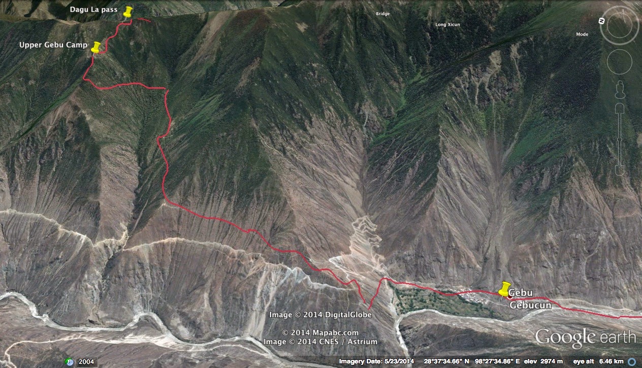
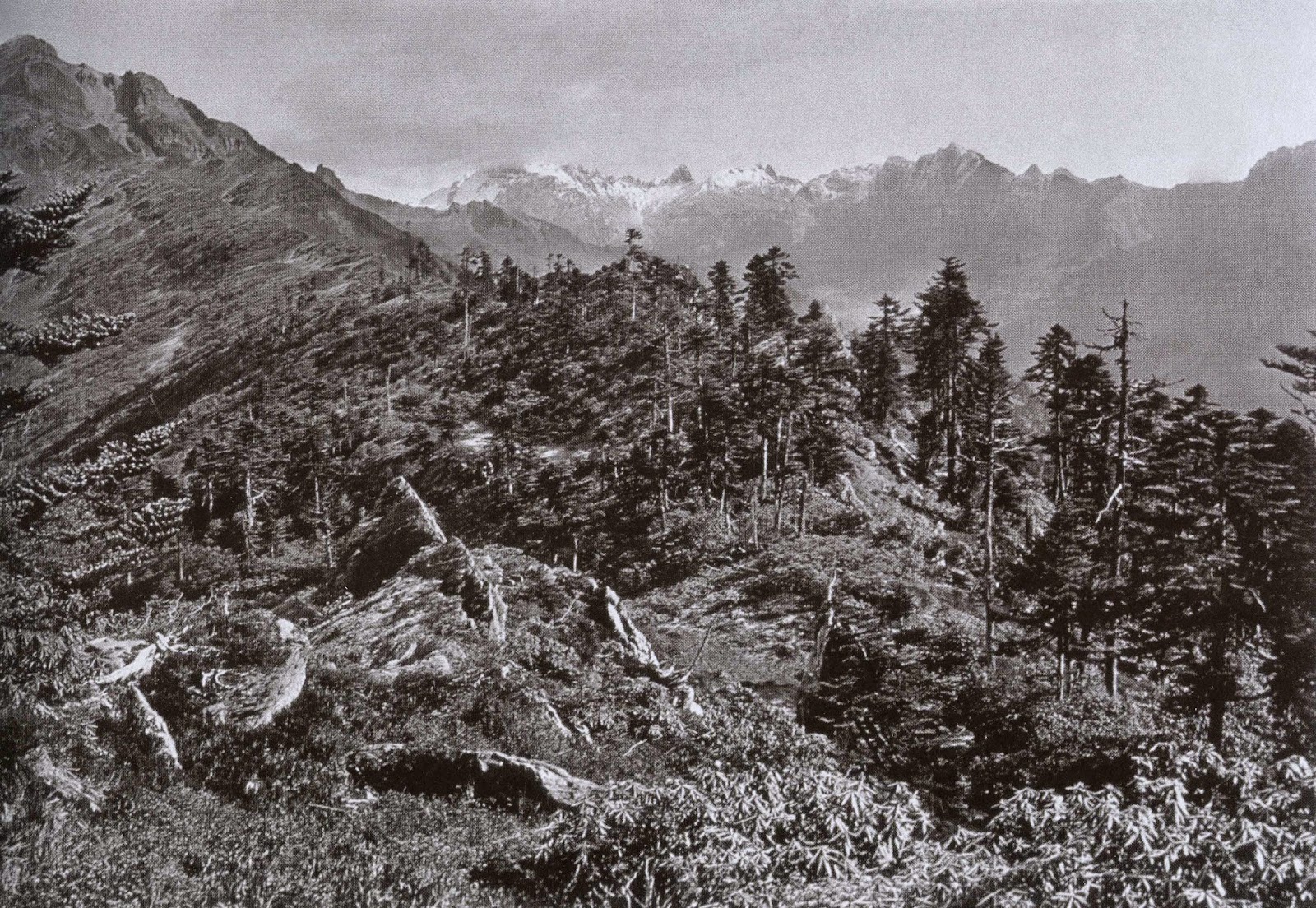
Kawa Karpo kora: view looking north from Gebu high camp

From the 1990s archives: Muti Konka (aka Maidi Ganga 麦地贡嘎), Sichuan

This remote mountain is located about two days hard travelling on horseback from Jiulong country, south of Kangding - near to the Yalong river canyon.
Thursday, November 27, 2014

Tuesday, November 25, 2014
The Wichu (Qiqu) river valley

Monday, November 24, 2014
Yufeng Si (temple) Camellia tree 1990s and now

This was taken during our ill-fated attempt to hike to Yading via Muli. Me and these kiwis got as far as Muli and halfway over to the Shouchu valley before getting bogged down and lost. And getting a logging truck back to Muli (Wachang). We visited the Yufeng Si temple near Lijiang before we set off. Keith Lyons (second right) liked the place so much he settled there and now runs his guiding agency in Lijiang.

Same tree, 20 years later. Autumn, so not in bloom.
Video of the earthquake in Kangding
Some 'vision' of the earthquake as captured by Kangding street cameras.
Friday, November 21, 2014

Monday, November 17, 2014
Pic of the day: Deqin (Atuntze)

I tried to take this photo from the same spot where Joseph Rock took his photo in 1926 of Deqin (then known as Atuntze). His photo showed a forlorn village of just a few mud houses in a sloping valley. It was only when I climbed to the top of this hill above Deqin where the monastery used to be that I realised he had taken his photo much further away, from the curve of a track at the top of the valley. By this time it was too late in the day to get there, so I did a direct descent past a chorten, back into town. This vantage point is on the hill above the town square, reached by a twisting switchback road that passes a small valley with a waterfall. There is a more direct route straight up if you can find the obscure path that leads up there. The monastery is now being rebuilt in concrete, after having being demolished during the Cultural revolution and transposed to the other side of the valley (an unlucky spot, apparently). The site of the old monastery is now occupied by a village called Gusong.
Friday, November 14, 2014

Monday, November 10, 2014
Cizhong, Yunnan 茨中

Sunday, November 09, 2014
Alexander David-Neel: the Joseph Rock connection
.JPG)

Still, it is tantalising to think what would have happened if these two explorers had come face to face back in 1924 on the pilgrim route to the Doker La. The Belgian-French spiritualist and writer who inspired Kerouac meeting up with the irascible self-promoting Austrian emigre scholar. I get the impression that Rock had little time for women, both socially and intellectually. They would have made an interesting contrast sharing a tent and perhaps a cup of coffee in the Tibetan borderlands in 1924. I came across a letter from David-Neel to Rock in the Edinburgh Botanic Gardens archives a couple of years ago - I wish I'd made a copy of it now.
Anyway, it was interesting to read the account of another traveller on the "Dokar Pass" and the route to Thibet as she calls it - and it also acts as a reminder to be sceptical about Rock's claims to be the 'first white man' to explore this area.
.JPG)
Friday, November 07, 2014
Random photo: the Sila Pass, near Cizhong (by Rolleicord)

Wednesday, November 05, 2014
How to do the Kawakarpo Outer Kora - a trekking guide
by Michael Woodhead
A guide to the Kawakarpo Kora trek (Meili Waizhuang 梅里外转), with track notes for “pilgrims” (朝圣 ‘chaosheng’)
A guide to the Kawakarpo Kora trek (Meili Waizhuang 梅里外转), with track notes for “pilgrims” (朝圣 ‘chaosheng’)

Introduction
My photos and trek diary of the Kawakarpo outer kora are here:
Part 1: (Southern, Mekong to Nujiang): http://www.josephrock.net/2013/01/the-kawa-karpo-outer-kora-crossing.html)
Part 2: (Northern, Nujiang to Mekong): http://www.josephrock.net/2014/11/kawakarpo-outer-kora-part-2-from-aben.html
The Kawakarpo Kora is one of the best treks in the world, but done by surprisingly few westerners. It is a traditional pilgrimage route for Tibetans, that involves a 150km trek around the sacred peaks of the Kawakarpo mountain range. The main peak of this range, also known as 'Kawegebo' or Meili Xueshan (beautiful snow mountain) is 6740 metres in height and is revered by Tibetan Buddhists. The trek usually takes about 8-10 days and involves crossing seven mountain passes including the main ones known as the 4080m Doker La (east to west) and the 4800m ShoLa (west to east). The track starts near Deqin, in the north west corner of Yunnan province and traverses across the Hengduan mountain range from the Mekong (Lancang Jiang) river in Yunnan to the Salween (Nu Jiang) river. Half of the circuit involves a crossing into Tibet, and this may be a reason why few westerners do the trek - it is difficult to obtain a Tibet entry permit for the trek. However, most of the trek is on un-policed mountain trails and it is possible to avoid the only security checkpoint on the road into Tibet (more details later).
The trek is not particularly difficult but it is quite strenuous and requires stamina and a reasonable level of physical fitness. The good news is that there is a well-trodden track and - unusually for China - a network of simple guesthouses and shops along the trail, so you don't need a tent or to take 10 days worth of food. However, this walk is not to be taken lightly - the weather conditions can turn treacherous, especially on the passes, and you must come prepared with warm and waterproof clothes and good boots. It is also a very remote trek - you can expect to be away from civilisation for days on end, with no mobile phone access and walking in remote valleys where the nearest basic medical facilities are two or three days walk away. There are no mountain rescue teams and no authorities available to help you out if things go wrong - you must be self sufficient and flexible. On a positive note it is a safe area and you will be trekking alongside Tibetan pilgrims who are invariably friendly and helpful.
It is possible to do the trek without a guide, but I would strongly advise against this. A local guide is essential for routefinding in some areas and also as a go-between in dealing with other Tibetans and helping arrange accomodation and transport. You can arrange guides in Yongzhi or even with the van drivers at Fei Lai Si, many of whom hail from Chalitong. Speaking at least some Chinese will obviously be helpful. Local Tibetans do not speak English, and many don't speak Mandarin to a high standard so you must be prepared to improvise use sign language. Alternatively, you can do one of the commercial guided treks around the kora such as the excellent one run by Adrian Bottomley of Whistling Arrow.
If you want to see my blogs of the two kora treks I've done click here and here. If you want to see photos from each day of the trip, try this Chinese language blog here.
If you want to see my blogs of the two kora treks I've done click here and here. If you want to see photos from each day of the trip, try this Chinese language blog here.
When to go
The best times to go are spring (May-June) and late autumn (September-November), when the weather is dry and settled. Avoid summer as this is the wet/monsoon season, while in Jan-April the high passes may be closed due to snow.
Getting to the start of the track
The start of the kora is at a village
called Yongzhi, just above the Mekong (Lancang Jiang) river, about 25km south
west of Deqin. Hire a minivan in Deqin or at the Fei Lai Si viewing point for
the mountain, where most tourists stay. Cost will be about 300 yuan. The road
goes down to the river and follows the right (east bank) through a small town
called Yunling (云岭), and crosses the river at a place
called Chalitong.
There are actually two alternate
routes to start the kora, the upper and
lower tracks. The upper track starts at Yongzhi (2480m) and skirts the upper
side of the Yongzhi gorge as it ascends the valley. The lower track starts at
the river near Chalitong and follows the tributary river up through the Yongzhi gorge.
The two tracks merge further up the valley. There are no shops at Yongzhi
except for perhaps the most basic supplies (water, instant noodles) so make
sure you do your final shopping in Deqin.
Day 1: Yongzhi 永久to Yongshitong camp永是通

From Yongzhi the track ascends a track
across fairly open hillside to the south until it reaches a corner ‘pass’ (the Duola Yakou多拉垭口) and turns into the
Yongzhi gorge. There are good views of the Mekong below. After the pass the
track levels out somewhat and enters thicker forest so the views are more limited,
except for occasional views down into the Yongzhi gorge.
The track passes some
shrines and sets of prayers flags including one place called A-se Jialang(阿色加朗) where pilgrims have left offering such as clothes and items of
clothing. The track passes a place called LongNa (隆那) continues in this way through the forest,
passing the first of many ‘rest stations’ at a place called Qu Xia (曲夏). This is a rather gloomy spot in a gully, and it best to continue
on to the camps further on. The rest stations typically comprise a wooden shack
containing a small shop selling noodles, drinks and basic commodities such as
lighters and cigs. They also have a fire with a pot of boiling water.
The
larger stations also have a ‘dorm’ which is basically just a large flat area
sheltered with large sheets of heavy duty polythene spread over logs. Pilgrims
cram into these sleeping areas and spread out their sleeping bags on old bits of
cardboard on the bare ground. On the first day the camp to aim for is
at Yongshitong (3340m) which is next to a small river, higher up in the valley.

Day 2: Cross the Duokela 多克拉垭口(4080m) to Zansutang camp 咱俗塘 (3630m)

The second day involves a strenuous hike over one of the highlights
of the trek – the Doker La pass or Duokela as it is called in Chinese. From
Yongshitong the track ascends through thick forest for several hours, following
the course of the river until it comes out into a wide valley surrounded by
high mountain ridges. The views here are superb and there are waterfalls and
may peaks to be seen.
The track continues to follow the river, passing more
shacks, until it reaches the Duokela Base Camp(多克拉垭口下). This camp an be reached by early afternoon from Yongshitong. From
the base camp’ the track turns left and ascends steeply up the western side of
the valley up towards the Doker La.
After an hour or so the track comes out into a wide basin, where the
track can be seen zig-zagging up to the Doker La. From here the forest is left
behind and it is another couple of hours walking up an increasingly steep track
to the pass.
The final stages of the
track up to the pass are over windswept scree and rock. The pass itself is
festooned with hundreds of prayer flags with only a narrow passage through
which the track crosses the narrow ridge.

It is a sacred place for Tibetans and also
marks the border of Yunnan and Tibet – once over the pass you are in Tibet (illegally
if you don’t have a permit).
The view from the pass are great in both
directions. On the western side of the pass the track descends in very steep
and quite exposed zig zags into a bowl-like basin, gradually easing off in
angle with descent. The track then veers off to the left and follows the valley
down in a twisting path that later follows the right hand side of the valley
down towards a river.
The Zansutang camp is ‘round the corner’ and located by
the side of the river. It is quite a
sizeable camp with a shop and most pilgrims stop over here after crossing the
Doker La.

Day 3: Zansutang camp咱俗塘 to Qunatang camp 曲那塘 2460m

The third day walk is mostly in forest
and involves crossing only one lesser pass, the Lu-a Sen La yakou (卢阿森拉垭口, 3840m). The track follows
the river is mostly fairly level and passes through a place called Zhangqie Lu(章切路) before ascending to the Lu-a Senla Pass. This has many bowls of tsampa and other offerings such as clothing
strewn about. After the pass there is a steep descent through forest to a
bridge and rest station/camp at a place called Qunatang. There is a second camp
some way further up the side of the hill, in a pleasant gully next to a stream
and small bridge.
Day 4: Qunatang camp 曲那塘 to Aben village (Abing,阿丙村2290m)

The first half of the day is spent
climbing up through forest to the Xinkang
La pass (辛康拉垭口, 3740m). There is
little water en route, but there are a couple of rest stations and shops
further up. The ascent is quite arduous and dull because of the lack of views –
but the views from the pass over to the Nujiang are very good. The Xinkang La
is a large pass in forest, as usual strewn with prayer flags. From the pass you
can look down and see the destination of Aben far below. The second half of the
day is spent on the long and knee-hammering descent to Aben. The track goes
through pine forest before emerging into more open farmed land lower down.
Interlude: Getting past the Tibet checkpoint from Aben to Chawalong.
Aben is a Tibetan community of
about twenty houses and is a major waypoint on the kora. It has several
guesthouses and shops, so is a good place to rest and stock up on basic
supplies. However, the next stage presents a problem for westerners without
permits as it follows the motorable road up the Nujiang, with a police
checkpoint at a place called Quzhu (曲珠)。The only way to get round this is to get
a local with a motorbike to take you past the checkpoint after dark. The road
barrier is closed so only bikes can get past.
It takes about an hour by
motorbike down to the checkpoint and a further hour or so beyond to the Tibetan
town of Chawalong (察瓦龙, which the Tibetans call Chana). Some drivers insist that you get off
the bike and walk through the checkpoint alone, as they fear being caught in
the act of helping a foreigner through
the checkpoint. There are warning signs on the road saying that foreigners are not permitted, even though the actual
border with Tibet is about 10km further south.

The dirt road is quite rough and
hazardous, often with steep drops into the river. The landscape along the river is awesome,
mostly uninhabited and quite barren with cactuses, and there is a major
landslide that has to be crossed before reaching Chawalong. The driver/guide
should be able to arrange for you to stay in a house in or near Chawalong. As
Chawalong is in Tibet, you may be reported to the police and expelled if you
try stay in an official guesthouse. If you do get caught, expect to be detained, fined and then sent to the nearest town in Yunnan, Bingzhongluo, which is a day’s drive in a 4WD along a treacherous road through the Nujiang canyon that will cost you 1500 yuan or more.
Day 5: Chawalong (1910m) to Gebu (格布村, 2340m)
This section is optional. Many trekkers
get a lift straight through to Gebu, about two –three hours further north on a
road that crosses the Tangdu La pass (堂堆拉垭口, 3352m). If you decide to walk it is
about 15km on the road from Chawalong up through a village called Longpu (龙普村) and some sparse pine forest to the
Tangdu La, passing a small monastery called Zhatong. There are short-cuts of
track between the zig-zags of the road up the steep hillside. The pass is just
a cutting through the high point of the ridge, in forest, with an ugly
electricity pylon, though with some views back over Chawalong. There is a small
shop here and a place to get boiling water.

The road descends from the pass through
more forest, down past rice fields of Tangdu village and then into a spectacular
canyon of a river called the Wichu (Chinese: Yuqu, 玉曲). There is a great view of a high mountain to the north. The
steep-sided canyon is quite arid and
devoid of vegetation compared to the more fertile land around Chawalong.
The road passes a settlements called Zhagu
(扎古组) and Reda then continues down a barren and rocky trail around
a dramatic bend in the river to a settlement called Lada (拉达) which has a small shop and more
rice terraces and then on a dusty road. The river is crossed by a bridge beyond Lada,
and the road continues to the village of Gebu.
The village of Gebu has a guesthouse and
a shop, and is the jumping off point for the next major pass – the Dagu La (达古拉垭口), but more often known just as the Gebu
La.
Day 6: Gebu to Gebu Pass Hut (3900m).
A zig zag road ascends steeply out of
Gebu up to a ‘shoulder’ hill to the north, on top of which is a wooden shack
with a shop and rest station. Some pilgrims take a motorbike taxi up to the
shack and stop there for the night rather than in Gebu. There are great views back over Gebu and down
the Wichu canyon towards the Tangdu La.
From the shack the track leaves the
road and goes up through arid worn
channels into forest, from where it levels out and follows a gentler gradient
north along the hillside through open forest towards a second rest station
reached in about an hour. This is the last shop before the pass, so stock up on
fluids here as there is little water to be had for the rest of the day.
The track leaves the hillside and its
views of the river and climbs up through forest towards the pass. The path is
good and there are occasional fine views to the west and especially of a snowy
peak that may be Kenyichunpo on the Burmese border. The track is not steep but
it is quite a hike up to the next shack and rest station, which is situated
about an hour’s hike below the Gebu Pass (also known as Dagu La, 达古拉垭口).
This is a very simple shack with
space for about twenty people to sleep outside under the plastic sheeting.
There is a basic shop and fireplace, but water is limited to a trickle from a
nearby pipe. There is a lot of rubbish here and no toilets, so beware of
sanitation and drinking water. There is a small viewing area just above the
shack with great views over the valley.
Day 7 Gebu Pass hut to Laide (来得 3090m)
From the Gebu Pass hut it takes about an
hour to hike up to the Dagu La (达古拉垭口) through forest. The pass is covered by
forest, but there are some views to be had to the west of the snowy peak. The
track then descends, steeply at first, over a trail into another loop of the upper
reaches of the Wichu river canyon. There are some nice views to the north but
soon the track turns south east and descends more gradually through the thick
forest towards the river following the contours of the hillside. There are no
rest stations or water sources on this part of the trail.

After a long descent the track stays
fairly level for an hour or so of walking then
emerges from the forest and skirts some curves around the hillside. The
river can be seen below and the ridges on the other (eastern) side of the
valley come into view. The mountain Kawakarpu (Meili Xueshan) dominates the
southern section of the valley. The track passes through fertile glades and
gullies as it descends to the river, on the other side of which a crude road
can be seen. As the track reaches the river a sharp switchback trail down a
gully needs to be negotiated after a cliff walk, until the riverside is
reached. A level track passes through a gate and comes out at a bridge to a
couple of Tibetan houses at Laide bridge or Long Xicun.
From the bridge it is a further two hour
walk up a zig zag track through scrub and low bushes to the small village of
Laide, nestled in a side valley. There are informal guesthouses at Laide,
including one at a large house with a shop that is set apart, about five
minutes higher up the valley on the way up to the Sho La pass. It may also be
possible to camp here.
Day 8: Laide to Sho La Pass hut (说拉垭口4300m)
From Laide the track ascends up through
forest up to a ridge and then on up to a set of huts in the “Meiqui Bugong” (梅求补功)valley that leads up to the highest part
of the kora – the ShoLa pass or Shuola (说拉垭口). This can be a very tedious and
strenuous section to hike, with little
variety to the endless zig zags up through the forest. There is also no water
en route and no rest stations etc until
you reach the hut just below the
plateau. The hike takes about four hours, with only occasional views
back over Laide and the Wichu valley to break the monotony.

However, once you
have reached the plateau hut you have done most of the vertical climbing for
the pass. There are two sets of huts
close together, the first is in the forest
and is where most pilgrims stay. A second more primitive hut is about fifteen
minutes hike further up, in more open terrain. From here some Tibetans ferry
pilgrims on motorbikes over the last kilometer or so up to the base of the
Shola pass.
The track turns east and skirts gently upwards over more open
terrain, towards a basin that forms the beginning of the Shola pass. There are
good views of the north side of the Kawakarpo range from here. The track
ascends through scrub after leaving the treeline, and eventually reaches the
final hut before the pass. This is located in a shallow gully, but is very
exposed to the elements and is often left locked and unattended. Don’t rely on
it being open.
From here you have a choice of staying before the pass or
crossing the pass later in the day and staying at the hut on the other side. The
latter is preferable as the sun does not rise over the mountains until after
9am, and so the scenery is not very
impressive if you make the early start that is necessary to walk from the
pre-pass hut to the end of the trail.
Day 9: ShuoLa Pass (4800m) to Meili Shi (梅里石)
From the ShoLa huts the trail enters more
windswept and barren alpine terrain, culminating in the red rocky basin devoid
of any plant life that leads up to the pass. There are some good views of
Kawakarpo on the way up – make the most of them as this is the last you will
see of the peak on the kora.

The track is obvious for most of the way
although there are several smaller tracks leading up o the final section of the
ridge. The going is straightforward in good, clear weather but could be
treacherous in fog, snow or ice – and thus good visibility is needed, as well as
weatherproof kit. The final few metres of trail to the pass is not too steep, and it
culminates in the usual sea of prayer flags. The views in both directions are
excellent, although Kawakarpo is not visible from the ShoLa. The views to the
east towards the Mekong are especially impressive. The rocky ridges on either
side of the pass are also awesome.
After enjoying the pass, which marks the
Tibet border, you can descend the track into Yunnan and head back down towards
the basin and the vegetation zone. The track is easy to follow and mostly good, and
within an hour you have left the scree slopes and entered a zone of trees and
shrubs, out of the worst of the wind. The track heads right and follows a
valley down to a clearing, called Dulongtong (杜隆塘) where there is a small hut
with a blue roof next to the marshy beginnings of a stream. There appeared to
be other [abandoned] huts nearby.
From this point it is about a four-five
hour descent to the road, along a track that stays mostly on the left side of a
mountain river that gushes through the forest. The descent is not difficult but
can seem never-ending and onerous. About half way there is a sacred waterfall
where Tibetans leave banknote offerings. There are also some clearings by the
river further down, which would make good camping spots. Water is not a problem
because of the river (if you can boil/sterilize the water).
The track crosses
and re-crosses the river many times and eventually enters a series of narrow,
steep sided gullies. At this point the lower valleys of the Mekong/Lancang river
come into view, but there is still a long way to go to reach the end of the
trail. The track winds down a series of defiles and gullies, with each one
seeming to be the last, but always leading to another. After a long ear-popping
descent, signs of reaching civilization appear, such as metal bridges and
concrete water irrigation channels. The final few kilometres of the kora are a
series of rock-strewn paths through gullies in what can be very dry terrain as
the sun beats down in the afternoon.
The end of the trail finally comes in
sight and there is nothing to mark the end of the kora but a milestone on the
quiet highway running along the Mekong. There are sometimes minivans waiting
for hire to take pilgrims beack to Deqin. If not, it may be possible to hitch,
or it is about a kilometre walk right (south) to the village of Meilishi (梅里石) which has shops and possibly a guesthouse. The cost of a minivan for
the two hour journey to Deqin is about 200 yuan.
Tuesday, November 04, 2014

Monday, November 03, 2014
The Balagong Pass - by Rolleicord and Kodak Ektachrome

This is the view of the final few metres leading up to the Balagong Pass, from the east (Sewalong Valley) side. As you can see it is a fairly gentle pass but it took a lot of huffing and puffing to get up there through the forest. Because of the trees there is no good view from the pass itself - but there are excellent views about 15 minutes further down on either side. Just over the top of the pass the Nujiang valley comes into view, very different from the Sewalongba valley and the Mekong valley before that - and you can see the ridges in the distance all the way to Burma. But that's another picture.
Sunday, November 02, 2014
Valley to the east of the She-La (Selalaka Pass)

I don't know if it has a name but this is the valley up which I walked from Cizhong to get to the She-La pass. As described in my previous article, we overnighted in a hut next to the river that can just be seen at centre right. The track then moves to the left of this picture - some of the higher trail is visible at left. If coming from Dimaluo, of course, this is the valley you will descend into. The photo was taken with my Rolleicord and Kodak Ektachrome transparency film (now sadly discontinued).
Saturday, November 01, 2014
The 120 film transparencies from the Yunnan-Tibet trek are in!
Just picked up about 12 rolls of Medium Format transparencies taken with the Rolleicord camera on my recent visit to the She-La and Kawakarpo kora in Yunnan. Here's a sample, a picture of the Sewalongba valley taken from near the Balagong pass on the way to Baihanluo. This is looking north, back towards the Shelalaka Pass that I had crossed earlier in the day (marked with red arrow).

Interlude: some great books of photos from old Yunnan

After my recent trip to the She-La and the Kawakarpo kora in Yunnan I stopped over in Kunming for a bit of R&R. As well as drinking myself stupid at Salvador's Bar (and running up a 450 yuan bar tab) I visited the wonderful Mandarin Books store down the street on Wenlin Jie. There I picked up a great book by Robert K Moseley called Revisiting Shangri La. A man after my own heart, Bob has been taking "then and now" pictures of Yunnan, often using many previously unseen photos by J.F. Rock. One of them caught my eye - his photo of the Baragong Pass (aka Balagong) that I had just crossed the week before while doing the Mekong-Nujiang traverse from Cizhong to Dimaluo. The original picture by Joseph Rock shows a more barren pass, and as Bob notes there is now more tree growth and rhododendron trees at this location compared to the 1920s. The book has many such excellent comparisons and some great explanatory texts. I only wish I knew how he'd got access to all those original photos. Bob Moseley spent a few years living in Deqin while working for Nature Conservancy China so had access to many interesting sites. This book is well worth getting if you can find it.
And in more recent times:

Another book I picked up in Kunming was "China in the Eyes of the Flying Tigers", a beautiful series of Kodachrome images taken by former WW2 USAAF members H. Allen Larsen and William Dibble. The pictures of Kunming, Chongqing and Hangzhou are absolutely stunning and give a rare glimpse into what the places would have looked like in colour during Rock's time there. I picked this up at the Kunming museum, which had a permanent exhibition dedicated to the Flying Tigers.

Here's one of the images, of the lake in the park in old Kunming:

Tuesday, October 28, 2014
The final day: over the Sho La Pass (说拉垭口) at last
The uncertainty and seat-of-your-pants planning that had plagued this trek persisted to the very end. When I woke up at the 4250 metre camp above Laide I had no idea if my guide would be continuing with me to the pass - or even if I would cross the pass that day. In truth, I didn't even know where I was. I had no maps, only some printouts of rough screengrabs from Google Earth that suggested I was high up near the final track leading up to the Sho La pass. But as with the previous day, I wasn't sure if the higher plateau was ten minutes away or two hours up the hill. All I knew was that there was still a bit of a walk up to the pass, which was the highest on this trek at 4815 metres (15,800 feet - higher than I had ever been). I also knew that there was another hut just before the pass, located in an exposed gully. I had this notion that I might walk as far as this hut (two or three hours away?) and stay there for the night, exploring the area around the pass. However, the 'manager' of this camp soon quashed that idea. He was a gruff Tibetan with a thick mane of hair, and told me he also 'controlled' the other hut, but that there was nobody there at the moment. It was locked up and not available to stay in. So it was the Sho La pass or bust.

The Tibetan pilgrims, as usual, were up before dawn and most of them left like a flock of chattering birds before it got light. The few of us remaining got up at 7am and I struggled through the motions of brushing my teeth, washing my face and finding somewhere to go to the loo.

Outside it was cold but the air was still and I got a great early view of the mass of Kawakarpo to the south, peeking up in the clear sky over the treetops. The view didn't last long though - within 20 minutes, thick fog had rolled up from the valleys. After just a few days of trekking my skin and clothes were coated with a thick layer of dirt, grease and dust. I stank of woodsmoke and sweat, and my hair was ragged like a stiff brush. I used a little of the local water trickle to make some coffee and to rehydrate the milk powder for my muesli. The water was brackish, gritty and tasted of smoke. When I asked the hut owner if he had any bottled water he shook his head and pulled out a box of Coca Cola - that was the only fluid he had except for beer. I took a can of each.
We set off up the hill early, with my guide saying he would accompany me as far as the pass - but he would not say what his plans were beyond that. I counted myself fortunate that at least I had someone to carry my pack that far. I reckoned I could lug it myself down the hill after the pass.
I was pleasantly surprised to find that we reached the crest of the ridge fairly quickly, within 15 minutes. There was another primitive log shelter and from here the track levelled out and skirted the side of the slope to the left, and into the final valley that led up to the pass. The track passed through stands of bushes and low shrubs, but there wasn't much of a view. Much of the landscape was still in dark shadows as the sun had yet to rise over the ridge.

As we skirted the contours, the valley below was still filled with cloud, and the landscape became bleaker as we rose above the vegetation line. Now the ground was almost martian - red and grey rocks and scattered boulders. After an hour we reached a small gully with a dried up creek, aside of which lay the final hut. As the owner had told us it was closed up and deserted. No place to stop.
The track took one final twist to the left and we hiked up into the final basin before the Sho La pass. This was it - the final destination.

As if on cue, the sun started to light up the landscape, bringing a feeble touch of warmth to the red rocks. From here the trail to the pass could be seen zig-zagging upwards, culminating in a distant field of prayer flags. My guide stopped and prostrated himself and clasped his hands together in prayer.

It only remained to pick our way over the boulder field and choose one of the several faint trails that led up to the pass. There was no sign of the other pilgrims and nobody else about: it felt like we had the whole mountain to ourselves. This was the culmination of the trek and my excitement rose as I stumbled up the last few metres and caught site of the passageway through the mass of prayer flags that marked the pass.

A few more steps and I arrived at the pass, feeling triumphant. Walking through the mass of prayer flags, I gasped as I saw the epic view over the other side back down into Yunnan. In theory I was no longer illegal. The Sho La (Chinese: Shuola Yakou, 说拉垭口) pass marked the border between Tibet and Yunnan, the high watershed between the Nu Jiang river and the Mekong (Lancang Jiang). On the Mekong side it was sunny and bright, while much of the Nu Jiang side of the pass remained hidden in shade.

I spent about 15 minutes on the pass, savouring the views and taking a few photos. The views over to the Mekong were awesome - though many of the ridges and valles were already being hidden by rising clouds. Many of the pictures of the Sho-La pass I had seen on the internet showed it to be a bleak and inhospitable place, often covered with snow and ice. I was lucky - I had perfect weather for this crossing, the air was clear and still, if a little chill.

I felt like the conquering hero, having reached this new height of 4800 metres. However, just as I was priding myself on my ruggedness, I heard cooing noises and looked through the arch of prayer flags to see a group of Tibetan women arriving, carrying babies and infants with them. One woman even had a milk bottle and was preparing for a bottle feed. All of a sudden I didn't feel so special. Despite the cold wind the group of women were dressed in light clothing, as if out for a stroll on a spring day, while I was wrapped up in my windproof jacket and with my scarf around my neck. The women parked themselves on the sunny side of the pass and started to feed their kids. I had no idea where they had come from - there had been no sign of them at the hut and I couldn't fathom where they had spent the previous evening - we were at least a day's hike from the nearest village in the valleys far below.

Meanwhile, my guide was looking restless. He gestured for me to take my backpack, and I paid him off for the last three days of portering and acting as a xiangdao (guide). He'd said he was going to return back down the mountain towards his home near Chawalong, but then a few moments later he asked if I wanted to pay him another day's fee and have him carry my pack down to the Mekong. I declined, and he said he would be walking down that way anyway.

And so I set off alone down from the pass, leaving Tibet behind, back into to Yunnan. It would be all downhill from here. But before I departed I left my can of beer among the prayer flags at he pass, along with all the offerings left by the Tibetans, as an offering to the mountain gods.
The path descended through the stone and scree fields towards the green and brown vegetation of the wide basin below, surrounded by ridges of orange and grey crags. All very beautiful.

As I pounded down the trail with my backpack weighing heavily on my shoulders for the first time, I pondered a strange and macabre death that had occurred at this spot. About three years previously an eccentric Australian woman called Margo who lived at the Tiger Leaping Gorge near Lijiang had died near the Sho La pass after attempting a solo crossing. As I related in a previous blog post, her body had eventually been found near the pass and it was presumed that she had lost her way and died of exposure after being stranded overnight while unequipped for the extreme weather of the high mountains. Margo had been encountered earlier on the trail by another group of western trekkers who had been doing the kora at the same time. She had acted in a bizarre and aggressive manner towards them and threatened to have them arrested. While she had a guide, Margo had walked ahead and alone for much of the kora, and had gone missing while crossing the Sho La pass. The full story is here: (Wayback archive).
What puzzled me was how she had managed to get lost. Having just completed the crossing of the pass myself, I couldn't understand how Margo had gone off the trail because it was so obvious and well trodden, except for perhaps the final few hundred metres. I could only guess that she had deliberately gone off the trail or had become disoriented in poor light (and yet the other trekkers say the weather was not bad during the time of their crossing). And as the Tibetan mothers and babies had shown, even a lightly equipped trekker could cross the pass if they were lucky with the weather. It would remain a mystery.

I was luckier than I realised. During the same week of my trek over the 4800 metre Sho La pass, disaster struck a large number of western trekkers in another part of the Himalayas, crossing a similar pass on the Annapurna circuit in Nepal. A sudden snowstorm trapped scores of people crossing the Throng La, and at least 40 were killed by the cold conditions or avalanches.

I had no such problems on my descent. The weather was perfect and the track was good. I regained the vegetation zone and walked amid a pristine landscape of pine and spruce trees, down to a clearing where a small hut with a blue roof had a wisp of smoke coming from within. I didn't go in, but continued down into the forest. The trail followed a stream that grew into a strong torrent as it got further down.

At one point it formed a waterfall, and the Tibetans had turned the pool beneath into a kind of wishing well, with banknotes plastered over the rocks. It was an unlucky site for me, as I left my umbrella behind here and only realised much further down the trail, by which time I had no intention of walking back down to retrieve it.

The walk down through the forest took many hours, including a brief stop for lunch by the river. I was alone for much of it, having left the Tibetan mothers behind a short distance below the pass.
By mid afternoon, however, I caught up with a group of Han Chinese trekkers who had been doing the kora for the last ten days. They were all very well equipped, and strode purposefully down the track wielding their trekking poles and shooting me quizzical looks as I passed them. I'd been told by the last hut manager that the descent from the Sho-La pass to the road would take four hours. That must have been the Tibetan high speed walking pace, because after leaving the pass at 9am I was still wearily plodding down the gorge at 1pm with no end in sight. I had emerged from the forest and entered a series of dry defiles and gullies, down which the track plunged towards the distant valley bottom.

By now the end was in sight, but still frustratingly far away. I could see the opposite side of the Mekong valley and even some houses and farms there, but each gully led only to another, and I seemed to be getting no nearer to the final strait. The sun was now high in the sky and my Coca Cola energy drink long exhausted. I had no other water so filled my bottles from the river and popped purifying tablets in them. This meant I faced a a thirsty 30 minute wait for the sterilising tablets to dissolve and take effect.

The path crossed and re-crossed the river many times, and by mid afternoon I had also caught up with the Tibetan monks and nun pilgrims who had shared the hut with me the previous night. My ears popped many times with the gradual loss of altitude before I eventually started to see signs of encroaching civilisation: first a concrete bridge instead of one made of logs, then a water irrigation channel - and then piles of rubbish - and flies.
It wasn't until late afternoon that I turned round a large rockface and saw the end in sight - the road about half a kilometre away. Just a couple more descending loop sections of track and I arrived at a stretch of road by the brown Mekong river. There was nothing there at all to mark that this was the end of a pilgrimage, the terminus for an epic, 10-day journey that had begun in Deqin more than 240km and five high mountain passes away around the circuit. No signs, no markers, no shrines or visitor's books to commemorate the completion of this long walk. There were no signs of life or habitation at the end of the the kora trail - just the brown river and a generic concrete road sign advising to guard against forest fires.

I was lucky in that a couple of minivans had been waiting for the Chinese trekkers, to take them back to Deqin. I was able to negotiate a ride, and thus avoid tan additional walk along the road to the village of Meili Shi about a mile away. There was little traffic on the road and I didn't think there would be much chance of a lift.
It took about two hours driving to get back to Fei Lai Si, along some spectacular sections of road that twisted up and down the canyon walls alongside the Mekong. But I was too exhausted to appreciate the scenery. I had had ten days of amazing landscapes and that was enough for me. All I wanted then was a cold beer and a lot of not walking. And that's exactly what I made sure I had when I got back to the hostel. It was as if I was in a different universe to the people around me - I was walking on air, having completed the kora.
The next morning I got up at dawn and joined the hordes to watch the sunrise over the mountain ranges. As they oohed and aahed over the first streaks of sun to hit the peas, I just took in the view and tried to comprehend that I had walked right around those mountains over the last two weeks. And felt quite chuffed with myself.

The Tibetan pilgrims, as usual, were up before dawn and most of them left like a flock of chattering birds before it got light. The few of us remaining got up at 7am and I struggled through the motions of brushing my teeth, washing my face and finding somewhere to go to the loo.
Outside it was cold but the air was still and I got a great early view of the mass of Kawakarpo to the south, peeking up in the clear sky over the treetops. The view didn't last long though - within 20 minutes, thick fog had rolled up from the valleys. After just a few days of trekking my skin and clothes were coated with a thick layer of dirt, grease and dust. I stank of woodsmoke and sweat, and my hair was ragged like a stiff brush. I used a little of the local water trickle to make some coffee and to rehydrate the milk powder for my muesli. The water was brackish, gritty and tasted of smoke. When I asked the hut owner if he had any bottled water he shook his head and pulled out a box of Coca Cola - that was the only fluid he had except for beer. I took a can of each.
We set off up the hill early, with my guide saying he would accompany me as far as the pass - but he would not say what his plans were beyond that. I counted myself fortunate that at least I had someone to carry my pack that far. I reckoned I could lug it myself down the hill after the pass.
I was pleasantly surprised to find that we reached the crest of the ridge fairly quickly, within 15 minutes. There was another primitive log shelter and from here the track levelled out and skirted the side of the slope to the left, and into the final valley that led up to the pass. The track passed through stands of bushes and low shrubs, but there wasn't much of a view. Much of the landscape was still in dark shadows as the sun had yet to rise over the ridge.
As we skirted the contours, the valley below was still filled with cloud, and the landscape became bleaker as we rose above the vegetation line. Now the ground was almost martian - red and grey rocks and scattered boulders. After an hour we reached a small gully with a dried up creek, aside of which lay the final hut. As the owner had told us it was closed up and deserted. No place to stop.
The track took one final twist to the left and we hiked up into the final basin before the Sho La pass. This was it - the final destination.
As if on cue, the sun started to light up the landscape, bringing a feeble touch of warmth to the red rocks. From here the trail to the pass could be seen zig-zagging upwards, culminating in a distant field of prayer flags. My guide stopped and prostrated himself and clasped his hands together in prayer.
It only remained to pick our way over the boulder field and choose one of the several faint trails that led up to the pass. There was no sign of the other pilgrims and nobody else about: it felt like we had the whole mountain to ourselves. This was the culmination of the trek and my excitement rose as I stumbled up the last few metres and caught site of the passageway through the mass of prayer flags that marked the pass.
A few more steps and I arrived at the pass, feeling triumphant. Walking through the mass of prayer flags, I gasped as I saw the epic view over the other side back down into Yunnan. In theory I was no longer illegal. The Sho La (Chinese: Shuola Yakou, 说拉垭口) pass marked the border between Tibet and Yunnan, the high watershed between the Nu Jiang river and the Mekong (Lancang Jiang). On the Mekong side it was sunny and bright, while much of the Nu Jiang side of the pass remained hidden in shade.
I spent about 15 minutes on the pass, savouring the views and taking a few photos. The views over to the Mekong were awesome - though many of the ridges and valles were already being hidden by rising clouds. Many of the pictures of the Sho-La pass I had seen on the internet showed it to be a bleak and inhospitable place, often covered with snow and ice. I was lucky - I had perfect weather for this crossing, the air was clear and still, if a little chill.
I felt like the conquering hero, having reached this new height of 4800 metres. However, just as I was priding myself on my ruggedness, I heard cooing noises and looked through the arch of prayer flags to see a group of Tibetan women arriving, carrying babies and infants with them. One woman even had a milk bottle and was preparing for a bottle feed. All of a sudden I didn't feel so special. Despite the cold wind the group of women were dressed in light clothing, as if out for a stroll on a spring day, while I was wrapped up in my windproof jacket and with my scarf around my neck. The women parked themselves on the sunny side of the pass and started to feed their kids. I had no idea where they had come from - there had been no sign of them at the hut and I couldn't fathom where they had spent the previous evening - we were at least a day's hike from the nearest village in the valleys far below.
Meanwhile, my guide was looking restless. He gestured for me to take my backpack, and I paid him off for the last three days of portering and acting as a xiangdao (guide). He'd said he was going to return back down the mountain towards his home near Chawalong, but then a few moments later he asked if I wanted to pay him another day's fee and have him carry my pack down to the Mekong. I declined, and he said he would be walking down that way anyway.
And so I set off alone down from the pass, leaving Tibet behind, back into to Yunnan. It would be all downhill from here. But before I departed I left my can of beer among the prayer flags at he pass, along with all the offerings left by the Tibetans, as an offering to the mountain gods.
The path descended through the stone and scree fields towards the green and brown vegetation of the wide basin below, surrounded by ridges of orange and grey crags. All very beautiful.
As I pounded down the trail with my backpack weighing heavily on my shoulders for the first time, I pondered a strange and macabre death that had occurred at this spot. About three years previously an eccentric Australian woman called Margo who lived at the Tiger Leaping Gorge near Lijiang had died near the Sho La pass after attempting a solo crossing. As I related in a previous blog post, her body had eventually been found near the pass and it was presumed that she had lost her way and died of exposure after being stranded overnight while unequipped for the extreme weather of the high mountains. Margo had been encountered earlier on the trail by another group of western trekkers who had been doing the kora at the same time. She had acted in a bizarre and aggressive manner towards them and threatened to have them arrested. While she had a guide, Margo had walked ahead and alone for much of the kora, and had gone missing while crossing the Sho La pass. The full story is here: (Wayback archive).
What puzzled me was how she had managed to get lost. Having just completed the crossing of the pass myself, I couldn't understand how Margo had gone off the trail because it was so obvious and well trodden, except for perhaps the final few hundred metres. I could only guess that she had deliberately gone off the trail or had become disoriented in poor light (and yet the other trekkers say the weather was not bad during the time of their crossing). And as the Tibetan mothers and babies had shown, even a lightly equipped trekker could cross the pass if they were lucky with the weather. It would remain a mystery.
I was luckier than I realised. During the same week of my trek over the 4800 metre Sho La pass, disaster struck a large number of western trekkers in another part of the Himalayas, crossing a similar pass on the Annapurna circuit in Nepal. A sudden snowstorm trapped scores of people crossing the Throng La, and at least 40 were killed by the cold conditions or avalanches.
I had no such problems on my descent. The weather was perfect and the track was good. I regained the vegetation zone and walked amid a pristine landscape of pine and spruce trees, down to a clearing where a small hut with a blue roof had a wisp of smoke coming from within. I didn't go in, but continued down into the forest. The trail followed a stream that grew into a strong torrent as it got further down.
At one point it formed a waterfall, and the Tibetans had turned the pool beneath into a kind of wishing well, with banknotes plastered over the rocks. It was an unlucky site for me, as I left my umbrella behind here and only realised much further down the trail, by which time I had no intention of walking back down to retrieve it.
The walk down through the forest took many hours, including a brief stop for lunch by the river. I was alone for much of it, having left the Tibetan mothers behind a short distance below the pass.
By mid afternoon, however, I caught up with a group of Han Chinese trekkers who had been doing the kora for the last ten days. They were all very well equipped, and strode purposefully down the track wielding their trekking poles and shooting me quizzical looks as I passed them. I'd been told by the last hut manager that the descent from the Sho-La pass to the road would take four hours. That must have been the Tibetan high speed walking pace, because after leaving the pass at 9am I was still wearily plodding down the gorge at 1pm with no end in sight. I had emerged from the forest and entered a series of dry defiles and gullies, down which the track plunged towards the distant valley bottom.
By now the end was in sight, but still frustratingly far away. I could see the opposite side of the Mekong valley and even some houses and farms there, but each gully led only to another, and I seemed to be getting no nearer to the final strait. The sun was now high in the sky and my Coca Cola energy drink long exhausted. I had no other water so filled my bottles from the river and popped purifying tablets in them. This meant I faced a a thirsty 30 minute wait for the sterilising tablets to dissolve and take effect.
The path crossed and re-crossed the river many times, and by mid afternoon I had also caught up with the Tibetan monks and nun pilgrims who had shared the hut with me the previous night. My ears popped many times with the gradual loss of altitude before I eventually started to see signs of encroaching civilisation: first a concrete bridge instead of one made of logs, then a water irrigation channel - and then piles of rubbish - and flies.
It wasn't until late afternoon that I turned round a large rockface and saw the end in sight - the road about half a kilometre away. Just a couple more descending loop sections of track and I arrived at a stretch of road by the brown Mekong river. There was nothing there at all to mark that this was the end of a pilgrimage, the terminus for an epic, 10-day journey that had begun in Deqin more than 240km and five high mountain passes away around the circuit. No signs, no markers, no shrines or visitor's books to commemorate the completion of this long walk. There were no signs of life or habitation at the end of the the kora trail - just the brown river and a generic concrete road sign advising to guard against forest fires.
I was lucky in that a couple of minivans had been waiting for the Chinese trekkers, to take them back to Deqin. I was able to negotiate a ride, and thus avoid tan additional walk along the road to the village of Meili Shi about a mile away. There was little traffic on the road and I didn't think there would be much chance of a lift.
It took about two hours driving to get back to Fei Lai Si, along some spectacular sections of road that twisted up and down the canyon walls alongside the Mekong. But I was too exhausted to appreciate the scenery. I had had ten days of amazing landscapes and that was enough for me. All I wanted then was a cold beer and a lot of not walking. And that's exactly what I made sure I had when I got back to the hostel. It was as if I was in a different universe to the people around me - I was walking on air, having completed the kora.
The next morning I got up at dawn and joined the hordes to watch the sunrise over the mountain ranges. As they oohed and aahed over the first streaks of sun to hit the peas, I just took in the view and tried to comprehend that I had walked right around those mountains over the last two weeks. And felt quite chuffed with myself.
Subscribe to:
Posts (Atom)


