
In the spring of 1928, Joseph Rock made a visit to the three sacred mountains (Shenrezig, Jambeyang and Chanadorje) of the Konka Risumgongba range from Muli.
These three peaks of around 6000 m in height, are also known as the Konkaling peaks, and are now part of the Yading National Park. Rock had seen the peaks from a vantage point in Muli in 1923, and had persuaded his friend the Muli king to help him travel to the mountain range using his influence over the hostile local bandits. I have explained much of the background to these 'Holy Mountains of the Outlaws' as Rock described them, in an earlier article (here and here).
Suffice to say that the Konkaling mountains were a no-go zone for non-locals because they were the domain of a band of vicious Tibetan robbers ('the scum of the outlaws' as Rock put it) led by a bandit called Drashetsongpen. Anyone who trespassed among these peaks would be robbed and murdered by his gang of robbers, who also made regular excursions to rob and pillage nearby areas. The Muli king, however, had come to an arrangement with them, paying them off and allowing them free passage across his lands in return for not molesting his subjects.
Rock was supplied with a 'safe conduct' pass and a guide by the Muli king, and set off to visit the Konkaling peaks in March 1928. 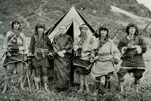
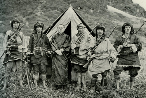
His party included 36 mules and horses, 21 Nashi assiatants, and the head lama of Muli monastery to act as a guide. Rock describes the trip in an article in the July 1931 issue of the National Geographic, in which he claims to be 'the first white man to visit the Konkaling peaks'. He says other explorers and plant hunters such as Kingdon Ward had been in the area but had never got close enough to see the peaks in good weather.
Rock approached from the eastern (Muli) side, dipping down into the stifling heat of the cavernous Shouchu river valley and then climbing out on the western side up to the village of Garu (now known as Galuo), whose tough Apache-like Tibetan inhabitants he compared favourably to the snivelling and servile subjects of the Muli king. Even these 'proud and virile' men were reluctant to escort Rock around the peaks because of the bandit threat, until Rock mocked them by suggesting he take some Garu women instead.
From Garu, Rock ascended through virgin spruce and fir forest and at higher altitudes rhododendron forest then crossed over a high pass to reach the mountains, and to make a circuit of the three peaks in the usual Tibetan Buddhist clockwise fashion. His first camp was at 15,300 feet below the scree slopes and glaciers of Chanadorje ('huge moraines resembling a vast ampitheatre'), where he says he got a great view when the clouds finally parted - 'revealing The Holder of the Thunderbolt - a truncated pyramid flanked by broad butresses like the wings of a stupendous bat'. 
This place the locals called Konka Djra-nse, or Sea Dragon's Snout. This is where we joined up with Rocks circuit, although we had come from the western side. We also got great views of the whole face of Chanadorje at this spot, and it is odd that Rock does not include any photos of this impressive view of the mountain in his article. He only includes a picture of the glacier moraines at the foot of Chanadorje, and by the look of things there is much cloud about.

From the natural campground below Chanadorje called Shingara, Rock ascended a pass and followed a valley called the Saiyo Katso, which culminated in two smaller peaks known as Dzambala. We also followed this valley, which gave great views of the side of Chanadorje, and also gave glimpses of the sliver-like side profile of Jambeyang further to the southwest.
This valley also had a small hanging valley within it, with a beautiful small lake. At this point Rock's party were commanded to try collect some local wildlife (he says he shot some snow pigeons), but they objected to the taking of life. Rock found this amusing, as the locals seemed to have no qualms about taking human lives. They also came across a few Konkaling Tibetans skulking among the trees. They had been scared by his rifle shots, assuming that humans were being shot ('since no one hereabouts wastes shot and powder on useless pigeons as we had done'). The head of the valley was blocked by an imposing black vertical wall of rock below two minor peaks. I presume this is the Yaka Pass that Rock refers to. We just called it The Wall, and it looked like a very steep ascent to a knife edge ridge.
For someone who regularly used plenty of florid prose, Rock is quite restrained in his description of the rigours of the journey around the peaks, saying only that 'our journey proved very arduous'. He describes the crossing of the Yaka Pass under a torrential downpour, with no trail to follow, and the mules and humans unable to find a good footing on the slabs of schists covered in rainwater and slippery grey mud. We had exactly the same experience, summed up by this paragraph: 'Climbing at such altitudes is difficult enough in good weather, but in a terrific hail and rain storm, with a howling gale driving the icy pellets into one's face and making one gasp for breath in this rareified atmosphere, it is doubly disagreeable.'
After crossing the Yaka Pass, Rock says he camped at the foot of hanging glaciers of moraines on the southern slopes of Mt Jambeyang. We also camped here, although it was far from an ideal camping spot. Rock says his entourage sought shelter in a cavelike space under an overhanging cliff, where pilgrims had erected chortens. 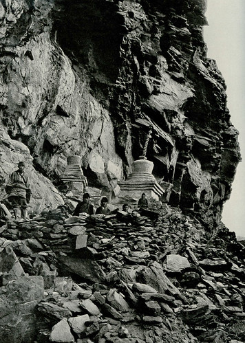
We also saw this sacred site, which was pretty much unchanged from the photograph published by Rock. There was still a makeshift wall and a couple of chortens in disrepair. And like Rock, we also spent the night listening to the thundering noise of falling blocks of ice, tumbling down from the heights of Jambeyang's glaciers.
It was near here that Rock says he encountered the dreaded bandit chief himself, Drashetsonpen, who was also making a circuit of the peaks (perhaps in expiation of his heinous crimes). His gang had sullen faces, hinting at looting and murder.
Rock sat down in the pouring rain with this bandit leader and his thirty followers, and shared some rancid yak butter and and cheese. They made little conversation except for a reassurance that Rock would not be molested.
The next section, a difficult walk along scree and snow under steep cliffs, is given little mention by Rock, except to say that his party shot a wapiti, but they were unable to bag it because the body rolled down the steep slope into the Lawatong valley far below.
The trail then makes a sudden turn northwards around the cliff shoulder, and Rock describes this new valley as Yetchesura. We found it quite easy going after the steep scree, but Rock complains that that 'the enormous slabs as smooth as a billiard table, covered with large patches of ice and snow made travelling most disagreeable'.
HIs next camp, like ours, was by one of the larger lakes in the area, a long thin lake he calls Russo Tso ('where dwell the worst of all the Konkaling outlaws').
Before we reached this we had to cross two further but relatively easy passes. After the first we came down to a fertile flat area of grass, in the middle of which was a large slab of rock as big as a house, which has become know as 'Rock's rock'. 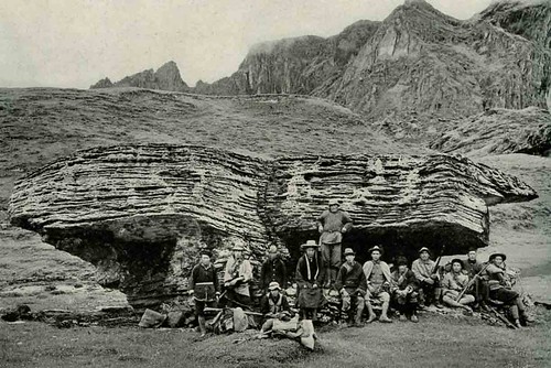
He includes a picture of his entourage sitting around this huge slab of schist, which he says must have fallen from the lower slopes of Mt Jambeyang.
While camping next to the lake, Rock says his guides were nervous, pointing up at the high slopes above them where Tibetans (presumably bandits) could be seen in the rocky ramparts, watching them.
From this lake, Rocks party climbed up to another pass with several exits (we called it the three-way pass), which divides Jambeyang from Shenrezig. This pass connects with the Konka Den valley, which is now part of the main tourist trail of Yading, giving views of all three peaks. Rock descended with his party, and his visit to and stay at the Chonggu Monastery are described in my earlier post (here).
Sunday, May 30, 2010
The Yading outer kora: some background
Saturday, May 29, 2010

Friday, May 28, 2010
Yading outer kora - we did it!

Yading outer kora - at the corner pass with Wangdu and Dorje, our guides, originally uploaded by jiulong.
Just back from the trip to Yading, where we completed the outer kora, or circuit. It was a lot tougher than I expected, especially the walking at high altitude (4000+ metres). We followed the route suggested by Lloyd Raleigh at his travel blog, but we found the going very hard in the wintery and icy conditions of mid May. We learned that the best time to do the kora would be October, as most of the potential local guides are away in May looking for the lucrative caterpillar fungus (congcao). Anyway, we managed to complete the trip and saw many of the sights described by Joseph Rock, such as the cave stupa, Rocks rock and the scree slopes at the back of Chanadorje.
I will post more pix and a more detailed route description starting from next week.
Wednesday, May 05, 2010
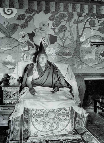
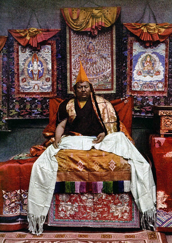
Muli king in B&W - by Joseph Rock
So this may the last post for a while - on Friday I will travelling to Chengdu, then on to 'Konkaling' (Yading) by bus, via Kangding, Litang and Daocheng. Hope to be at Yading by Wed 12th May, from where we (me and Peter from Geelong) hope to do a large circuit [kora] of Chandorje, Jambeyang and Shenrezig. This will be repeating Joseph Rock's visit of 1925, but doing it backwards -starting from the Chonggu Monastery, which was the furthest point he reached on his trip from Muli in the east.
We're expecting the trip to take five to six days of actual walking, and that means a lot of food has to be carried as we will be up at 4000 metres with no places of residence, let alone villages en route.
I'll be taking my Rolleicord medium format camera, and I hope to capture some nice images of the peaks, weather permitting. I will also be bringing my trusty Leica M2 for 35mm prints - and a little Nikon 35Ti point and shoot camera for slides. So watch this space - I will try post some updates along the way - but the great internet firewall may not allow me to do much, seeing as it blocks blogspot.
Sunday, May 02, 2010
Konkaling - Chandorje and Jambeyang

Well, only four days to go ... 'm a bit worried by the amount of gear I have in my pack - and still there are items to add. Hope we can find a horse or two to carry them.
Subscribe to:
Posts (Atom)


