Sunday, June 06, 2010

The Yading Big Kora, Day 1: Chonggu Si and the Garu Pass

It was a relief to get away from the Yading guesthouse after almost four days there, especially as the pipes had frozen and cut off the water supply to the toilets, which now stank to high heaven. We went down the hill at 8am and found the usual crowd of Tibetan horse handlers sitting around the gatehouse area. We went into manager Dorje's office and asked if he was still able to help us out with guides.
"No problem, no problem, just wait outside," he said, waving us away.

Ten minutes later he came out and said he had arranged two guides for us, at a cost of 200 kuai per day each, to take us over to Garu and on to Lugu Lake, if we wished.
"What about horses?" I asked.
"Ha! Horses can't make it! The track is too steep," he snorted. "You can only take guides - they will carry your bags for you." And the two guides he had selected were already familiar to us.
One of them, an older guy wearing a cowboy hat, had been clowning around with us the day before as I took his picture. He had asked me to send him a camera, as he didn't have one. His name was Wangdu. The other guide was the pushy and sullen guy who had been pestering us to hire him two days earlier. It didn't look like we had any choice but to hire him. His name was Dorje.

Before we set off, I sat down with both of them and thrashed out the deal. I didn't want any unpleasant extra charges or changes of plan later in the trek.
"OK, you will take us over the pass to Garu, and we will pay you 200 yuan a day for the two day trip and also two days pay for you to make the return trip. Understood?"
The sullen one agreed, but the older guy spoke up.
"Actually, it will only take us one day to return, so you only need to pay us for three days," he said, in an amazing and reassuring display of honesty.

And so that was agreed. They went off 'to get some supplies' for the trip and we waited in an almost festive atmosphere as the other Tibetans sitting around chatted about us and our trip.
Presently, Wangdu and Dorje returned with a small sack about the size of a shopping bag. That was the sum total of their supplies.
"Won't you need sleeping bags and food?" I asked.
"No need. There will be places to stay on the way. There will be people living up there," said Wangdu, pointing with his chin and lips in the Tibetan way up at the hills.
And without further ado they shouldered our packs and we set off, up the tourist track on the first stage of our trek. There were a few farewells to the assembled crowd, and then we were on our way.
After only ten minutes of walking, however, there was a lot of commotion and Wangdu turned around and put down his bag, to walk back down the hill. "Just a moment, won't be long ..." he said, as he disappeared into the distance.
He returned about ten minutes later accompanied by a young Tibetan woman with striking features, who I had noticed yesterday. It was his daughter, and she had insisted on relieving her father's load and carrying one of the bags at least as far as the monastery.

Yading by Peter Jost
Pic: Peter Jost

Once again, we were on our way, but we didn't feel very adventurous. Here we were walking up a signposted tourist trail, which we shared with Chinese day trippers who sauntered past on horseback, bidding us good day with a "How Are You?" or "Ni Hao!" greetings. My bag was being carried by a young woman and I was already sweating and struggling for breath. Not an auspicious start.

On reaching the 'bullet train' terminus Wangdu took the backpack from his daughter and said a cursory farewell. We set off once more, this time along the concrete track and I expected that we would hike the mile or so up to the gully before heading up the mountain, so it was a surprise when we almost immediately left the concrete road and followed a small footpath that meandered up into the thick forest that surrounded the trail. It was only a few hundred metres on the left from the Chonggu Si terminal, and if you are looking for it, then be advised that it forks off well before a set of picnic tables.
The track lead up through the forest, which was a mixture of larch and fir lower down, and rhododendron (with pink flowers) higher up.

Within minutes I was floundering. Every step upwards left me gasping for breath. It was as if I had just run a 100 yard sprint and was trying to get my breath back after reaching the finish line, bent over, hands on hips to try get more air into my lungs. I tried all my old high altitude trekking techniques. Counting breaths, 1-2-3-4, counting steps, stopping every ten paces, and setting myself little goals such as reaching a rock a few yards ahead ... none of it seemed to offer any relief from the unrelenting 'instant exhaustion' that befell me as soon as I put one foot in front of the other. The constant hyperventilating and the rapid beating of my heart left me worried for the strain it was all putting on my body, not to mention the nausea and faint headedness I was feeling. After an hour I was considering packing it all in. I felt like death and I was falling further behind the others as I took more and more rest stops to regain some kind of control of my breath.

Somehow, I managed to carry on, taking baby steps and bending over like an old man, crawling at snail's pace up the trail until we reached the end of the tree line and emerged from the forest into open hillside. Here the track levelled out and we could see how our little path had been a short cut that connected up with the large gully. We were on the right track.
Yading Kora Day 1
As the trail contoured around the side of the hill into the massive gully, we gained sweeping views of the Luorong valley below us, and in particular the unsightly white line of the 'bullet train' track. As we continued up the valley - we reached a basin beneath some prominent red rock turrets. On the flat grassy area were a couple of stone hut shelters. This was presumably the camping site that Joseph Rock referred to as Bayu in his account of his 1928 trip, situated in the Shindze Valley - the gully we were travelling up.

Whereas for us this was the first leg of the trip, for Rock, this was part of the final leg of his journey around the mountains, after he had spent three "most disagreeable nights" at the Chonggu Si monastery, plagued as he was by smoke, filth and ammonia-like fumes from the adjacent tables.
This is what he wrote:

"We left on the final lap for a pass up the Shindze Valley. There we camped at 15,800 feet, where we could view both Jambeyang and Shenrezig to the best advantage should weather conditions permit. We spent two nights at this high camp, called Bayu. The second morning, with a temperature of 40 degrees Fahrenheit on June 26, my lama [guide] awakened me at 4.30am, calling into my tent: 'Behold the glory of Jambeyang and Shenrezig - your luck indeed was great!' I rose and stepped into the cold grey morn. In a cloudless sky before me rose the peerless pyramid of Jambeyang, the finest mountain my eyes ever beheld. The sky was greenish black. The snowy pyramid was grey, but the apexes of both it and Shenrezig suddenly turned a golden yellow as the sun's rays kissed them."

Our luck was not so great and weather conditions did not permit such a rapturous vision. Instead, opposite us across the valley we could see the huge grey limestone razorback ridge, which I recognised from Joseph Rock's photograph of the site.
Joseph Rock view of Konkaling, 1928
In his picture, taken on a clear day, both Jambeyang and Shenrezig were visible from this point, but we could see neither of them, as their summits were obscured in the low cloud.
Yading Kora Day 1

Nevertheless, it was a nice place to take a break, and we ducked into one of the stone shelters to have lunch. Inside it was cold and dark, but at least we got some shelter from the wind. And at last I was lightening my load by consuming some of the supplies I had brought all the way from Australia. I had the first of my tuna and past ready-to-eat meals from a tin, and it didn't taste too bad, if a little oily.
Yading Kora Day 1
Then it was onwards and upwards, and the going didn't seem as bad as it had in the morning. The landscape was bleak - brownish moorland and rocky outcrops, as we ascended towards a plateau surrounded by dark rocky ridges. I had been worried about this first pass because, at over 16,000 feet, it was the highest we would have to tackle. So far, however, it didn't seem to be too hard. We ascended from one plateau to another, and the weather deteriorated as we got higher.

Yading by Peter Jost
Pic: Peter Jost

The wind blew very hard, but fortunately it was blowing from behind us. We were also bombarded with small particles of snow, almost like polystyrene balls. As we ascended a further false ridge we heard faint whoops and cries, and came across two Tibetans out gathering for congcao. They hailed us over and we sat down together for a longer rest as the fungus gatherers conferred with our two guides over a cigarette.
Yading Kora Day 1
The pass now appeared to be quite close, and we had reached a final plateau surrounded by sinister black ridges of rock. The track was marked by a series of small cairns and as we continued on up we saw what looked like the pass at the head of a shallow incline. We had made it to our first objective!
Yading Day 1 pass
Yading Day 1
Yading Kora Day 1
When we reached it, the pass was marked by the usual cairns and strings of prayer flags, many of which were in a very ragged condition because of being battered by the high winds and rain at this altitude. The pass was relatively level, and nestled beneath a large outcrop of flat, slate-like schist.
We didn't hang around for long because the bitter cold wind was blowing hard, urging us on, to start the descent in the direction of Garu.
Yading Kora Day 1
Over the ridge we were confronted by a grim and empty landscape of more jagged rocky ridges, black peaks jutting into the mist, and grey rock buttresses running into the distance. The track threaded down through the open tussock grass and made a relatively gentle descent. So much easier going down!
We plodded on down, with a massive high grey solid rock ridge emerging on our left hand side. On top of the ridge a few boulders perched precariously - one in particular looked like it had been placed there by a giant and would need only a slight push to set it rolling down the precipitous slope.
Yading Kora Day 1
Yading Kora Day 1
We were in a good mood on the way down and Peter and I noted that there had been none of the snow on the passes or steep slopes that we had been warned about so much by the naysayers back in Yading. If the highest pass was free of snow, we reasoned, the remaining lower altitude passes on the kora should also be open. So why don't we try for the kora instead of Garu and Lugu Lake?
Yading Kora Day 1
On our next rest stop we put this proposal to our guides, and offered to pay them the same rate per day for taking us around the mountains instead of down to Garu. For a six day trip, this means they would get 1200 RMB instead of the 600 RMB they were expecting for the trip to Garu.
Yading Kora Day 1
They agreed without demur, but said they would have to 'stock up on supplies' at a settlement further down the valley. They said there were 'people living up here' collecting congcao, but we could see no sign of anyone for the next hour or so. All we saw were a series of ridges extending to the horizon, in the direction of Muli.
Yading Kora Day 1However, in the late afternoon as we rounded another corner in the hills, we were suddenly confronted with a veritable mini-metropolis of makeshift stone huts sited in a natural basin. There must have been about twenty such huts, many emanating signs of smoke from cooking fires. Some had slate roofing, others were covered with heavy plastic sheeting held in place with heavy stones.

As we approached closer we heard the sounds of smashing glass, and spied three young kids playing on a large pyramid of empty green beer bottles, which they were smashing by throwing rocks at them.

"This is where people come up from the valley in May to dig for congcao," explained Wangdu. He seemed wary about approaching the huts, as they were populated by Garu people, a different tribe to his Yading brethren. I could understand his wariness - there had been a long series of local disputes over grazing rights and gold panning rights between the various peoples of the Konkaling.

Dogs were tethered on chains outside some of the huts, barking at us, and one or two people wandered about this temporary township city in the hills, but paid no attention to us. A few yak grazed on a flat section of turf and there was even a little store, complete with a snooker table. How had anyone hauled a snooker table up into these mountains?
After seeing its shopping and cultural potential I dubbed the settlement Hammersmith. Like its London namesake it had a Palais [of sorts], and now there were white men in it.Yading Big Kora, Day 1, over the pass
Wangdu introduced himself to the tough-looking and rather bossy young woman who ran the Hammersmith 'store' and soon we were settled inside around the fire, sipping butter tea along with a few other young men who popped in to see who the foreign visitors were.
Yading Kora Day 1 Butter tea and tsampa/cheese at 'Hammersmith'

Me in the nomad camp over the Garu pass: pic by Peter Jost
Photo: Peter Jost

No one seemed surprised to see us, and we were welcomed to join them around the fire as if this kind of thing happened all the time. A few young kids came over to stare in at us, and we delighted them by offering them some balloons that were soon blowing about the windy environs of the camp.

Wangdu and Dorje sat with us and said they would get some more supplies here for our trip, including borrowing some coats and blankets.
Before it got dark we pitched our tent between two of the stone huts and settled in for the night. There were no toilets in the settlement, just squatting sites further up the hill behind the bushes. I hoped this wasn't where they drew their water from.

And so it was here in Hammersmith that we spent our first night of the trek. After dark there were few lights about the settlement, except for the store, which had cranked up a petrol-powered little generator to run a lightbulb. I settled own for what would prove to be a very cold and long night, for which my sleeping bag alone did not provide enough warmth. I had to get up and don all my extra clothes before I could get back to sleep, wondering what the next day would bring.

Thursday, June 03, 2010

Yading 'Big Kora' Trek Diary, Part 1 - Getting ready

I have of course, already made one trip to Yading, almost ten years ago. You can read about that brief trip here. At that time, the Yading National Park was still in its infancy and there were few facilities at Yading or at the park entrance near Chonggu monastery. To cater for the increasing numbers of visitors, the monks at the monastery had erected a grubby old marquee tent and knocked up a couple of makeshift shacks from planks of pine, which contained a few camp beds and dirty mattresses. Another couple of ragged-looking marquees and wooden shacks had been put in further up the valley at Luorong.

Like most of the visitors at that time I did the standard 'tourist' trekker route, which comprised the inner kora (circuit) of Shenrezig. This was essentially a very long day walk over a couple of passes, starting from Luorong, going up past the two lakes (Wuse Hai and Niunai Hai) below Shenrezig to the first 'three-way' pass and then turning left to complete the circuit by going behind Shenrezig and returning to Chonggu Si monastery via another rather arduous pass. I had travelled in May and was very fortunate in that I had a clear day for my walk, and got great views of all three mountains: Jambeyang, Chanadorje and Shenrezig, from the lakes area. As is usual in these parts, the cloud increased by mid afternoon, and the crossing of the second pass was done in cold and overcast weather.

So what made me go back? Well, I never got to see the other more remote parts of this mountain range that Joseph Rock described in his article The Holy Mountains of the Outlaws. He came in from the western side and did a full circuit of the three peaks, stopping finally at Chonggu Si before returning to Muli. I had really only seen the final part of his trek, that bit which lay in the (admittedly very scenic) Duron Valley. I'd always wanted to explore a little more and fill in the blanks.

Around Christmas 2009 I was thinking about making a return trip to south-western China. After ten years of on-again, off-again interest in the areas visited by Joseph Rock I had come to feel that I had 'been there, done that'. I had done Minya Konka, Muli, the Mekong and Kawakarpo areas and most recently I had been to the Salween. The only place I hadn't been to was the more northerly destination of Choni, in Gansu province, where Rock had spent a winter at the Buddhist monastery, preparing for an interesting but abortive attempt to reach Amnye Machen by following the Yellow River. This was my 'missing link', the last piece of the jigsaw in terms of 'collecting' Rock trips, but I wasn't very keen. I really wanted to see some mountains, and Choni area was relatively gentle in terms of hills. During one of my weekend saunters down Oxford St in Sydney I had popped into one of the many second hand bookshops (Berkelouw's, I think) and found myself leafing through an old book from the 1940s by the mountain climber and photographer FS Smythe. I was instantly transported into another alpine world of peaks, footprints in the snow, gnarled trees and glacier moraines. This is where I want to be, I thought. I wanted to be up high, in the clouds again.

In fact I really wanted to do a long-ish alpine walk, and really get away from it all - but where to go? At first I thought about doing the 'big' kora around Mt Kawakarpo (Meili Xueshan) in NW Yunnan near Deqin. This would involve crossing over from the Mekong to the Salween and then back again, and would mean traversing several high passes in a trip of about eight to ten days. A guy called Richard Scotford has guided trips on this kora and describes them here. It sounds great. But I had only recently been in the Salween (Nujiang) region and this would mean a return to almost the same place. So my thoughts turned to Yading. Surfing the web I found an account of a 'big' or outer kora of all three of the three peaks, written as part of a travel diary by a young American traveller and photographer called Lloyd Raleigh. He gave a vague but amusing account of this arduous trip, which involved crossing six or seven passes over a seven day period. He made it sound like fun, and the few photos he included on his web travel diary looked stunning - mountain peaks, alpine lakes, forest of spruce and fir trees and rhododendrons and some pretty rugged country. I decided to go.

The only problem was that I had no decent map of the area other than Lloyd's artistic sketch map, which was not to scale (and he had got lost and went off the proper route during his trek - hardly reassuring). Also, his track notes were not very specific, and were hard to follow because he referred to the mountains using the English translations of their Tibetan names - 'Wisdom' for Shenrezig, 'Power' for Chanadorje, and 'Compassion' for Chanadorje. Or was it the other way around? Whatever ... I had made my mind up to do the trip and pencilled it in for mid to late May. In theory, this was one of the best times to go. Joseph Rock says in his articles that late spring (May-June) and autumn (September-October) are the seasons most likely to provide the ideal conditions for travelling in western Sichuan and northern Yunnan. During winter the passes are closed by snow, and I knew from bitter experience that the conditions can be frigidly cold and bleak. In summer it is the rainy season, when the remnants of the monsoon rains sweep over from Burma and create drizzly and overcast conditions from late June to early September. So May it was.

I posted a message on this blog to announce my intentions, and said that I was looking for a trekking partner. Past experience has shown me that it's best not to travel alone in these parts, for safety reasons if nothing else. Within a few days I had a few tentative inquiries from around the world. An American guy doing postgrad research into tourism in China said he would be in the area and would be interested in coming along. Closer to home, I had an email from an old internet contact, Peter, with whom I had previously corresponded about treks in the Kham area. Peter was from Geelong in Victoria, and with a group of friends who were also keen bushwalkers he had already done some interesting treks in the Gongga Shan and Ganze areas of Tibetan Sichuan. From their photos they looked like real trekkers, with all the right gear, quite unlike my own makeshift attempts at being an outdoorsy person. Peter said he was also tempted by the prospect doing the 'big' kora at Yading, and was hopeful he could get some time off work. By a stroke of luck, he lived just around the corner from my auntie in Geelong, and a couple of weeks later while paying a visit to her I was able to drop by at his house to talk things over with him.

It's funny meeting someone else who shares an interest in a fairly obscure area. I'm normally used to the glazed expressions and bizarre, off-the-mark questions that emanate from people when I try and explain the attraction of trekking in western China in the footsteps of the plant collectors and explorers of the early 20th century. Peter, however, 'spoke the same language', and he had an impressive - perhaps even intimidating- aura of competence about him, quite unlike my own 'seat of the pants' approach to meandering in the mountains. We were soon discussing the finer points of how we'd go about the trek - he'd already looked up the route on Google Maps, and pulled up a great 3-D display of the whole route, complete with GPS points, courtesy of a Chinese guy who claimed on his website to have taken a mountain bike around the kora!
Yading kora
I shared a few of my dog-eared old paper documents about various aspects of the trip. Another interesting question he posed was why so few people were interested in trekking in this area of China. Modern-day would-be adventurers complain that it's hard to really get away from it all these days - the Annapurna Circuit is now all tea houses and paved roads. And yet the Kham area of China/Tibet is still unfrequented by westerners - why is that? Is it the language barrier? Or just a perception that China is overcrowded and polluted and too difficult because of red tape and regulations? Who knows the answer? Well, we didn't - but we parted with an agreement to meet up in early May in Chengdu.

Now, I’m 47 years old and not exactly a fitness fanatic. I don’t go to the gym or do any regular exercise or sport, so I decided I needed to get into slightly better physical shape to do this trek. For the six weeks before I embarked on the walk I started going for a run every day, eight laps around the local park football field, taking about twenty minutes – just long enough to break into a serious sweat. It wasn’t easy and it wasn’t pretty. I expected that after going through an initial ‘pain barrier’ period I would start to feel better and fitter, but that never happened. Every evening after work I dragged myself around the park, and every day it was just another tiring drag. If anything, I started to feel even more tired and worn out after several weeks of this. I just hoped it would be ‘alright on the night’.

For my tickets, I went to my usual travel agent - China Travel Service near Sydney's Central Station - and I was pleasantly surprised to find this time that I could get a return from Sydney to Chengdu, via Guangzhou, for a little over $1000. That was about $500 cheaper than my last trip. I put in my passport with them as well, to apply for a China visa, being careful to avoid listing my occupation on the application form as ‘journalist’ and instead putting something vague about working in publishing.

With my tickets booked, I then started thinking about what gear to take. After all my previous trips I have always always vowed to travel with as little as possible next time, but how can you ‘travel light’ when you are expecting to camp out in the mountains for up to seven nights?

I went out to the garden shed and dug out my hiking gear, much of it now 15 or so years old. My rain jacket had seen better days – when I hung it up readying it for a re-waterproofing I found that it had large tears under the arms, and the zips didn't work. My faithful and comfortable boots were in a similar sorry state of disrepair, with the soles looking like they were about to part company with the uppers. It was time for a visit to the canyon of Kent St, home to Sydney’s outdoor gear shops.

The next Saturday morning I trawled my way through Paddy Pallin, Kathmandu, Mountain Equipment, Macpac and the many other gear shops offering a plethora of equipment – much of which I had never even seen before. Water bottles, I discovered, were now an archaic tool from the past – the done thing in the 21st century is to take a camelback-style 'hydration system'. The one I was persuaded to purchase was allegedly designed for the Israeli Army and guaranteed not to become smelly because it repelled germs.
The gear shops of Kent St stocked an intimidating array of gadgets and appliances that I felt guilty for not bringing with me. Most of these items were exhorbitantly priced compared to what you would pay for their 'civilian' equivalents. Carbon fibre knives and forks for $50. Titanium cooking pots, $100 each. Walking poles. 'Second skin' dressings for treating blisters. And the clothing! Gone are the days when you can set off into the hills wearing a manly thick jumper, a lumberjack shirt and a tough pair of trousers - tweed or corduroy, probably (and not forgetting to tuck your trouser bottoms into your thick hiking socks). Now it's all about shells and layers, made of fibres that have the word 'poly' in them. And in pastel or dayglo colours. I fingered numerous examples of Gore Tex and other waterproof fabrics as I searched out a replacement rain jacket. One of the best was a sturdy-feeling coat I found in the Macpac shop, but it was only available in a shade of pinky-orange. Not wanting to look like a lump of bubblegum on legs, I instead opted for a jacket from Mountain Designs, mainly because it was the same reassuringly subdued blue colour as the one it was replacing.

As well as buying a new jacket, I also walked away with a new pair of Kathmandu hiking boots (one size too big as it turned out), a pair of those gossamer thin hiking trousers with zips that convert them into shorts, a new pair of high-tech socks and seven packets of Gordon Ramsay restaurant-priced freeze-dried meals, that promised to transform into delicious-sounding treats such as Mexican Chicken once water was added. (By the way, later on, when emptying out an old backpack, I found I still had a couple of these left over from a previous trip some years ago. The expiry date was 2006 –four years ago - but I tried one anyway and it tasted just like new - ie crap. I'm sure they're all made from the same ingredients, just with different flavourings added.)

New boots have to be broken in, of course, so the next day saw me on my run pounding round the park in my new outsize hiking boots, eliciting some very strange looks from the mums and dads supervising their kids at soccer practice.

The other essential items of kit for any Woodhead hike are books. I can’t spend several weeks on the road in China without something to read, but at the same time I am loathe to spend large amounts of money on books that I will end up discarding or giving away. So it was off to the Op Shop (charity store) to see what kind of $1 wonders I could rustle up. After passing on several copeis of The Da Vinci Code, for this trip the best I could find on the shelves was the autobiography of yachtsman Sir Francis Chichester, a collection of Jeremy Clarkson articles from the Sunday Times and pseudo-travelogue by a London writer Jenny Diski on her quest for silence and solitude in New Zealand and Finland.

Then it was time to think about food. On previous trips I had relied on those freeze dried meals for dinner and a combination of Vitawheat crackers and cheese for lunch. Not very tasty, but it worked. I should have stuck with the successful formula. Instead, I found some small tins of ‘ready to eat’ meals at the local Woolworths, which contained tuna or chicken mixed with pasta and vegetables (well, carrots and beans). They looked quite tasty and handy, so I bought six, thinking they would suffice for lunch. I also allowed myself six Snickers bars for energy. For breakfast I bought a big bag of my favourite muesli and got some milk powder in a ziplock bag.

The other major item to fill my backpack was camera gear. Being one of the last people in the world to still prefer using film over digital, this meant bringing a large bag of film canisters, as well as three different film cameras. With a collection of more than ten film cameras – all of which I am passionately attached to - it was hard to choose which ones to bring.
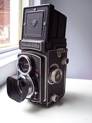
In the end I settled for my big Rolleicord medium format camera, the Leica M2 as the mainstay, and a small Nikon 35Ti ‘point and shoot’ for slide film. Altogether I packed about 70 rolls of 35mm film (Kodak 400 print film and Kodak E100 G Ektachrome) and 12 rolls of Ektachrome 120 film.

When I put all this plus my spare clothes, sleeping bag (a Mont 3-season), Thermarest and tent (a Walrus one-man lightweight job) in the pack it clocked up almost 20kg on the bathroom scales. Oh dear. I decided it would be a good idea to have a trial run to see if I could manage such a heavy load, and also to check out all this new gear to make sure it all worked.

Paul en route to North Era, Nikon 35Ti + Kodak Elite Chrome slide film

A couple of weeks later I took my 10-year old son Paul on a practice walk - a gentle overnight trip to the camping ground at North Era beach, in the Royal National Park south of Sydney. After a lovely apple pie and cream to start us off at the café near Otford, we set off along the clifftop track and down through the ‘Palm Jungle’ to Burning Palms beach and beyond. As well as being a pleasant interlude, the trip taught me a few valuable lessons - I discovered that the rain jacket was very sweaty and very fiddly to zip up, my boots were too big (more thick socks needed) and my backpack sat uncomfortably low on my back and I kept trying to hitch it up. My food choices seemed OK, but the trip also reinforced the fact that I would need to be carrying a lot of water – we consumed two litres in just a few hours of relatively easy walking.

Back at home, after a few last minute purchases and adjustments, I was now ready to go. All I had to do now was wait those last few weeks and days. And oh, how slowly they seemed to tick over. "Big trip coming up - are you excited??!" people would ask me at work. Well, no, not really. More worried about what might go wrong. And as I was to discover, plenty of things would go wrong.

[To be continued]

Tuesday, June 01, 2010

A taster of what's to come ...

Got about ten rolls of 120 film scanned now and some of the pictures are really impressive, even though I say it myself. This is one of the poor ones - I took it of Jambeyang, Yading, with the Rolleicord and Ektachrome. I had to wait ages in the freezing cold to get a glimpse of the peak through the ever-shifting clouds. Interesting to compare it to the Rock picture taken in the same place in 1928. In the modern picture you can see the ugly concrete track for the golf buggy 'bullet train' recently installed for visitors by the park management in the left of the picture. In the middle you can just make out the tents and huts of the Luorong grazing pasture, where official guides will now charge you 300 kuai to ride a donkey up to the lakes, an hour away.


Konkaling - Jambeyang

Sunday, May 30, 2010

The Yading outer kora: some background


Konkaling article, originally uploaded by jiulong.


In the spring of 1928, Joseph Rock made a visit to the three sacred mountains (Shenrezig, Jambeyang and Chanadorje) of the Konka Risumgongba range from Muli.

These three peaks of around 6000 m in height, are also known as the Konkaling peaks, and are now part of the Yading National Park. Rock had seen the peaks from a vantage point in Muli in 1923, and had persuaded his friend the Muli king to help him travel to the mountain range using his influence over the hostile local bandits. I have explained much of the background to these 'Holy Mountains of the Outlaws' as Rock described them, in an earlier article (here and here).

Suffice to say that the Konkaling mountains were a no-go zone for non-locals because they were the domain of a band of vicious Tibetan robbers ('the scum of the outlaws' as Rock put it) led by a bandit called Drashetsongpen. Anyone who trespassed among these peaks would be robbed and murdered by his gang of robbers, who also made regular excursions to rob and pillage nearby areas. The Muli king, however, had come to an arrangement with them, paying them off and allowing them free passage across his lands in return for not molesting his subjects.
Rock was supplied with a 'safe conduct' pass and a guide by the Muli king, and set off to visit the Konkaling peaks in March 1928.
Joseph Rock at Konkaling, 1928
His party included 36 mules and horses, 21 Nashi assiatants, and the head lama of Muli monastery to act as a guide. Rock describes the trip in an article in the July 1931 issue of the National Geographic, in which he claims to be 'the first white man to visit the Konkaling peaks'. He says other explorers and plant hunters such as Kingdon Ward had been in the area but had never got close enough to see the peaks in good weather.

Konkaling map
Rock approached from the eastern (Muli) side, dipping down into the stifling heat of the cavernous Shouchu river valley and then climbing out on the western side up to the village of Garu (now known as Galuo), whose tough Apache-like Tibetan inhabitants he compared favourably to the snivelling and servile subjects of the Muli king. Even these 'proud and virile' men were reluctant to escort Rock around the peaks because of the bandit threat, until Rock mocked them by suggesting he take some Garu women instead.


From Garu, Rock ascended through virgin spruce and fir forest and at higher altitudes rhododendron forest then crossed over a high pass to reach the mountains, and to make a circuit of the three peaks in the usual Tibetan Buddhist clockwise fashion. His first camp was at 15,300 feet below the scree slopes and glaciers of Chanadorje ('huge moraines resembling a vast ampitheatre'), where he says he got a great view when the clouds finally parted - 'revealing The Holder of the Thunderbolt - a truncated pyramid flanked by broad butresses like the wings of a stupendous bat'.
Chanadorje moraine by Joseph Rock, 1928

This place the locals called Konka Djra-nse, or Sea Dragon's Snout. This is where we joined up with Rocks circuit, although we had come from the western side. We also got great views of the whole face of Chanadorje at this spot, and it is odd that Rock does not include any photos of this impressive view of the mountain in his article. He only includes a picture of the glacier moraines at the foot of Chanadorje, and by the look of things there is much cloud about.
Chanadorje glacier moraines - north side


From the natural campground below Chanadorje called Shingara, Rock ascended a pass and followed a valley called the Saiyo Katso, which culminated in two smaller peaks known as Dzambala. We also followed this valley, which gave great views of the side of Chanadorje, and also gave glimpses of the sliver-like side profile of Jambeyang further to the southwest.

This valley also had a small hanging valley within it, with a beautiful small lake. At this point Rock's party were commanded to try collect some local wildlife (he says he shot some snow pigeons), but they objected to the taking of life. Rock found this amusing, as the locals seemed to have no qualms about taking human lives. They also came across a few Konkaling Tibetans skulking among the trees. They had been scared by his rifle shots, assuming that humans were being shot ('since no one hereabouts wastes shot and powder on useless pigeons as we had done'). The head of the valley was blocked by an imposing black vertical wall of rock below two minor peaks. I presume this is the Yaka Pass that Rock refers to. We just called it The Wall, and it looked like a very steep ascent to a knife edge ridge.

For someone who regularly used plenty of florid prose, Rock is quite restrained in his description of the rigours of the journey around the peaks, saying only that 'our journey proved very arduous'. He describes the crossing of the Yaka Pass under a torrential downpour, with no trail to follow, and the mules and humans unable to find a good footing on the slabs of schists covered in rainwater and slippery grey mud. We had exactly the same experience, summed up by this paragraph: 'Climbing at such altitudes is difficult enough in good weather, but in a terrific hail and rain storm, with a howling gale driving the icy pellets into one's face and making one gasp for breath in this rareified atmosphere, it is doubly disagreeable.'
After crossing the Yaka Pass, Rock says he camped at the foot of hanging glaciers of moraines on the southern slopes of Mt Jambeyang. We also camped here, although it was far from an ideal camping spot. Rock says his entourage sought shelter in a cavelike space under an overhanging cliff, where pilgrims had erected chortens.
Joseph Rock at stupa shelter, Konkaling, 1928
We also saw this sacred site, which was pretty much unchanged from the photograph published by Rock. There was still a makeshift wall and a couple of chortens in disrepair. And like Rock, we also spent the night listening to the thundering noise of falling blocks of ice, tumbling down from the heights of Jambeyang's glaciers.
It was near here that Rock says he encountered the dreaded bandit chief himself, Drashetsonpen, who was also making a circuit of the peaks (perhaps in expiation of his heinous crimes). His gang had sullen faces, hinting at looting and murder.
Rock sat down in the pouring rain with this bandit leader and his thirty followers, and shared some rancid yak butter and and cheese. They made little conversation except for a reassurance that Rock would not be molested.

Konkaling chorten cave


The next section, a difficult walk along scree and snow under steep cliffs, is given little mention by Rock, except to say that his party shot a wapiti, but they were unable to bag it because the body rolled down the steep slope into the Lawatong valley far below.
The trail then makes a sudden turn northwards around the cliff shoulder, and Rock describes this new valley as Yetchesura. We found it quite easy going after the steep scree, but Rock complains that that 'the enormous slabs as smooth as a billiard table, covered with large patches of ice and snow made travelling most disagreeable'.
HIs next camp, like ours, was by one of the larger lakes in the area, a long thin lake he calls Russo Tso ('where dwell the worst of all the Konkaling outlaws').
Before we reached this we had to cross two further but relatively easy passes. After the first we came down to a fertile flat area of grass, in the middle of which was a large slab of rock as big as a house, which has become know as 'Rock's rock'.
Joseph Rock at Konkaling, 1928
He includes a picture of his entourage sitting around this huge slab of schist, which he says must have fallen from the lower slopes of Mt Jambeyang.
While camping next to the lake, Rock says his guides were nervous, pointing up at the high slopes above them where Tibetans (presumably bandits) could be seen in the rocky ramparts, watching them.
Rock's rock, Yading

From this lake, Rocks party climbed up to another pass with several exits (we called it the three-way pass), which divides Jambeyang from Shenrezig. This pass connects with the Konka Den valley, which is now part of the main tourist trail of Yading, giving views of all three peaks. Rock descended with his party, and his visit to and stay at the Chonggu Monastery are described in my earlier post (here).

Friday, May 28, 2010

Yading outer kora - we did it!


Just back from the trip to Yading, where we completed the outer kora, or circuit. It was a lot tougher than I expected, especially the walking at high altitude (4000+ metres). We followed the route suggested by Lloyd Raleigh at his travel blog, but we found the going very hard in the wintery and icy conditions of mid May. We learned that the best time to do the kora would be October, as most of the potential local guides are away in May looking for the lucrative caterpillar fungus (congcao). Anyway, we managed to complete the trip and saw many of the sights described by Joseph Rock, such as the cave stupa, Rocks rock and the scree slopes at the back of Chanadorje.
I will post more pix and a more detailed route description starting from next week.

Wednesday, May 05, 2010

Muli king in B&W - by Joseph Rock


Muli king, originally uploaded by jiulong.


So this may the last post for a while - on Friday I will travelling to Chengdu, then on to 'Konkaling' (Yading) by bus, via Kangding, Litang and Daocheng. Hope to be at Yading by Wed 12th May, from where we (me and Peter from Geelong) hope to do a large circuit [kora] of Chandorje, Jambeyang and Shenrezig. This will be repeating Joseph Rock's visit of 1925, but doing it backwards -starting from the Chonggu Monastery, which was the furthest point he reached on his trip from Muli in the east.
We're expecting the trip to take five to six days of actual walking, and that means a lot of food has to be carried as we will be up at 4000 metres with no places of residence, let alone villages en route.
I'll be taking my Rolleicord medium format camera, and I hope to capture some nice images of the peaks, weather permitting. I will also be bringing my trusty Leica M2 for 35mm prints - and a little Nikon 35Ti point and shoot camera for slides. So watch this space - I will try post some updates along the way - but the great internet firewall may not allow me to do much, seeing as it blocks blogspot.
Joseph Rock at Konkaling

Muli king in colour (autochrome) - by Joseph Rock


Muli king, originally uploaded by jiulong.

Sunday, May 02, 2010

Konkaling - Chandorje and Jambeyang

Well, only four days to go ... 'm a bit worried by the amount of gear I have in my pack - and still there are items to add. Hope we can find a horse or two to carry them.

Monday, March 29, 2010

The strange life and mysterious death of Margo, Aussie 'queen of the Tiger Leaping Gorge'

I never met Margo Carter, or at least I don't think I did. She took up residence in the Tiger Leaping Gorge in the mid 1990s, whereas my one and only visit to this scenic wonder of the world was in 1994, presumably before she arrived. I am glad I visited when I did, before the road was put through and it became a must-do feature in the Lonely Planet guidebook for China.
From what I gather, Margo was a bit of an eccentric character, who hailed from Bendigo in Victoria and who had worked in market research and as a teacher in Sydney before travelling in China. She obviously was drawn to the scenic splendour of the Tiger Leaping Gorge and the charms of the local area, because she settled down to live there, and set up home with a local ethnic Tibetan guy, Sean, aka Xia Shan Quan, in 1996.
Sean had already set up one of the pioneering guesthouses in the gorge, at Walnut Grove, and was considered to be a pro-environmental kind of guy. His main guesthouse competitor, 'Woody', seemed to be more of an entrepreneur.
Margo did what I and I guess many other people have often dreamed of - dropping out and opting to live in a place far removed from civilisation in a remote part of Yunnan. No roads (at least to start with), no shops, no TV and little electricity. Not even a flushing toilet.
In reality, it can hardly have been a quiet life. With a steady flow of western backpackers traipsing through the gorge, Margo must have been busy trying to encourage them to stay at the guesthouse she ran at the entrance and at Sean's at Walnut Grove.
Reports from traveller's blogs and the various online travel forums suggest she was a bit of a Jekyll and Hyde character. Some describe her as a wonderful host, welcoming and very helpful, going out of her way to guide people along the gorge and help them avoid being ripped off by some of the more dodgy operators along the way. Other accounts describe her in varying degrees as aggressive and abrasive or just 'crazy', while some vistors found her withdrawn and dismissive. I guess it can be hard trying to put on a welcoming face to show to the world as it tramps through your home every day, but even so, it sounds like Margo was sometimes exhibiting a TLG version of 'cabin fever'.
She married Sean, and his website says he has three daughters, though I can't imagine what it would be like for a westerner rearing children in such basic conditions. Apparently Margo later split up with Sean, and some reports say Sean went to the US for a while, and yet recently they appear to have been back in business together, running their guesthouses and guided treks in the gorge.

Living in the Tiger Leaping Gorge for the last 15 years, Margo must have witnessed some profound changes and experienced a lot of dramas in her time. What started off as a single precarious mule trail through the gorge explored by a trickle of adventurous backpackers was gradually but relentlessly transformed in the 1990s. Dynamite blasting created a 'scenic highway' through the gorge that carried convoys of tour buses full of Chinese day trippers, down from the tourist boomtown of Lijiang. There were still plenty of western backpackers doing the 'higher' footpath trail, however, and Margo must have dealt with a fair few of the reported incidents of westerners injuring themselves or being killed by falls in the gorge, or being attacked or in some cases just disappearing along the track and being searched for by fraught relatives.
Margo featured in many a travelogue and TV show, was mentioned in the Lonely Planet guide. Like the eccentric Dr Ho running his herbal tea clinic outside Lijiang, Margo became one of the local characters. She was also frequently interviewed by western journalists about the likely future of the gorge after it was rumoured that it would be the site of a massive dam to tap the hydro potential of the Yangtze at one of its narrowest points.
Was she happy there? Well, aside from the reports of her occasionally cranky character, one of the last journalists to have interviewed her in recent times (a reporter from the Financial Times re-visiting the gorge to see how it had changed) reported that she seemed disillusioned by all the development and commercial exploitation going on in the gorge. It must be heartbreaking to settle in such a beautiful wilderness and see it slowly transformed into an overdeveloped tourist trap.

A few weeks ago I heard from a friend who lives in Yunnan that Margo had died. No details. I was vaguely curious, but thought little more about it as I was so busy with work and family matters.
Then in recent weeks, as I was planning to do another trek in South West China, I came across the bizarre details of what apparently happened to Margo, and how she died while doing a solo trek far away from the gorge, around the holy mountain of Kawa Karpo (Meili Xueshan) in the Deqin region of far north west Yunnan. I had been considering doing this 'big' kora (circuit) trek myself, but gave up on the idea after reading a few accounts of how strenuous it was - a full-on, 10-day trek from the Mekong (Lancang Jiang) over the high mountain pass of the Doker-La to the Salween (Nujiang) and back over a more northerly pass, the Shu-La, again to return to the Mekong. (This is the Joseph Rock connection - his account of an extended trip along this route appears in his article 'Through the Great River Trenches of Asia' in the August 1926 issue of National Geographic).
I'd already done some sections of this trek, and found them tough, and I passed on the idea, partly because I lacked the time, but also because I considered the scenery not perhaps as good 'value for money' as that to be experienced in the Yading area, although it certainly is spectacular.
I got much of my information from a website set up by a Yunnan-based British trekking guide called Richard Scotford, who used to run a trekkers lodge in Deqin. In an article Death on The Kora, Richard describes a strange encounter he had with Margo while he was leading a group of trekkers over the Doker-La pass on the first leg of the Kawa Karpo kora in October 2009.

His group were surprised - to say the least - to be passed by a lone western woman traveling at speed (alone, that is, except for her dog and a local guide with a horse, left trailing well to the rear) and they noted that she was only lightly clad for the trail. Not only that, but they were taken aback by how rude she was to the trekking group, refusing to talk with them at all during their brief encounter on the trail.
Things got stranger later in the day when they saw her again and she chose to camp alongside them, but again was uncommunicative. That was until she started saying that she would 'turn them in' to the local authorities and warning them that they would be turned back at local police checkpoints further up the Salween (Nujiang) valley and the local Tibetans would shun them. The group were un-nerved by her unfriendly and bizarre behaviour (she would only talk to them in Chinese at one point) and her apparent threats.
Margo left early the next day and they never saw her again. In fact, they were some of the last people to see her alive. Richard is an experienced trekker in the region and he thought the claims that Margo made to them about the authorities were implausible and hard to believe. He was proved right. There were no roadblocks, and after some cautious checking, his group continued on uneventfully into the Salween valley, where the local Tibetans were friendly and helpful, and soon the trekkers had put the memory of this odd encounter with the 'mad' western woman out of their minds.
However, a few days later when they came to do the strenuous return leg of their kora, back over the high passes to the Mekong valley in the east, they got a shock. After the exhausting climb up to the exposed Shu-La pass, they descended on the eastern side to find Margo's guide waiting at the first small settlement high up on the mountain. He was frantic and said he had not seen Margo for two days. She had gone missing at some point after leaving the guide behind when she hurried along in front to attempt the pass by herself.

The guide had assumed she had gone on ahead, and he summmitted the pass and continued on down in the expectation of catching up with her on the other side. By the time the trekking group arrived he had already been waiting for her for two days. Richard later came to believe that Margo had taking a wrong turning at the confusing terrain of the Shu-La pass, where with three valleys to choose from it would be an easy navigation error to make. This would have seen her descending into a wrong 'dead end' valley and ending up be-nighted high on the mountain with no shelter and no warm clothes, no food and no means to make a fire. He doubted anyone could survive two nights out in the frigid high alpine environment.
Not knowing where the strange western woman might be, the trekkers continued on down. Richard then goes on to explain some of the rumours they heard once they completed their trek. Some rumours coming out of the Tiger Leaping Gorge said that Margo had been murdered by a local trader after a deal to buy some of the expensive and highly-prized local medicinal mushrooms had gone sour. Richard rightly points out that this scenario seems improbable, given the remote and inconvenient location of her disappearance.

After an extensive search by local residents and police, Margo's body was eventually found several weeks later on a remote trail at a large tree near the Shuo-La pass. Her small dog was also with her and was still alive. It appears likely that she simply underestimated the harsh conditions of the trek and the difficulty of the terrain that she would encounter. As another very experienced Australian trekker, Clem Lindenmayer, had discovered a couple of years earlier on the Minya Konka kora in Sichuan, solo trekking in Kham can easily be fatal.
While Margo Carter was well known as a guide on the Tiger Leaping Gorge, the conditions on the Kawa Karpo kora are a whole world away and require a much higher level of trekking skills and experience.
So was Margo just an unfortunate victim of misplaced over-confidence on a tough alpine trek? If so, why was she so hostile to the western trekkers she encountered on the way? Richard also mentions that Margo was seen by some other westerners in Zhongdian shortly before she started her trek, and she had advised them to listen out for 'some big news' from the kora at the time of her trek. What does this mean? Did she intend to walk off into the wilderness and do an 'Into the Wild' or something dramatic?
Whatever the truth, it's a baffling and sad end for an eccentric character who 'lived out the dream' in one of the world's most remote and alluring locations.

UPDATE OCT 2014: I have just done the Shu-La pass and am more mystified than ever about the disappearance/death of Margo. The route is quite clear all the way to the pass, and it would be hard to get lost unless you purposely went "off piste". The trek over the pass is strenuous, but not impossibly so. It would even be possible to cross the pass in  'ordinary clothes' as many Tibetans do, weather permitting. I'm also puzzled by the claim that her body was found by "a large tree" near the pass. As you can see, there are no trees whatsover within about a mile of the pass. Perhaps they meant much further down. The approach to the pass from the Wichu valley is through a wooded gully and is very strenuous/tedious (see my blog about the crossing here). There are also trees much further down on the eastern Yunnan side of the pass, but there is also a shelter at the treeline.

Here's a pic of some mums and infants in light clothing, just after crossing the Shola Pass with me in October 2014.

UPDATE April 2017: As you may have seen I made a return to the Shola last autumn and in con to my first crossing the weather was pretty bad. It was freezing cold and the low cloud/mist meant visibility was poor. I can now see how easy it would be to get disoriented and lost crossing the pass, and how quickly you could sucuumb to cold if not properly equipped.