Monday, July 18, 2016

Trekking partners wanted for my next challenge ... the west face of Kawakarpo


After my recent 'success' going around the Yading  outer kora in seven days, I am itching for a new challenge. I was thinking that I had done it all when it comes to treks around mountains ranges such as Kawakarpo and Gongga Shan. But I was wrong. There is one unvisited area that has attracted me ever since I saw it on Google Earth - the western glaciers of Kawakarpo.

As you may know, the eastern Minyong glacier of Kawakarpo (Meili Xueshan) is now a tourist trap, visited by hundreds of trippers by bus and a short walk every day from Feilai Si. The three western glaciers, however are totally inaccessible by road. The only way to get to them is by taking a long detour from the already remote Kawakarpo kora circuit up untravelled valleys. Since the outer kora already takes at least 10 days, this would make a minimum of two weeks - possibly more, if you did it as an add-on to the whole kora. Add to this the fact that the west side of the mountain is in out-of-bounds Tibet means that few - if any - westerners have ever visited or  the main western glacier of Kawakarpo. So that's my next challenge, and I'm looking for trekking partners to join me on this exploratory trip.


On Google Earth it appears that the only way to get to the biggest and most impressive north west  glacier of Kawakarpo is via a long detour to the south, up a steep, narrow trackless valley, starting from the Wi Chu (Oui Qu) river near Laide (see the yellow trail, above). Laide is a waypoint on about Day 8 of the usual kora). The side trip to the glacier looks like a minimum of a four day round trip from Laide.

The encouraging news is that there appears to be a settlement at the glacier moraine - so there must be some way of getting in there.  More promising is the fact that there appears to be  a track that acts as a shortcut, running right over from Chawalong - (see the blue trail, above). This would make sense as it looks like a 2-day journey rather than what would be a four day journey from Chawalong going via the usual kora route of Gebu, etc. The bad news is that this shortcut goes over a steep mountain ridge:


A bit of searching on the Chinese language trekking blogs shows that a few intrepid hikers have made their way over the mule tracks from Chawalong - and they are calling it the Bogong Mountain Pass (伯贡山垭口) to Jiaxing (甲辛) village. It sounds like a bit of a rough trek - but is do-able.

I'm now reading up on the journey - with a view to doing this in October. If you are interested, contact me via beijingweek -AT-gmail.com. It will require at least 8 days from Deqin, and I'm planning to set off in early October. The trek will be pretty strenuous and you will have to be experienced & equipped/capable  to survive camping/lodging in very basic Tibetan farms for a week.

UPDATE 23/7/2016:

After researching a few Chinese hiking forums and blog posts it seems that Jiaying (the glacier settlement of four houses) is being regularly visited by a few intrepid groups of Chinese visitors to Chawalong. There seems to be a couple of routes - a direct path over the ridge that takes about 8 hours - and an indirect route  that uses a newly-created road on the ridge above the village of Longpu. This is part of a new road that the Chawalong authorities are creating to Jiaying - their hope is to turn it into a lucrative tourist destination to rival Minyong glacier on the eastern side of the mountain. The road is a branch from the Kawa Karpo kora route at the Tangdu La pass.

For me these routes pose the obvious problem that they are within Tibet, and this requires an impossible-to-achieve Tibet entry permit to get past the checkpoint south of Chawalong. (I got around this in 2014 by sneaking through the border checkpoint on the back of a motorbike at night, but it seems the checkpoints are now open 24/7 and the border guards - bianfang - becoming more vigilant for foreigners). My Plan B is therefore to try hike in from the Yunnan side. This involves doing the last section of the kora in reverse - up to the Shola Pass. I'm familiar with this route, and it should pose no difficulties unless any pilgrims take offence at someone doing the kora the wrong way round. But I'm not doing the kora - from the Shola there is a clearly visible track that skirts all the way below the ridge to the two glacier sites. Most of it can be seen quite clearly on Google Earth (see below, marked in green). There also appear to be some huts along this route.

My plan is therefore to take this route to Jiaying. Once there I have the option of trying to sneak out through Chawalong - or simply returning by the same route. There is also a longer, less steep track that goes back  and joins up with the kora route (marked in yellow).

If I do get past Chawalong down the Nujiang to Yunnan I plan to re-walk the Dimaluo-Cizhong hike via the She La pass and spend a little longer in the marvellous Sewalong valley. My hiking dates are around early-mid October, departing Deqin.

View from the north west: the well-trodden Kawakarpo Kora is marked in red. The tracks to access the western glaciers are marked in green. The longer alternative route is yellow.

Saturday, July 16, 2016

East of the Himalaya Mountain Peak Maps: Tamotsu Nakamura

I just got one of these limited edition books from the Sydney branch of publisher Kinokuniya. It's an absolute gem, packed with great photos and very detailed maps of the mountains of Eastern Tibet. That means it includes areas such as Kawakarpo, Gongga Shan and Yading. In true Japanese style it is beautifully presented and the 'quality control' is 100%. Mr Nakamura has travelled more than any other explorer in eastern Tibet in the last few decades and this really is a comprehensive summary of his research and filed trips. I will be spending many an hour poring over it and planning new treks. Sadly, as Mr Nakamura makes clear in the introduction, access to the area is now becoming difficult due the increasingly tight controls being applied by the PSB. Please let's hope that is only a temporary situation.


Friday, July 15, 2016

Thursday, July 14, 2016

17 Questions You Always Wanted to Ask About the Yading Outer Kora


I get a lot of email inquiries via this blog asking about doing the Yading kora. I'm leaving this here as a reference to answer some of the most common questions. If there's anything I've not covered, let me know!  

1. Why do it?

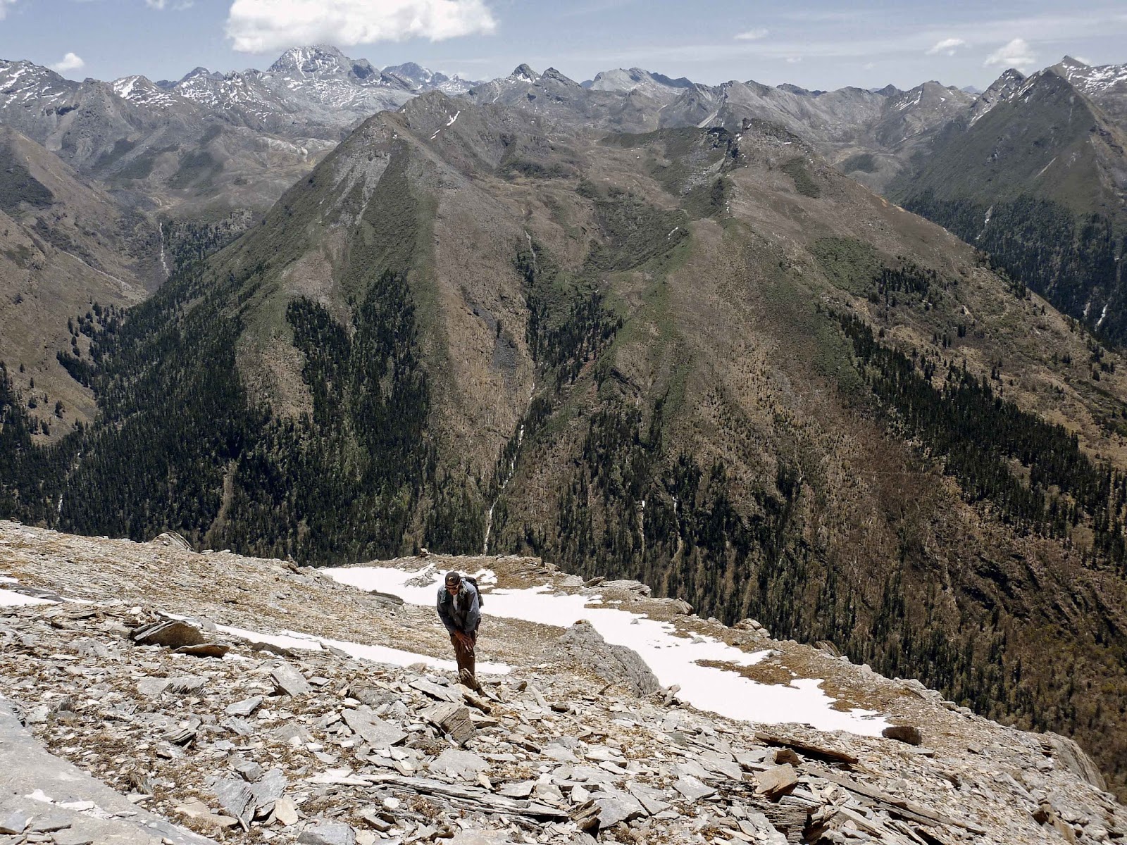
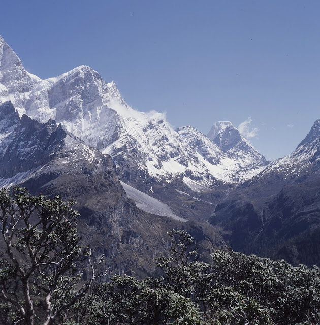
How often do you get to see three amazing and very distinct mountains in close proximity and have them all to yourself? This is a trip through a little travelled and unspoiled alpine area where you will meet few if any other people for a week. As well as the spectacular alpine scenery (including glaciers) the area is a treasure trove of rare flowers, plants and tree species. You will also see a wide variety of wild animals and birds. Yading is also rich in Tibetan Buddhist culture. The kora itself a sacred path for Tibetans, but for some reason the outer kora has very few pilgrims compared to more popular nearby routes such as Kawakarpo in Yunnan. As well as being a pilgrimage, the kora is also a great physical and mental challenge. Can you survive in the wild without access to shops, houses, electricity, roads - and the net or mobile coverage - for a week?

2. How long is the trek? 

I really don't know! I'd guess about 100km, but thinking of it in terms of distances from A to B is unhelpful anyway. The full kora takes seven days at a moderate walking pace of a fit adult, allowing for an average of five hours walking per day. You could do it in five days (we did) if you walked flat out, but this would be horrible, exhausting and leave you little room for error or seeing and exploring the many sights along the way.

3. What's the terrain like? 

It's mostly above the tree line on open hillsides and mountain slopes - that means walking on sometimes steep slopes exposed to the elements - wind, rain, snow and sun. You'll be walking on terrain covered by low scrub along muddy trails, up scree, on glaciers (if you want to) through stream beds, over makeshift log bridges, and occasional scrambling up rock and clay inclines. There is some walking through forest and also some walking along exposed alpine trails where you will need a head for heights.

4. Fitness? Experience? How difficult is it? 

 It's not a technically difficult walk apart from the odd sections that require a bit of scrambling. It can be done by a reasonably fit person who has stamina and can put up with bad weather, rough terrain and most importantly, altitude. It's not a walk for kids, your gran, or anyone with health or disabilities that limit their exertion - and it's not something you'd do on a whim and without proper gear. You need to be experienced in trekking in wild country and also able to endure some serious exertion, slogging up hills to altitudes of almost 5000m. You need to be able to balance on boulders, slide down muddy slopes and endure rain and strong winds. That makes it sound really arduous, but much of it can be pleasant and relaxed in the right conditions - I'm painting a worst case scenario. You will need to be self sufficient and carry all your food and camping supplies. This means either carrying a 15kg backpack (I couldn't do it) or having a porter with a mule to do the heavy lifting. It also requires some psychological robustness, especially if you are travelling alone (albeit with a guide) and can't speak Chinese. What was that moving outside the tent? Did I leave the gas on?

5. Maps? Route finding? 

There are no small-scale local and accurate topo maps of Yading that I know of. Some aerial pilot charts cover the area but they don't have enough details and the tracks/roads etc are hopelessly inaccurate. There are some Chinese hiker-compiled sketch maps (not to scale) and larger scale Chinese maps of the area, but I have seen nothing comparable to the British Ordnance Survey standard of maps. However this is the age of Google Earth and its zoom/3D functions allow you to get excellent resolution and scale for the entire Yading kora (if you know where to look). I have included screengrabs on my blog. This shows you can visualise even individual huts along the kora with Google Earth/Maps. And surprisingly the locals do not have access to such detailed views because Google is blocked in China - so take printouts or keep copies on your phone/tablet.
But even with maps the route finding is not straightforward - the trail is unmarked in many places, except by occasional piles of stones. Sometimes there are confusing multiple trails, some leading down dead ends or to areas beyond the kora. Please don't ask me about GPS and waymarkers. I'm a technophobe, I know nothing.

6. When's the best/worst time to go? 

There are only two narrow windows in the calendar when the kora route is walkable and with chances of clear weather to see the mountains: late spring (late May, early June) and autumn (September and October). The best time to go is autumn. The rainy (monsoon) season starts in early June and lasts until the end of August. At this time you will likely get low cloud and constant rain, with no views. Believe me, I've walked it for seven days and you need good waterproofs.
In winter and up to May the route is snowed in and you can expect subzero temperatures at altitude. Conditions underfoot will vary from treacherous to impassable. Snow and ice return from mid October. Even at the peak periods the weather can be highly variable - it may be scorching in the rest of Sichuan but we have had blizzards in Yading in June.
The other two factors to consider in timing are the peak Chinese holiday times of the Golden Weeks (around 1 May and 1 October) when Yading will be packed with visitors (Warning: entry is sometimes restricted to online pre-booked ticket holders during these periods).
Hiring a guide will be difficult in spring because it is the season for harvesting the lucrative caterpillar fungus (chongtsao) which means that locals can earn a lot more from foraging than guiding you.

7. Do I need to hire a guide? 

Yes, yes and yes. Firstly the route is not easy to find or follow, especially if there is bad weather such as mist, rain and snow. Secondly, the kora is a trip into a very isolated infrequently travelled region where there are no villages or sources of help should you have an accident. If you became stuck because of a sprained ankle or got lost due to bad weather, you could not expect there to be any 'passers by' to render assistance - at best there might be one or two groups a week doing the kora. Thirdly, a guide is needed to liaise and communicate with local people you may meet en route, especially if you don't speak Chinese (or the local Tibetan dialect). Yading Tibetans are generally friendly and helpful, but misunderstandings can easily occur over trespassing or expected payment for services such as food or assistance. A guide will take care of all that for you - and also carry your bag! The best place to arrange guides is though the guesthouses at Yading, or possibly Riwa. Expect to pay 300 yuan a day for one guide and mule. Few people understand English so you will need to get someone to translate your plans to the guide.

8. Does anyone speak English? 

No.

9. Is there phone/wifi/internet coverage/power to recharge my phone on the kora? 

No.

10. Fees, permits, restrictions? 

Expect to pay 300-400 yuan for admission to Yading National Park. The admission ticket alone is something like 250 yuan, and you are also compelled to use a 80 yuan shuttle bus to get there from Riwa (no private cars or buses. taxis etc allowed). There is also 80 yuan fee for the electric buggy service that runs up to Luorong from Chonggu monastery (though you can walk this bit). Recent reports from Yading have stated that the local government has banned trekkers from entering or leaving Yading by unauthorised routes such as the popular Lugu Lake/Muli/Galuo trek and the even moe popular Devil's Canyon side trek. I've also read that officially 'free camping' is no longer permitted but I've never seen anyone who would enforce these rules beyond the popular Luorong valley. However I have found park staff there to be very officious enforcers of the rules.

11. How do I get there? 

By bus you can travel from Chengdu to Daocheng in two days via Kangding (stopover) and Litang. Then a private hire van or motorbike to Riwa aka "Shangri-La". As I mentioned, from Riwa you can now only enter the park by the official shuttle bus (but you could hike in from Riwa up the valley to Chonggu in one day). It's also possible to get to Daocheng from Yunnan via the other "Shangri-La" (formerly known as Zhongdian). The bus travels a twisting road in one day, via the town of Xiangcheng. If you want to get to Daocheng in an hour, there are daily flights in to Daocheng-Yading airport (40km north of Daocheng) from Chengdu. I tried it, it's a great flight.
By the way, this being a blog about Joseph Rock I should mention that you could follow in his footsteps and get to Yading on foot, from Muli via the Shuiluo valley to the east. In the era of the good road from the north, I don't know many people who does this nowadays. Some Chinese trekkers do part of this route from the Shuiluo valley (often starting from Lugu Lake), which they call the 'Rock Trail'.

12. Accomodation? Do I need camping equipment? 

Increasing visitor numbers is putting pressure on accomodation in tiny Yading village, which has only about six guesthouses. Book ahead, don't expect to get a place if you arrive without a reservation. Many people now stay in Riwa, where there are more guesthouses, a youth hostel and some posh hotels. On the trek itself you will definitely need a good tent and a winter sleeping bag. There are no villages or places to stay on the kora route except for some decrepit bare stone shelters that are in varying rates of disrepair (some don't have roofs). So you will be camping and must be prepared for severe conditions including snow, hail, flooding rain, thunderstorms etc. You may be lucky some nights and your guide will arrange to sleep in one of the shelters or temporary tents used by the locals who are foraging for chongtsao - but don't bank on it, even as an emergency backup. There are suitable grass sites for camping on each section of the trail, all with sources of water (that should be purified).

13. Do I need to take food and water? Stove? 

You must be self sufficient in food for seven days. There is nothing available en route. One or two of the temporary Tibetan herder/forager sites might have a makeshift shop selling noodles and cans of cola. But do not rely on this. You will need to cook your food and that means a camping stove (unless you are prepared to forage for firewood and get a good fire going - possible, but hard work). Stoves and camping gas canisters can be bought in the outdoor supplies shop in Daocheng's main square. There is only a very limited stock of basic food and supplies in Yading village shops. Do your last shopping in the supermarkets of Daocheng or Riwa. There is reasonable water available from streams en route - I used iodine water purifying tablets and survived without any tummy troubles. For food I found that instant noodles did the trick for me most days, with just a few variations on dehydrated meals and a few extras. For lunch and snacks I relied on wholemeal crackers and cheese, which kept surprisingly well for a week. If you want to eat with the local Tibetans they live on tsampa (barley flour), yak butter tea and dry momo bread, with occasional bowls of spicy noodles.

14. What other gear will I need or be useful? 

See my blog post. Good waterproof boots (not shoes) and rain gear are the most important items

15. Altitude sickness? 

Yes, definitely, if you are coming from outside. Expect thumping headaches, waking at night with a dry mouth and thirst - and lethargy - wanting to lie down and doze off when you're walking. Altitude also means that your uphill walking ability is massively impaired. What would be a gentle uphill slope at sea level becomes a gut-busting struggle that leaves you gasping for breath after 20 paces when you arrive in Yading. The rule is, I believe, to acclimatise slowly at a rate of about 500m ascent per day above 3000m. Since Riwa is about 3500m that means at least three days. I found that the Magic Bullet for me in terms of altitude effects was Diamox. You have to start taking it two days BEFORE you arrive at altitude. I was fine with this and a couple of weeks of physical activity training before the trek. Meanwhile, I saw otherwise-fit Chinese guys half my age really struggling to cope with the altitude. Their Chinese Traditional Medicine remedies didn't seem to be helping them.

16. Safety? Dangers? 

Yading is not an inherently dangerous place. The main hazards that you face on the kora are the same as you'd face on any comparable trek in alpine areas: weather and the elements (cold, exposure, exhaustion, heatstroke, sunburn, lightning strikes) and the terrain (falling off cliffs, tripping over and breaking a leg or spraining an ankle). There are no especially dangerous rivers to cross, but some creeks and streams have to be surmounted by logs or makeshift wooden bridges. In winter there are ice and snow slopes on the passes. As I mention in my blog there are two particular sections of steep track on Days 3/4 at the back of Jambeyang that are quite exposed and would result in serious injury/death if you slipped from them. There are no particular nasty creatures such as bears (well there are reputed to be bears, wolves and leopards but I never saw any). There might be a vicious Tibetan dog with some of the local nomads, though I never encountered any in this area (unlike other places such as nearby Muli and Deqin). If you're travelling with mules you might either fall off or get kicked by them (stay well away from rear). The local Tibetans are mostly friendly, honest and helpful if encountered in remote areas, but can be a bit gruff and unsympathetic if they have been exposed to tourists at Yading.
If you do have a serious incident and require help or evacuation, the Yading authorities now charge a basic fee of 20,000 yuan for providing 'mountain rescue' services. I take out travel insurance (with outdoor activities extra cover) but I've always wondered if and how they would med-evac me out of Yading if I got stuck there.

17. What about the 1-2 Day 'Inner' Kora? 

Not much fun if you ask me. The first half, up Luorong valley to the pass between Jambeyang and Shenrezig, has some great scenery but you have to share the route with 5000 other Chinese tourists, some on horses or even being carried up on sedan chairs to the two lakes. The track is crowded and you sometimes have to wait for bottlenecks to clear or to pass slow walkers on narrow sections. Some visitors play loud music on their phones. Frustrating. Luorong valley is also spoiled by the recently built huge concrete road that carries electric buggies up with tourists from the reception point at Chonggu monastery. The second section, beyond the pass round the back of Shenrezig is better, but much of this is slog along churned-up muddy track through bushland, without any great mountain views. The mini kora involves crossing another pass before returning to Chonggu monastery. Sprightly Tibetan grannies walk this mini kora in a single day - but it's quite a stretch if you're not acclimatised. Best to allow two days and stay overnight at the huts/campsites between the first and second passes. See my blog for Day 6 and 7.

Photo: Peter Jost

Wednesday, July 13, 2016

Tuesday, July 12, 2016

Yading Kora Trek Diary: Day 7 - 7th Pass to Chonggu

Summary: An easy final day, crossing the last pass and then downhill all the way back to the starting point of our circuit, Chonggu Si monastery.

My night in the filthy hut almost killed me. Not because of the cold or the smoke and carbon monoxide from the fire, but a falling wooden beam that almost brained me. After worrying throughout the trip about coming a cropper slipping down steep mountainsides or being swept away in torrential rain-flooded rivers, my only brush with danger was  when I was narrowly missed by a heavy wooden supporting beam in the shed that Yue Qiang knocked over while cooking. It weighed a ton and slammed down right next to me - and no doubt would have caved my head in if it had been one foot closer. It was all over in a second and weirdly after a couple of moments of delayed shock, I didn't give a toss. It had happened - I'd had a very near miss and that was it. Nothing more I could do about it!

I emerged from the hut on Tuesday morning, exactly one week from the day we had set off from Chonggu monastery. We were just below the final pass, which we could see was festooned with prayer flags even from our starting point lower down. The weather had cleared up a bit - the rain had stopped, but we were still surrounded by rising mist as we packed up our bags outside the hut. Birds were singing in the surrounding bush and I recognised the calls of what to my Australian-attuned ears were 'European' species -  blackbirds, wrens and thrushes. I felt a twinge of homesickness for England at these birdsongs from my youth, but it also felt a bit out of place hearing the sound of birds in Tibetan mountains that I associated with English country gardens.


The  porters arrived and rounded up the mules from the surrounding hillside. They put saddle packs on them and fed them with the leftover momo bread that they had cooked up. While they were packing up, I did a final Video Diary for the film crew. They tried to make me say that this was the end of an era and that I had finally completed my epic quest to walk all the expeditions in the footsteps of Joseph Rock. This wasn't really true because I'd had that satisfaction when I completed the KawaKarpo Kora in 2014. If I was being honest, this trip was just a repeat, for fun. I'd already 'done' Yading in 2010.


At 9am, after ensuring we had our rain ponchos handy, we set off up the hill for the final pass. I followed the lead of Gong Que, who as usual took his own idiosyncratic 'off piste' route round the side of a heather-festooned outcrop that took us into a No-Man's Land way off from the track. Gong Que had a funny but sometimes anarchic Tibetan sense of impulsiveness. He would dart off here and there for no obvious reason other than to explore a side track or photograph some flowers. Sometimes this would yield unexpected rewards, but all too often it just led to dead ends and us getting stuck. He was supposed to be my guide but he was not local - he was from Kangding - and it was usually me pointing the correct route to him, not the other way round. Gong Que reminded me a bit of the hapless Stunt Man character from the Fast Show: "You want me to walk over this steep drop without a safety harness? Righto chief!"


It took us only an hour of climbing to reach the final pass, from where we had a great view back over the "Here Be Mud'" territory that we had squelched up the previous day. There was a sign near the top warning pilgrims not to dump clothes or trinkets at the pass - and yet it had been ignored and the passage over the ridge was still festooned with flags and old shoes and beads.


Over the other side of the pass we could see the route descending down a green valley all the way to the forests above Chonggu Si. And thus I set off on the final stretch of kora - the descent to Chonggu Si.

It was a fairly easy route and the rain held off for most of the morning as I tramped down stream beds and over well-worn tracks in pasture. I was mostly walking alone as we had split up into separate groups to walk at our own pace. Gong Que was away in front somewhere, I was in the middle and the sickly film crew guys were lingering behind with the horses they had ridden for much of the kora.


It was a long plod down to the tree line, and there wasn't much to see on the way, except occasional glances back to the pass. We passed a couple of stone huts about half way down and then entered thicker bush that eventually morphed into the fir forest. It was here I had my second near miss of the trip, when I narrowly missed having my eye poked out by a protruding sharp broken tree branch.


The final hour or so through the forest seemed the longest, and I experienced a strange mixture of relief and sadness when I finally spied the big flag-strewn stupa that marked the tourist boardwalk lookout point at Zhuoma Tso lake above Chonggu monastery. I walked the last 100 metres in a bit of a daze, feeling like an alien as I saw the crowds of Chinese daytrippers posing for selfies with their Gucci bags and squeaky clean trekking poles.

The last few metres involved splashing though a swampy stream before I could climb up onto the walkway next to a "Keep off the Grass" sign and sit amid the tourists. I took a last swig of my iodine-sterilised brown water that I had obtained from the stream below the pass and looked around me. I suddenly realised how bedraggled and smelly I was compared to the 'civilians' who mingled around me and eyed me suspiciously. My raincoat was soaked and filthy. My boots were caked in grey slimy mud and my hair, unwashed for a week, was matted and greasy. I smelled of a mixture of firesmoke, yak butter, BO and sweat. All of a sudden I felt exhausted and just wanted to go straight back to the hotel. I didn't feel like I had the energy for the hour-long walk down to the monastery and beyond to the shuttle bus pickup point at the roadhead.


However within minutes our mule train arrived and it was a spectacle of splashing hooves and weary walkers that captured the attention of the tourist crowds - and the annoyed complaints of the trinket sellers, whose displays we spoiled. Cameras clicked and questions were fired at us as the mules were led alongside the boardwalk. Where had we come from? What had we been doing? I dragged myself off the wooden bench and plodded along the wooden boardwalk, resting my trekking pole over my shoulders. We felt like an army returning from battle as all eyes were on us. Back down to the monastery we went, and on the path down to the roadway. Some Chinese visitors now seemed ridiculously equipped to my eyes - wearing silly plastic overshoes and carrying aerosol cans of oxygen.

When we reached the roadhead it finally sunk in that we had done it - and this was the end. We shook hands and congratulated each other - and then helped the Tibetan porters unsaddle the packs from the mules and prepare to board the bus.

All I could think of now was a hot shower, clean clothes and most of all, food. After a week of eating dehydrated meals, cheese and crackers, I had started having food dreams. I would fantasise about having a bacon sandwich, a steak pie and chips or a proper British curry. I wasn't likely to get any of these things in tiny Yading village - and we had to wait until we drove the hour-long route back to Riwa to get anything to eat at all.

All I could do in Yading was hobble up the road to the shop and buy a bottle of orange juice - the first liquid I'd had for a week that didn't contain iodine. It tasted fantastic. On the road outside was a young American couple in hiking gear. They nodded to me and the guy asked me something that I couldn't understand. I paused for a second, feeling dumb. What did he just say? Then I realised he was using English words but I had been speaking Chinese continually for seven days and I wasn't processing these English words properly. I had started thinking in Chinese and my exhausted, oxygen-starved brain was trying to translate the English words into Chinese. There was a pause of about three seconds - it felt more like three minutes - while my brain 'rebooted' back into English mode. You could almost hear the Apple startup sound as I suddenly came back online ... my kora was over and I was back in the real world.

[My overall impression of the kora on the second attempt? Not as onerous as I'd remembered from my first time, but that might be due to having two extra days to complete it - and also the benefits of Diamox! The most obvious difference was the weather. This time it had been rubbish, with rain every day meaning that we saw little of the beautiful scenery. I didn't mind too much - I had seen and photographed the mountains in all their splendour on my last trip (see here). This time it had been all about doing the kora, rather than seeing the sights. I had proved to myself that I could still do it at the age of 53, and I felt I had done it in style - and in good company.]


Monday, July 11, 2016

One of our Yading porters - by Rolleicord and Provia film


Yading kora trek diary: Day 6 - Zhihui Hai (Wisdom Lake) to the Final Pass


Summary: Getting on to the home straight, we crossed the modest sixth pass, circuited Wisdom Lake (Lexi Tso - or Zhihui Hai in Chinese) and walked up to the Three Way Pass above the much-visited Luorong valley lakes of Niunai Hai (Milk Lake) and Wuse Hai (Five Colours Lake). At this point we re-joined the inner kora and continued the circuit round the back (west) of Shenrezig. After a muddy slog above the Devil's Valley (Kasi Diyugou) we camped just below the seventh (final) pass.

More drizzle and mist greeted us as we awoke on the sixth and penultimate day, camped by 'Rock's rock'. This kind of wet weather had really set in and set the scene for the rest of the day. I had my breakfast of Nescafe and Carman's muesli in the lee of the rock. For all the views I got I might as well have been on the Cow and Calf Rocks at Ilkley. In fact, the terrain up from the marshy pasture up to the fifth pass could have been that of Ilkley Moor on a grander scale (but at least I wasn't on there Baht 'At). The rain was really soaking us as we made our way up past a tarn and up a relatively gentle slope up to this pass.


I remembered this pass from my last trip as the place where we had parted company with our porters, who had wanted to get back to Luorong and their homes. It was also the place where I got into a funk over descending what I thought was  a very steep slope. In fact, it had been an illusion, with only a modest drop of 1-2 metres - and this time I walked it, literally. It was a bit of a struggle trying to scramble down while wearing a bulky flapping poncho - but better than getting wet. The rest of the descent was easy - but the muddy and slippery rock conditions underfoot made me glad for the first time that I'd brought a walking pole for support.

About half way down the slope we emerged from the low cloud and could see the green lake of Lexi Tso (Rock called it Russo Tso) below us. The Chinese now call it Zhihui Hai in Mandarin. We'd camped on the shores of this lake the last time we came though, but this time we didn't stop. We took a different route, going the longer, clockwise, way round the lake in conformity with the Tibetan tradition for circuiting sacred things. We paused a few times to take photos or to film a few scenes, but most of the time we just plodded on silently and in a subdued mood - it must have been the weather, depressing our spirits.

On the far side of Russo Tso we ascended past some deserted log cabins towards the Triple Pass. This section usually gives great views of Jambeyang's southern side, but on this day all we could see was the huge crag behind us, towering over the pass that we had crossed earlier in the day.
The others paused for a break by the lakeside, but I didn't like hanging around in the rain, so carried on up the hill towards the sixth (triple) pass, accompanied by Gong Que. At the top we reached the point we had come to a week before on our first day 'recce' of the triple pass above Luorong. We sat in the same place and ate our lunch in the same view as the previous week - now we were much more bedraggled and trail-worn.


 When the others caught up with us we discussed our plan for the day. I had originally intended to do something of a detour on the final section of the trek and bypass the final (seventh) pass by taking a diversion to the west (left). This would take me over a nearby path and into a more remote valley that contained a large lake which I later discovered was known as Qingwa Hai (Frog Lake). The reason for doing this was to explore a bit of the more off the beaten track vicinity of the Kora - but also to get better views of all three peaks. If Google Earth 3D is correct, there seem to be an ideal viewing point above this Frog Lake, from which it should be possible to get a great panorama view of all three peaks from an unusual (northern) angle. The trail then descends through the forest, to eventually emerge right in the middle of Yading village (the usual kora  track descends and terminated at Chonggu monastery).

This had all sounded very promising in the planning stage, but sadly with the low cloud and heavy rain I decided on the day that there was no point making a big diversion to see a viewing point with no view because it would be shrouded in mist. After this 'huddle' on the mountainside we gathered at the Three-Way Pass for a group photo. I picked a spot with a nice backdrop of the peaks above Luorong. Typically, however, the cloud rolled in within seconds of me lining up the shot - and we were snapped with no view.


We had now joined the trail that was followed by many trekkers and would-be pilgrims because it was the Inner Kora - quite easily do-able in two days from Yading - and even possible in a day if you make an early start. We descended past a small lake and continued down to a level circle of pasture that would have been our 'Camp 6' had we been doing the diversion. However it was too early in the day to camp - so after a pause to film some mountain goats we headed off again with the new goal of reaching the final pass before nightfall.


The porters told us there were some huts and a good camping spot up there, so we plodded around the back of Shenrezig, skirting the mountainside above the famous "Devil's Gully" (Kasi Diyugou). This is a thickly forested valley that leads down to the small north-south road to the west of Yading National Park. It is a popular side tour for some trekkers - one guy had recently got lost there and had to pay 20,000 yuan to the Yading authorities for the cost of the rescue team sent out to locate him! It didn't look too forbidding to me, but most of the surrounding mountainside was covered in mist.


I had expected to be taking it easy on this home straight section, but the next bit of track proved to be surprisingly hard going. The trail was hemmed in by thick bush and parts of it had deep ruts and streams flowing over it. The regular foot traffic over this section also meant there were long sections churned up into gooey grey mud. I was glad I had my Scarpa boots on in the sucking mud - I wouldn't want to be wearing running shoe-style hiking footwear.


Ploughing up through the mud was exhausting, and my fatigue was eased only by the cheery greetings we got from passing Tibetan pilgrims - pretty much the first 'outside' people we had seen for a week. One sprightly women grabbed hold of my hand and heaped up with praise when we told her we had done the full kora - "You have gained much merit! Congratulations!" she squealed.

I didn't feel so boisterous when we reached the pass, however. The rain was really coming down in sheets again, and our porters led us to a grim looking slate bothy that was shiny wet with rain. They told us we could camp nearby, but first we went inside to try get a fire going and to dry out.


As usual I got the gas stove on to make a cup of tea, and that did make me feel a bit better as our sodden clothes gave off clouds of steam as we huddled round the huge fire that Gong Que got going. It was just starting to feel cosy when the Tibetan porters piled in, and it got seriously overcrowded. Eight of us in a tiny hut just didn't fit. To make things worse, they stoked the fire with a lot of damp wood and that filled the hut with choking blue smoke.


My eyes stung like mad and I had to go out into the pouring rain to get some 'fresh' clean air. After I got my vision back I trudged up to the level bit of ground where we had intended to camp. I sat down under the shelter of my poncho waiting for the rain to ease off - but it of course never did. I got as far as unpacking all the tent and laying it out on the ground, but it was hopeless - the ground was sodden and parts were under three inches of water. After about 20 minutes the others came out and urged me to come back into the hut, where they said we would be able to sleep for the night. I protested about it being overcrowded, but they said the porters were moving to another nearby hut.

And so that is how we spent our final night on the Yading Kora: sleeping on the earth floor of the stone hut at 4700 metres just below the final pass. It might have looked like a dump, but in that heavy rain it felt like a Five Star Hotel. I put down a sleeping mat and some bits of sack to stop my sleeping bag touching the damp ground - and we just about fitted the five of us in the hut, laying side by side like sardines.


I shared one side with Qing Rey, while Gong Que squeezed up with the two younger camera crew on the other side of the fire. Someone put on a Bob Marley album on their tinny phone speaker, and Gong Que giggled and cracked jokes with the two other guys as they lay in their sleeping bags, like they were on school camp.
"Urgh,  your trekking pole is sticking in my arse. At least I hope that's what it is ..."
I was warm and dry enough inside the sleeping bag, but my hands holding my Kindle were freezing - and my breath made vapour. With all the snoring and wheezing I was glad I'd brought my earplugs. Night, guys.

Sunday, July 10, 2016

Yading Big Kora trek diary - Day 5: Ampitheatre to "Rock's rock"


Summary: This was one of the most difficult days because it involved walking along a precarious trail above the vast Lawatong valley on the side of steep scree slopes below the notorious cliffs on the south side of Jambeyang. The walk culminates in crossing the fourth pass, which we nicknamed "The Shoulder" and this involves some scrambling along a scree trail that is quite exposed in places. The trail then turns abruptly north up the Yetchesura valley and crosses a mini-pass to arrive at an area of open pasture on which we find the landmark lump of rock that Joseph Rock photographed in 1928 and nominated as a resting spot for pilgrims.

I wasn't in the best of moods when I woke up on Day 5 at the ampitheatre. I'd had a rough night worrying about the rain and thunderstorm swamping the tent - and when I got up it was to grey mist and still no views of the nearby mountain peaks - so frustrating. I was also facing the day's walk with trepidation because I knew from my previous visit in 2010 that this was a  tough section on steep scree slopes. And the view of the track running along the base of the cliff line seemed to confirm the dangerous nature of the trail ahead.


After our delayed start from the Yaka Pass yesterday, we had rammed it home to the horse guys that we wanted an early start today - and this is what they delivered. I was up at 6am and we were pretty much packed up and ready to go by 8am. As usual the film team were carrying a lot of gear, and on this section they wanted to set up specific shots as we traversed the scree slopes.

Before we left, Gong Que went up to the stupa below the cliffs and added some prayer flags to those already strewn around it. Then our mule train set off up the steep zig-zagging trail up to the cliff walk. I lapsed into my slow-walk mode and lagged behind slightly - and was just getting into my stride when they all stopped for a rest. Frustrating, but at least we had great views back to the Yaka pass - and the route we had come down the day before.


Once on the trail, I was finding the going easier than on my previous trek - almost wholly because this time there was no snow on the ground and therefore route finding was straightforward (and there was no fear of sliding down over the edge into the Lawatong abyss).


We carried on over open hillside and the going was relatively easy at this point. I was walking along at my own pace, but it soon became clear that Qin Rey wanted me to film me walking behind Gong Que, as if he was leading the way. Maybe this was for the narrative of his documentary (to show the foreigner being guided by a Chinese expert rather than the opposite, which was closer to the truth). I didn't really mind this at first as we were on fairly easy trail.


However, when we reached the start of the steep scree trail section I was 'directed' to walk behind Gong Que and a horse he had been given to lead (artistic license? - it looked good on camera). Meanwhile the rest of the mules were lined up behind me and they were setting a fair pace - putting pressure on me to speed up. The first part of the scree section was the most exposed, and I started to feel irritated for being sandwiched between two sets of mules. There were some tricky bits of track with some exposed sections of steep drops on the left, and Gong Que kept stopping and starting walking arbitrarily. This left me perched on some precarious bits of path, unable to go forward or backwards as the mules were right behind me quite literally champing at the bit. This became both worrying and annoying for me, and I lost my cool a bit, yelling at Gong Que to get a move on. However our Tibetan guide appeared to be taking direction from the camera guys who had their telephoto lenses zeroed on us from ahead and behind.


Gong Que eventually pulled his finger out, so to speak, and our mule parade inched forward onto more open and less hazardous sections of the scree slope. I relaxed a bit, but was still stewing with frustration. With the cameras on me I started acting up like a truculent schoolkid, sticking my hands in my pockets and ambling along whistling and kicking rocks down the hill.  I carried on this way all the way over the scree section, which was mostly swathed in mist.

When we reached the end of the scree and climbed back up on to solid rock, I was interviewed by the film crew on camera - but when asked to say a few words about how this section had been, I just shrugged my shoulders. Better say nothing at all than blurt out something rude!

We had another break and the team consulted my Google Earth 3D views - they were quite amazed by them. With Google being blocked in China few of them had seen these remarkably detailed visualisations of the route.

After a Werthers Original I had calmed down a bit by the time we set off on the last section of the cliff walk up to The Shoulder. The trail angled upwards and a fair bit of exertion required to ascend the trail that led over broken rocks. There were a couple of false summits, the first of which involved an absolute bastard of a scramble up slippery mud and rock.


How disappointing to reach the 'top' only to find that the trail carried on for several hundred metres further round the corner and up into the mist. Above us loomed a series of crags and razorback rock formations - the last buttress of which proved to be the shoulder. The views down into the Lawatong valley were now stupdenous - but I was still a little wary of what lay ahead - it all looked a little too easy compared to what I remembered from my last visit here. Where was that scary final section I had written about?


Sure enough, as we skirted under the final crag, the trail led up to a cluster of rocks festooned with prayer flags - but the last 20 metres or so was a faint trail on an alarmingly sloping section of muddy hillside. It was an exposed section with nothing to arrest a fall down the steep slope should you slip or lose your footing. Everyone else had already cleared this bit, so I had to do it alone, with just Yue Qiang filming me from the distance. Not liking the look of the trail along the edge of the cliff, I erred on the side of caution and scrambled using my hands and knees in parts over a slightly higher section- it was steeper but at least it hand a semblance of handholds and footholds.

And with a few last desperate steps I strode onto the final rocks - I had made it!
All I could say was "I'm alive!" as I settled down amid the rocks, mentally as well as physically exhausted.


The views were tremendous - especially across the other side of the Yetchesura valley, where a hanging sub-valley harboured a beautiful green alpine lake that had its own island.

My sense of triumph was short lived as I saw the others were already moving out with the mules and disappearing into the mist. I was snacking on some crackers and cheese, but had to put my lunch on hold as I feared I would be left behind with no way of catching up - or finding the trail. The track had now turned abruptly north, and continued over flat, slate-like slabs. Compared to the cliff walk it was easy going, but it still proved to be a bit of a slog as we ascended up to a second mini-pass, beyond which lay the open pasture containing "Rock's rock". This circular area of open grassland was overlooked by a huge buttress - and I was surprised to see a cluster of huts in the distance off to the left (west) as we crested the 'pass'. I'm sure this little settlement had not been there on our last visit.


We descended from the 'pass' towards the big rock, having to cross a stream that flowed over slippery rock. It was by now mid-afternoon and as seemed to be a regular pattern on this trip, it started to rain.


The horse porters left up at the rock and they went off to seek shelter at the huts we had seen further down the valley. We were now at the rock famously photographed by Joseph Rock in 1928 with all his porters gathered around it - now we in turn clustered around it,  to keep out of the rain.

The first thing I did was to use the shelter of an overhanging bit of rock to set the stove up and make a cup of tea. The others were focused on getting their tents up, but I was in no hurry - hoping it would ease off a bit so that my inner tent wouldn't get too wet. I had to wait about an hour for this, and thus passed the time just crouching under the eaves of the rock, chatting with Gong Que and Qin Rey. We carried on our little social corner after I had got my tent up - the two younger camera crew guys were still feeling ill due to having colds and altitude sickness, whereas I felt fine - if a little tired.


It felt completely normal and yet absolutely weird to be spending a Sunday afternoon just standing under a rock in the rain in the middle of nowhere, chatting away in Chinese. The irrepressable Gong Que, as usual, saved the day - his witty asides and tongue-in-cheek bits of encouragement ("It's only  bit of rain! We're having a great time!") made me smile. And that's all we did for the rest of Sunday - just clustered under the rock for hours, chatting away and making more cups of tea, eating snacks and talking about everything from previous travels to plans for retirement. The rain poured down and when it started to get dark I retired to the tent to finish off my Alexei Sayle book. Happy days.

Thursday, July 07, 2016

Yading Big Kora Trek Diary: Day 4 - Yaka Pass to the Ampitheatre


Summary: on this short day we hiked from Camp 3 across the Yaka Pass and into the magical surrounds of the 'lost valley' of Lawatong, passing from the domain of Chanadorje (5958m) to that of Mt Jambeyang. We camped at an awe-inspiring location we called 'the Ampitheatre', surrounded on three sides by cliffs and right under the south side of Jambeyang.

I was slightly dreading the fourth day, expecting it to be tough because of my previous experience of an arduous crossing of the snow-bound Yaka Pass in 2010. But that had been done at the end of a long day when we were exhausted: this time we faced in it reasonably fresh condition. The day started with a frustrating wait at our pre-pass camp. We woke to beautiful clear weather and blue skies, but our porters failed to show up at the agreed 8am start time. Having already packed up, I mooched around impatiently, and was annoyed to see that the clouds and mist were starting to close in again. Our chances of hiking over the Yaka Pass in clear weather appeared to be diminishing rapidly. In any other circumstances it would be an idyllic place to spend a few hours, gazing up at the awesome twin peaks of Zambala and the sunlit pass above us.


However I was still in a shitty mood when the porters eventually showed up at closer to 10am - with no explantion for the delay. Even when we hit the track they appeared to be in no rush to get up the pass, constantly stopping for breaks, while I was itching to get to grips with the slope. On my last crossing six years earlier I had been almost doubled up with exhaustion - so weak I could not even carry my daypack. I'd had to trudge up, step by painful step. This time, however, I seemed to be leaping up the pass as if it was a walk up Malham Cove.


The trail led up the side of a waterfall, where we had a long rest, and then continued up a more rocky trail that the mules struggled with - but it was no problem for agile humans. I was feeling OK but the two young camera guys from CCTV must have been feeling the effects of the altitude because they rode on horseback most of the way up. They didn't look too good, and Yue Qiang in particular looked very sick with a bad cough.


Feeling impatient, I walked on ahead with Gong Que, who scurried around like a terrier investigating flowers and plants - and darting off on side trips to explore nearby areas. The director Qin Rey had to call him back a few times and remind him that he was supposed to be helping set up shots with me, rather than encouraging me to plough on in front before the cameras were ready to film me.

Feeling like I was in restraint, I dawdled along and whistled to myself. For some reason I couldn't get the song of Hartley the Lion from my childhood TV series the Herbs out of my head ...


After a bit of a slog up the trail we eventually reached the top of the northern side of the Yaka Pass, where Gong Que strung up some Tibetan prayer flags. There were nice views back down the Saiyo Katso valley from where we had come the previous day, and our flood-prone campsite of the previous night. However this wasn't the true pass, which was actually a vaguely defined spot a little higher up. This was because the Yaka Pass is not the 'knife edge'  ridge that it appears  to be from a distance. In fact, the pass was a broad expanse of open plateau big enough to put a football field on - if it was for all the huge boulders and outcrops. We paused here for a while as the porters had a smoke and I explained to them the story of how Joseph Rock had come here all the way from Thailand in the 1920s in his quest for plants. There were certainly plenty of alpine plants still in evidence around this 4500m pass.

We then began the descent into the huge Lawatong valley - and towards a test of my nerve, to a scary exposed part of trail where I would have to face my demons again. The trail was a gentle descent to some flooded meadows, from where we had epic views of the cliffs below Jambeyang, along which tomorrow's trail could be seen. The trail runs high up the side of the Lawatong valley, just beneath the top of the cliffs - and it appears that if you tumble down you will roll down the slope and over the edge of a precipice to fall about 1000 feet into the Lawatong valley. The thin line of path looked highly exposed on the steep hillside, but I knew that this was an illusion, and that it was actually not so steep -except for one or two scary bits.


But first we had to splash our way through the marshy grass and traverse a long scree slope below one of the glacier moraines of Jambeyang's south east side. At this point, tucked under a rock buttress we came across the famous 'traveller's rest' shrine that was photographed by Joseph Rock. Six years ago this collection of stone chortens and wall paintings looked little changed from when Rock photographed in in 1928. In 2016, however, the shrine had had some improvements - and there was now a fancy golden chorten had been installed, along with lots of prayer flags. Pilgrims circumambulating the three peaks had left offering of ivory and jade bracelets, necklaces and wads of Chinese currency. Qin Rey filmed me doing a spiel here, and I tried to mumble some serious answers to his questions about religion.


After the shrine and the crossing of the scree field I found myself back in the spot where six years ago we had a major drama - our emergency camping spot. It had been on this bit of mountainside that we had been forced to stop for the evening when our know-nothing guides had failed to find anywhere suitable to lodge for the night. It was a terrible place, with no level ground and no running water - just a patch of fir trees for a bit of shelter from the wind. We had pitched our tent on the track itself - the only bit of level ground - while our guides in 2010 had revealed they had brought no shelter - and had just built a fire and huddled round it for the night!


This time we breezed through because there was simply no reason to pause there - I don't know why they ever chose it as an overnight spot - there was a much better campsite just around the corner.

However, there was a catch - to reach the 'ampitheatre' campground  you have to traverse around the top of some cliffs that leave you exposed for a dramatic fall into the Lawatong valley. At one point the trail narrows and for about ten metres you have to skirt a few sections where there is nothing between you and an almost sheer vertical drop. The path is only one foot wide and I remembered it as being terrifying - had I been imaging this? I quickly found that the answer was a firm no.


When I got to the hairy bit I lost my nerve and had to call Gong Que back to give me a helping hand. There actually wasn't much he could do except provide a steadying hand and the advice - just focus on the track, don't look over the edge!' I staggered over and was relieved when I reached the mini pass at the top of the slope, where a broad trail led down into the ampitheatre. This was another patch of pasture in a spectacular setting. Again there was a small stone shelter where our porters had already settled in and got  fire going. We quickly put up our tents in the lee of a big chorten - and right on cue it started raining.


After dinner I explored the surrounding area and walked up the nearest stream to try get some cleaner water. This magical place seemed so secluded - was this the ultimate Shangri La? Is this where you could ponder the meaning of life? Jambeyang's dagger-like peak loomed above - but the only meaning I could find in this seldom visited spot  was a poster of Audrey Hepburn that had somehow found its way to be discarded in the stream bed!

The magic of this isolated place  was also marred by the large number of camping gas canisters that had been dumped here, presumably by other hikers. Why would you come to such a special place and then despoil it? How hard is it to take your rubbish away? I had a bit of a rant about this to the Chinese film crew for my daily video diary - after I collected about 20 empty canisters from the surrounding grassy area. I laid them out in the shape of the Chinese character Bu! (No!) - to try send a message to other would-be gas canister litter louts.


That night was another stormy one. This time the rain and wind hit so suddenly at about 1pm that I woke up and panicked, thinking the tent had collapsed. It hadn't - just one of the guy ropes had come loose - but the mad flapping of the tent and the heavy drumming of wind-blown rain made me nervous. I was so convinced that my tent was going to blow down that I got out of my sleeping bag and put on all my wet weather gear, in preparation for instant evacuation to the stone hut. However, the worst never came to pass, and I finally managed to nod off about 1am.